Historic bridges · Central Scotland
Sandbed Street Bridge
Sandbed Street Bridge — category C listed building-listed bridge in scotland-central, United Kingdom.

Bartolo Creations — CC BY-SA 2.0 via Wikimedia Commons licence
Plan your visit
- Typical visit
- 15 min–30 min
- Free entry
- Dog-friendly
About
Sandbed Street Bridge is a category C listed building-listed bridge in scotland-central, United Kingdom, registered on the Historic Environment Scotland register (entry LB48782). Listed status protects buildings and structures of special architectural or historic interest. See the linked Wikipedia article for further details.
Photo gallery
Heritage listing
Category C Date Added 01/08/2002 Local Authority East Ayrshire Planning Authority East Ayrshire Burgh Kilmarnock NGR NS 42806 37934 Coordinates 242806, 637934 — 1762; later addition and repairs. Single span, segmental-arched bridge Coursed sandstone ashlar of varying colours, inset ashlar voussoirs; coursed tooled and droved rubble parapet. NE AND SW ELEVATIONS: abutments concealed by later coursed rubble and brick retaining walls of buildings adjoining riverside; single segmental arch with slightly recessed ashlar voussoirs breaking into parapet, coursed ashlar and rubble spandrels; drip mould leading to slightly recessed rubble parapet, flush rectangular copes surmounting. NW & SE ELEVATIONS: fairly narrow tarmac road with parapet sides joining Sandbed Street to the junction of Strand and Bank Streets. — Sometimes referred to as the "Old Bridge" or "Town Bridge", Sandbed is the oldest bridge in Kilmarnock. It stands over the Kilmarnock Water and links Cheapside and Bank Street with the Sandbed (Street). When Timothy Pont visited Kilmarnock in 1612, he described its predecessor as "a faire stone bridge" but by 1658 Richard Franck thought it to be "wretchedly ancient". A new bridge followed and was repaired in 1753 after a devastating flood. This "new" bridge was constructed and it carried the main Glasgow Road through the town before King Street was opened up. It was also the venue for the town's market until the Flesh Market Bridge (on the site of the present Burn's Mall) was constructed in 1770. An enclosed bridge can be viewed to the NE, this carries King Street to The Cross and has a row of shops (formerly Victoria Place) on it. A sculpture of a swimmer and fish can be seen on the pavement of King Street marking the spot where the Kilmarnock Water passes beneath.
From Historic Environment Scotland under OGL v3.
Place summary
Sandbed Street Bridge is a bridge located in central Scotland. It is designated as a category C listed building, indicating its historical and architectural significance.
AI-generated from the structured facts on this page (operator, designation, listing, era). Not a substitute for visiting.
- Coordinates
- 55.6095, -4.4971
- District
- East Ayrshire
- Postcode
- KA1 1HX
- Parliamentary constituency
- Kilmarnock and Loudoun
- Official site
- www.gallery2kilmarnock.co.uk
Sources
- wikidata: Q77777697 (CC0)
Other places nearby
Loading nearby places…
Nearby
 📷 3
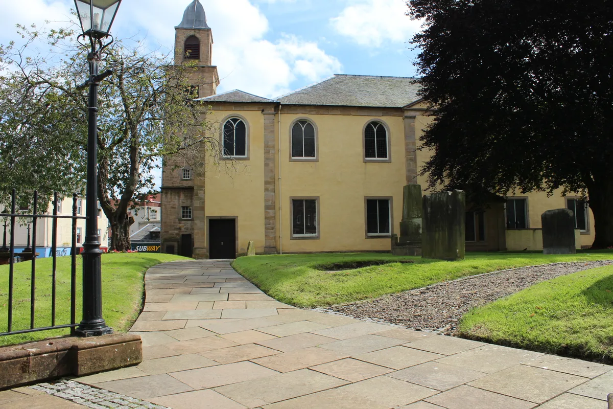
📷 3Historic churches · Central Scotland
Laigh Kirk, Kilmarnock
Laigh Kirk, Kilmarnock — church in East Ayrshire, Scotland, UK.
 📷 3
📷 3Theatres · Central Scotland
The Robert Burns World Federation Ltd
The Robert Burns World Federation Ltd is a theatre in the United Kingdom.
 📷 3
📷 3Memorials & monuments · Central Scotland
Burns and Wilson Monument
Burns and Wilson Monument — a memorial in scotland-central, United Kingdom.
 📷 3
📷 3Galleries · Central Scotland
Gallery 2
Gallery 2 — a gallery in scotland-central, United Kingdom.
 📷 3
📷 3Theatres · Central Scotland
Palace Theatre
Palace Theatre is a theatre in the United Kingdom.
📷 3Galleries · Central Scotland
Driftwood Gallery
Driftwood Gallery — a gallery in scotland-central, United Kingdom.
More bridges in this region
 📷 3
📷 3Historic bridges · Central Scotland
2nd Dalmarnock Railway Bridge
2nd Dalmarnock Railway Bridge is a historic bridge in the United Kingdom.
 📷 4
📷 4Historic bridges · Central Scotland
Abbey Road
Abbey Road is a historic bridge in the United Kingdom.
 📷 4
📷 4Historic bridges · Central Scotland
Albert Bridge
Albert Bridge is a historic bridge in the United Kingdom.
 📷 3
📷 3Historic bridges · Central Scotland
Allan Water Viaduct
Allan Water Viaduct is a historic bridge in the United Kingdom.
Frequently asked questions
- Where is Sandbed Street Bridge?
- Sandbed Street Bridge is in central Scotland, United Kingdom (postcode KA1 1HX).
- Is Sandbed Street Bridge a listed building?
- Sandbed Street Bridge is officially recognised as category C listed building listed.
- Is Sandbed Street Bridge free to visit?
- Yes, Sandbed Street Bridge is free to enter.
- How do I get to Sandbed Street Bridge?
- Drivers can navigate to postcode KA1 1HX. It sits within the Kilmarnock and Loudoun parliamentary constituency.