Lighthouses · Northern Ireland
Sanda Island Lighthouse
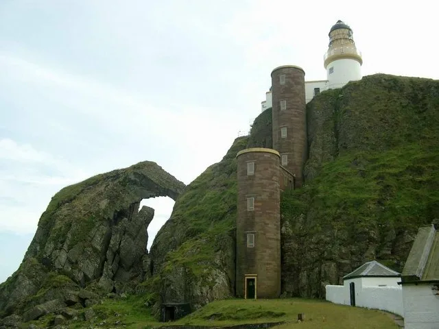
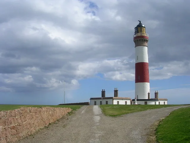
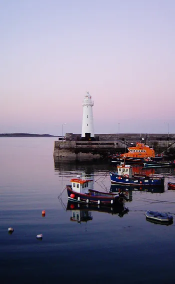
Sanda Island Lighthouse — lighthouse in Argyll and Bute, Scotland, UK.

Wikimedia Commons contributors — see linked file page for photographer and licence licence
Plan your visit
- Typical visit
- 30 min–1 h
- Free entry
- Family-friendly
- Dog-friendly
About
Sanda Island Lighthouse is a lighthouse on the coast of Northern Ireland. Built or established in 1850, it dates from the Victorian period. Officially recognised as category A listed building. Operated by Northern Lighthouse Board. It sits within the Argyll, Bute and South Lochaber parliamentary constituency. Postcode area PA28.
Photo gallery
Heritage listing
Category A Date Added 16/12/2020 Local Authority Argyll And Bute Planning Authority Argyll And Bute Parish Southend NGR NR 72549 03715 Coordinates 172549, 603715 — Sanda Lighthouse was built in 1850 by the Northern Lighthouse Board to plans by the engineer Alan Stevenson. The lighthouse is a complex that comprises a light tower on top of Ship Rock and a two-stage stair tower linking the lighthouse with the pier and other buildings below Ship Rock. The light tower occupies a prominently but isolated coastal clifftop location on the southern side of Sanda Island off the southern end of the Mull of Kintyre. Its purpose was to warn passing seafarers of both Sanda Island itself and several small reefs and rocks adjacent to it. The lighthouse and stair towers are constructed of dressed sandstone, and the light is also harled and whitewashed, with flat roofs. The light tower is a round building around 15m in height. A protruding walkway with metal railings encircles the tower head just below a dome-roofed lantern. The lantern is round with triangular glazing and diagonal metal astragals. Attached to the southeast side of the light tower is a single storey, three bay flat-roofed building with 12 pane timber-framed sash and case windows. The interior of the building has been modernised to support the continuing function of the lighthouse. To the west of these buildings, a later helipad has been installed on Ship Rock and solar panels have been installed on the south. A plastic oil tank has also been added immediately east of the lighthouse and a water tank immediately west. These additions are not of interest in listing terms and are excluded from the listing. The two-stage stair tower is located to the north of the light tower and attached building, to which the uppermost level
From Historic Environment Scotland under OGL v3.
Place summary
Sanda Island Lighthouse is a Victorian lighthouse located in Northern Ireland, postcode PA28. Established in 1850, it is a Category A listed building and is operated by the Northern Lighthouse Board.
AI-generated from the structured facts on this page (operator, designation, listing, era). Not a substitute for visiting.
- Coordinates
- 55.2748, -5.5828
- District
- Argyll and Bute
- Postcode
- PA28 6RS
- Parliamentary constituency
- Argyll, Bute and South Lochaber
- Established
- 1850
Sources
- wikidata: Q26132872 (CC0)
- wikipedia: Sanda lighthouse (CC BY-SA 4.0)
- commons: Sanda Island Lighthouse - geograph.org.uk - 56803.jpg (CC BY-SA 4.0)
Other places nearby
Loading nearby places…
Nearby
 Flagship📷 5
Islands · Northern Ireland
Sanda Island
Sanda Island — a small island in Argyll and Bute, Scotland, UK.
 📷 4
📷 4Natural landmarks · Northern Ireland
HMS Untamed
HMS Untamed in Northern Ireland, United Kingdom.
 📷 5
📷 5Islands · Northern Ireland
Sheep Island
Sheep Island — island in Argyll and Bute, Scotland, UK.
 📷 3
📷 3Islands · Northern Ireland
Glunimore Island
Glunimore Island — island in Argyll and Bute, Scotland, UK.

Archaeological sites · Northern Ireland
Cnoc Eibhleach, dun site
Cnoc Eibhleach, dun site — a archaeological in northern-ireland, United Kingdom.
 📷 3
📷 3Mountains & hills · Northern Ireland
Brunerican Bay
Brunerican Bay — bay at the south of the Mull of Kintyre, Scotland, UK.
More places run by Northern Lighthouse Board
 📷 2
📷 2Lighthouses · Scottish Highlands
An t-Iasgair Light
An t-Iasgair Light — lighthouse in Highland, Scotland, UK.
 📷 3
📷 3Lighthouses · Scottish Highlands
Ardnamurchan Lighthouse
Ardnamurchan Lighthouse — lighthouse in Lochaber, Highland, Scotland, built in 1849.
 📷 3
📷 3Lighthouses · Scottish Highlands
Barra Head Lighthouse
Barra Head Lighthouse — lighthouse in Outer Hebrides, Scotland, UK.
 📷 3
📷 3Lighthouses · Scottish Highlands
Buchan Ness Lighthouse
Buchan Ness Lighthouse — lighthouse in Aberdeenshire, Scotland, UK.
Other lighthouses from this era
 📷 5
📷 5Lighthouses · London
Trinity Buoy Wharf Lighthouse and Chain Locker Block
Trinity Buoy Wharf Lighthouse and Chain Locker Block — lighthouse and historic building in Tower Hamlets, Greater London, England, England.
 📷 5
📷 5Lighthouses · South East England
Anvil Point Lighthouse
Anvil Point Lighthouse — lighthouse in Swanage, Dorset, England, UK.
 📷 5
📷 5Lighthouses · South East England
Egypt Point light
Egypt Point light — lighthouse in Isle of Wight, England.
 📷 5
📷 5Lighthouses · South East England
Folkestone Lighthouse
Folkestone Lighthouse — lighthouse in Folkestone, Shepway, Kent, England, UK.
More lighthouses in this region
Lighthouses · Northern Ireland
Angus Rock Lighthouse
Angus Rock Lighthouse — lighthouse in Down District Council, Northern Ireland.
 📷 5
📷 5Lighthouses · Northern Ireland
Blackhead Lighthouse
Blackhead Lighthouse — lighthouse in Whitehead, County Antrim, Northern Ireland.
 📷 3
📷 3Lighthouses · Northern Ireland
Chaine Memorial
Chaine Memorial — lighthouse in Larne, County Antrim, Northern Ireland.
 📷 3
📷 3Lighthouses · Northern Ireland
Donaghadee lighthouse
Donaghadee lighthouse — lighthouse in Northern Ireland.
Frequently asked questions
- Where is Sanda Island Lighthouse?
- Sanda Island Lighthouse is in Northern Ireland, United Kingdom (postcode PA28 6RS).
- When was Sanda Island Lighthouse built?
- Built or established in 1850.
- Who runs Sanda Island Lighthouse?
- Sanda Island Lighthouse is operated by Northern Lighthouse Board.
- Is Sanda Island Lighthouse a listed building?
- Sanda Island Lighthouse is officially recognised as category A listed building listed.
- Is Sanda Island Lighthouse free to visit?
- Yes, Sanda Island Lighthouse is free to enter.
- How do I get to Sanda Island Lighthouse?
- Drivers can navigate to postcode PA28 6RS. It sits within the Argyll, Bute and South Lochaber parliamentary constituency.