Towns & cities · Central Scotland
Salsburgh
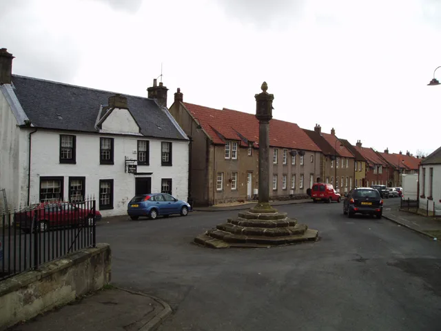
Salsburgh — village in North Lanarkshire, Scotland, UK.

Wikimedia Commons contributors — see linked file page for photographer and licence licence
Plan your visit
- Typical visit
- 3 h–6 h
- Nearest railway station
- Hartwood · 4.2 km
- Free entry
- Family-friendly
- Dog-friendly
About
Salsburgh is a town, city, village or settlement in the United Kingdom. Recent population estimates put it at around 1,350 people. Wikidata describes it as: "village in North Lanarkshire, Scotland, UK". Coordinates: 55.8433°, -3.8742°.
Photo gallery
From the Wikipedia article
Salsburgh is a semi-rural former coal mining village in greenbelt farmland within the district of North Lanarkshire, Scotland. The closest major towns to the village are Shotts, three miles (five kilometres) southeast, and Airdrie three miles (five kilometres) northwest. Salsburgh is perhaps best known for the floodlit Kirk O' Shotts Church, which sits on a hillock and is fairly visible as visitors enter the village from the east on the B7066 Whitburn to Newhouse road. As well as the busy M8 Motorway which runs adjacent to the B7066 and gives the Church the affectionate title 'The M8 Church'.
Excerpt from Wikipedia under CC BY-SA 4.0. See the source article linked in Sources below.
Background
Description
Salsburgh is the locale of the twin BlackHill Transmitters due to its high position towering above the M8 motorway opposite the church. They can be seen as far as Bathgate, West Lothian to the east and Glasgow to the west. The transmitters are quite a prominent feature after dark for miles around, due to the coloured red lights which prevent aircraft from striking the towers. The Kirk o'Shotts transmitting station is also nearby, which formerly carried a TV service and today carries DAB radio.
Sourced from Wikipedia under CC BY-SA 4.0.
- Coordinates
- 55.8433, -3.8742
- District
- North Lanarkshire
- Postcode
- ML7 4LH
- Parliamentary constituency
- Airdrie and Shotts
- Population
- 1,350
- Nearest railway station
- Hartwood — 4.2 km
Sources
- wikidata: Q1009931 (CC0)
- wikipedia: Salsburgh (CC BY-SA 4.0)
- commons: Grossart Street - geograph.org.uk - 1255016.jpg (CC BY-SA 4.0)
Other places nearby
Loading nearby places…
Nearby
 📷 3
📷 3Chapels · Central Scotland
Shottskirk
Shottskirk — chapel east of Salsburgh, North Lanarkshire, Scotland, UK (1450-1821), and well.
 📷 5
📷 5Historic churches · Central Scotland
Kirk of Shotts, Hirst Road, Salsburgh
Kirk of Shotts, Hirst Road, Salsburgh — category B listed building-listed church in scotland-central, United Kingdom.
 📷 4
📷 4Reservoirs & lochs · Central Scotland
Roughrigg
Roughrigg is a reservoir in North Lanarkshire. The reservoir itself is some 137 acres in extent. The reservoir is located about 3 miles (4.8 km) east of Airdrie.
 📷 3
📷 3Natural landmarks · Central Scotland
Learning Circle
Learning Circle — a other in scotland-central, United Kingdom.
 📷 3
📷 3Racecourses · Central Scotland
Forrestburn Hillclimb
Forrestburn Hillclimb — motorcar racetrack near Kirk o' Shotts, North Lanarkshire, Scotland, UK.
 📷 3
📷 3Memorials & monuments · Central Scotland
Shotts Nature Park 10th Anniversary Stone
Shotts Nature Park 10th Anniversary Stone — a memorial in scotland-central, United Kingdom.
More towns in this region
 Flagship📷 3
Towns & cities · Central Scotland
Airth
Airth — village in Falkirk, Scotland, UK.
 Flagship📷 5
Towns & cities · Central Scotland
Avonbridge
Avonbridge — village in Falkirk, Scotland, UK.
 Flagship📷 3
Towns & cities · Central Scotland
Banknock
Banknock — village in Falkirk, Scotland, UK.
 Flagship📷 3
Towns & cities · Central Scotland
Dundee
Dundee — city in Scotland, UK.
Frequently asked questions
- Where is Salsburgh?
- Salsburgh is in central Scotland, United Kingdom (postcode ML7 4LH).
- Is Salsburgh free to visit?
- Yes, Salsburgh is free to enter.
- How do I get to Salsburgh?
- The nearest railway station is Hartwood, about 4.2 km away. Drivers can navigate to postcode ML7 4LH.