Forests & woodlands · West Midlands
Rowley Hills
Rowley Hills is a forest or woodland in the United Kingdom.

Wikimedia Commons licence
Plan your visit
- Typical visit
- 1 h–3 h
- Nearest railway station
- Sandwell and Dudley · 2.1 km
- Free entry
- Family-friendly
- Dog-friendly
About
Rowley Hills is a named forest, woodland or nature reserve in the United Kingdom. Coordinates: 52.4996°, -2.0392°. This entry is part of The Great Britain Guide, a free, ad-free, open-data tourist directory.
Photo gallery
From the Wikipedia article
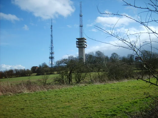
The Rowley Hills are a range of hills in the West Midlands county in England. The range comprises Turner's Hill, Bury Hill, Portway Hill and Darby's Hill. The ridge forms part of the east/west watershed between the River Severn and the River Trent, with rainfall on the western side going to the Bristol Channel via the Severn, and rainfall on the eastern side ending up in the North Sea via the Trent. The hills are situated east of the town of Dudley in Rowley Regis, on the border between the metropolitan boroughs of Dudley and Sandwell. The largest hill, Turner's Hill, is the highest point in the West Midlands county, with an altitude of 269 metres (883 ft) above sea level. Views from the summit include the Clee Hills, Clent Hills, Cannock Chase, and much of Birmingham and the Black Country. The height has also led to the construction of two radio transmission towers on the summit. Portway Hill is the site of a nature reserve of the Wildlife Trust for Birmingham and the Black Country. Rowley Rag, a form of dolerite notably used to make kerbstones, was formerly quarried from the Rowley Hills. Over the centuries that the hills have been inhabited there have been four churches located there, all named St. Giles, in the village of Rowley.
Excerpt from Wikipedia under CC BY-SA 4.0. See the source article linked in Sources below.
- Coordinates
- 52.4996, -2.0392
- District
- Sandwell
- Parish
- Sandwell, unparished area
- Postcode
- B69 1NX
- Parliamentary constituency
- West Bromwich
- Nearest railway station
- Sandwell and Dudley — 2.1 km
Sources
- osm: w255606287 (ODbL)
- wikipedia: Rowley Hills (CC BY-SA 4.0)
Other places nearby
Loading nearby places…
Nearby
 📷 3
📷 3Viewpoints · West Midlands
Brummichum View
Brummichum View is a viewpoint in the United Kingdom.
 📷 3
📷 3Wildlife reserves · West Midlands
Portway Hill
Portway Hill — nature reserve in West Midlands, UK.
 📷 3
📷 3Public art & sculpture · West Midlands
Tales of Rowley
Tales of Rowley — a public art in england-west-midlands, United Kingdom.
📷 3Viewpoints · West Midlands
Massey Bank Viewpoint
Massey Bank Viewpoint is a viewpoint in the United Kingdom.
 📷 3
📷 3Mountains & hills · West Midlands
Turners Hill
Turners Hill — Named summit at 271 m.
 📷 3
📷 3Viewpoints · West Midlands
Darby's Hill Viewpoint
Darby's Hill Viewpoint is a viewpoint in the United Kingdom.
More forests in this region
 📷 3
📷 3Forests & woodlands · West Midlands
Abington Meadows Nature Reserve
Abington Meadows Nature Reserve is a forest or woodland in the United Kingdom.
_(geograph_2935627).jpg?width=1200) 📷 3
📷 3Forests & woodlands · West Midlands
Adderbury Lakes
Adderbury Lakes is a forest or woodland in the United Kingdom.
 📷 3
📷 3Forests & woodlands · West Midlands
Alcott Wood
Alcott Wood is a forest or woodland in the United Kingdom.
 📷 3
📷 3Forests & woodlands · West Midlands
Alvecote Meadows Nature Reserve
Alvecote Meadows Nature Reserve is a forest or woodland in the United Kingdom.
Frequently asked questions
- Where is Rowley Hills?
- Rowley Hills is in the West Midlands, United Kingdom (postcode B69 1NX), in the parish of Sandwell, unparished area.
- Is Rowley Hills free to visit?
- Yes, Rowley Hills is free to enter.
- How do I get to Rowley Hills?
- The nearest railway station is Sandwell and Dudley, about 2.1 km away. Drivers can navigate to postcode B69 1NX.