Museums · South West England
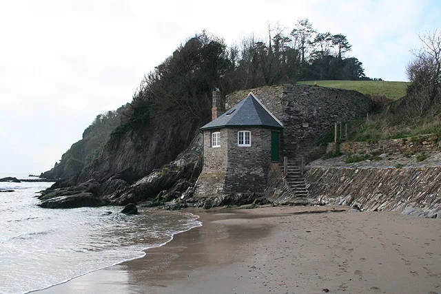
River Erme
River Erme — a museum in england-south-west, United Kingdom.

Martin Bodman — CC BY-SA 2.0 via Wikimedia Commons licence
Plan your visit
- Typical visit
- 1.5 h–3 h
- Best time of year
- Year-round
- Family-friendly
- Limited wheelchair access
About
River Erme is a museum in england-south-west, United Kingdom, listed in the Wikipedia register of British heritage and tourism sites. See the linked Wikipedia article for full details.
Photo gallery
Place summary
The River Erme is located in South-West England. It is notable for its natural beauty and ecological significance, serving as a habitat for various wildlife. The river is part of the region's landscape and contributes to the area's biodiversity.
AI-generated from the structured facts on this page (operator, designation, listing, era). Not a substitute for visiting.
Background
History
In 1991 and 1992 some 42 tin ingots were found in the mouth of the estuary on the north side of the West Mary Reef. These date from between 500 BC and 600 AD. Tin mining was in existence on Dartmoor from an early date. Dartmoor tin-mining would have been a major part of the South Devon economy throughout its history. There is an Iron Age hill fort at Holbury near Holbeton overlooking the estuary from the west and evidence of a very early 11th Century fort and settlement just a little way inland at Oldaport. In the 1950s and again in the 1990s a variety of fragments of "Dark Ages" and Roman pots were discovered on Mothecombe beach. There are four ruined lime kilns in the estuary; all are in…
Description
As it passes to the east of the village of Holbeton the Erme becomes a ria with extensive areas of salt marsh and mud that are uncovered at low tide. The geology of the area is mostly slate from the Devonian period. The river enters the English Channel near the villages of Kingston to the east and Mothecombe and Holbeton to the west and at the mouth of the estuary lie the beaches of Wonwell and Mothecombe. The estuary is surrounded by the 5,000 acre Flete Estate.
Visiting
The estuary is now designated as an Area of Outstanding Natural Beauty, and an Erme Estuary Management Plan has been produced. The South West Coast Path crosses between the slipways on the Wonwell (eastern) and Mothecombe (western) sides of the estuary, but crossing is only possible at low tide - and even then walkers are very likely to get their knees wet. The alternative route by road is some 9 miles around the estuary. The 1947 Ordnance Survey map show this as a vehicular ford between the slipways. There is another ford marked on the 1947 map between Saltercrease and Efford, but this is now said to be too deep to cross.
Sourced from Wikipedia under CC BY-SA 4.0.
- Coordinates
- 50.3080, -3.9509
- County
- Devon
- District
- South Hams
- Parish
- Holbeton
- Postcode
- PL8 1LB
- Parliamentary constituency
- South West Devon
Sources
- wikipedia: River Erme (CC BY-SA 4.0)
Other places nearby
Loading nearby places…
Nearby
 📷 5
📷 5Beaches · South West England
Mothecombe Beach
Mothecombe Beach is a beach in the United Kingdom.
 📷 5
📷 5Beaches · South West England
Meadowsfoot Beach
Meadowsfoot Beach is a beach in the United Kingdom.
 📷 3
📷 3Hill forts · South West England
Salcombe Cannon Wreck
Salcombe Cannon Wreck — marine archaeological site in the Erme Estuary, Devon, England, UK.
 📷 5
📷 5Beaches · South West England
Mothecombe Beach
Mothecombe Beach — beach in Devon, United Kingdom.
 📷 5
📷 5Beaches · South West England
Red Cove
Red Cove is a beach in the United Kingdom.
 📷 3
📷 3Beaches · South West England
Wonwell Beach
Wonwell Beach is a beach in the United Kingdom.
More museums in this region
 📷 5
📷 5Museums · South West England
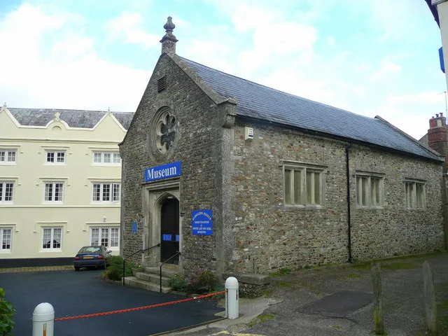
Allhallows Museum
Allhallows Museum — museum in Honiton, Devon, England, United Kingdom.
 📷 5
📷 5Museums · South West England
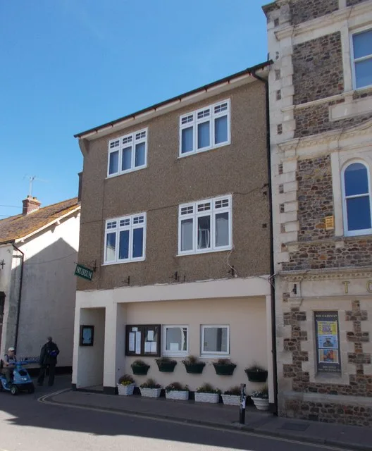
Axe Valley Heritage Museum
Axe Valley Heritage Museum — museum in Seaton, England, UK.
 📷 5
📷 5Museums · South West England
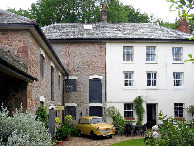
Bakelite Museum
Bakelite Museum is a museum in the United Kingdom.
 📷 5
📷 5Museums · South West England
Barometer World
Barometer World — former museum in Devon, England.
Frequently asked questions
- Where is River Erme?
- River Erme is in South West England, in the United Kingdom — coordinates 50.3080°, -3.9509°.
- Is River Erme wheelchair accessible?
- Partially — OpenStreetMap notes limited wheelchair access at River Erme. Check ahead for specific facilities.