Public art & sculpture · Central Scotland
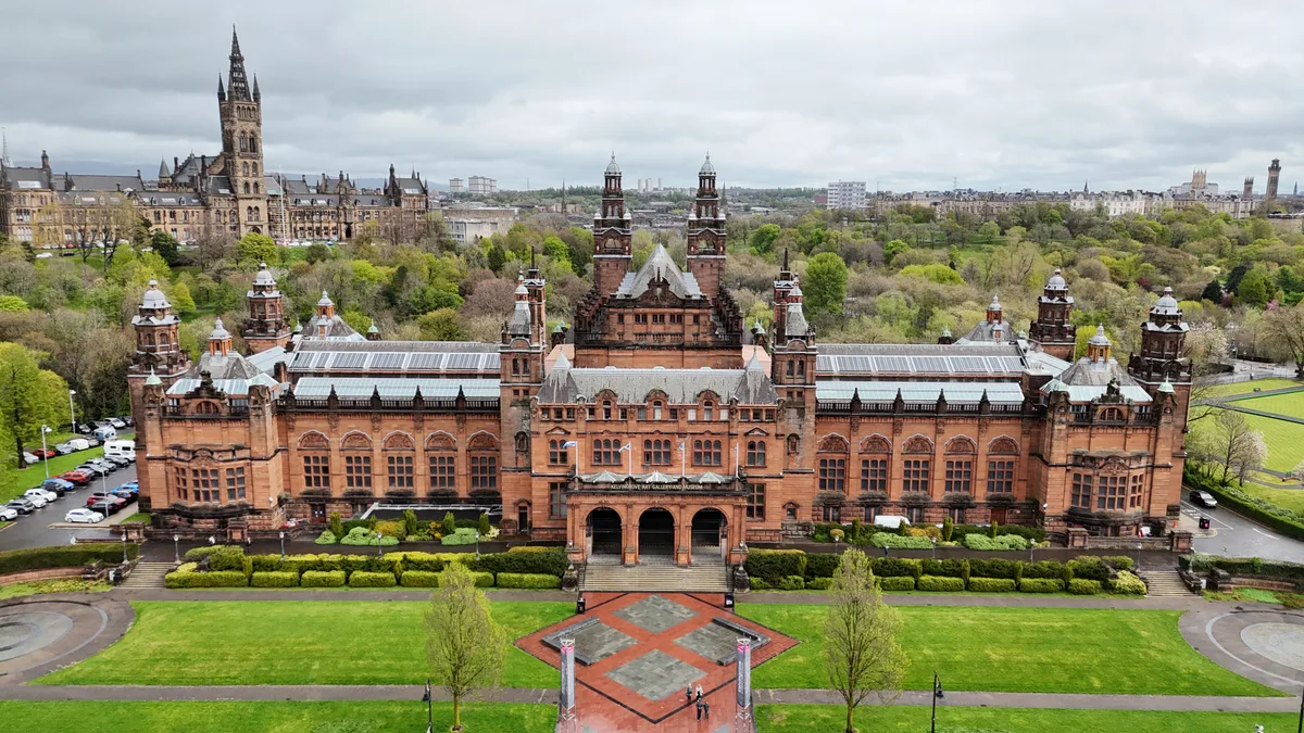
Relief Map of the West End of Glasgow
Relief Map of the West End of Glasgow — a public art in scotland-central, United Kingdom.

Richard Sutcliffe — CC BY-SA 2.0 via Wikimedia Commons licence
Plan your visit
- Typical visit
- 1 h–2 h
- Free entry
- Dog-friendly
About
Relief Map of the West End of Glasgow is a public art located in scotland-central, United Kingdom. Sourced from OpenStreetMap (ODbL licence); see local listings for visitor information, opening hours and admission details.
Photo gallery
Place summary
The Relief Map of the West End of Glasgow is a public art installation located in central Scotland. This large-scale topographical model provides a three-dimensional representation of the area, showcasing its geographical features and urban layout.
AI-generated from the structured facts on this page (operator, designation, listing, era). Not a substitute for visiting.
- Coordinates
- 55.8692, -4.2921
- District
- Glasgow City
- Postcode
- G3 8AG
- Parliamentary constituency
- Glasgow North
- Phone
- +44 141 276 9599
- Official site
- www.glasgowlife.org.uk
Sources
- osm: node/7158652905 (ODbL)
Other places nearby
Loading nearby places…
Nearby
 📷 3
📷 3Memorials & monuments · Central Scotland
The Cameronians (Scottish Rifles) Memorial
The Cameronians (Scottish Rifles) Memorial — a memorial in scotland-central, United Kingdom.
📷 4Public art & sculpture · Central Scotland
Cameronians War Memorial
Cameronians War Memorial in Scotland Central, United Kingdom.
 📷 3
📷 3Memorials & monuments · Central Scotland
602 (City of Glasgow) Squadron Memorial
602 (City of Glasgow) Squadron Memorial — a memorial in scotland-central, United Kingdom.
📷 3Memorials & monuments · Central Scotland
Normandy Veterans Memorial
Normandy Veterans Memorial — a memorial in scotland-central, United Kingdom.
 📷 4
📷 4Galleries · Central Scotland
Kelvingrove Art Gallery and Museum
Kelvingrove Art Gallery and Museum — Museum and art gallery near Glasgow in Scotland.
 📷 5
📷 5Historic bridges · Central Scotland
Bridge, Kelvingrove Park, Glasgow
Bridge, Kelvingrove Park, Glasgow — category B listed building-listed bridge in scotland-central, United Kingdom.
More places in this region
 📷 4
📷 4Public art & sculpture · Central Scotland
Bust of Carlo Antonio del Pozzo
Bust of Carlo Antonio del Pozzo in Scotland Central, United Kingdom.
 📷 3
📷 3Public art & sculpture · Central Scotland
Equestrian statue of Prince Albert
Equestrian statue of Prince Albert in Scotland Central, United Kingdom.
 📷 4
📷 4Public art & sculpture · Central Scotland
Equestrian statue of Robert the Bruce
Equestrian statue of Robert the Bruce in Scotland Central, United Kingdom.
 📷 3
📷 3Public art & sculpture · Central Scotland
King's Own Scottish Borderers Memorial
King's Own Scottish Borderers Memorial in Scotland Central, United Kingdom.
Frequently asked questions
- Where is Relief Map of the West End of Glasgow?
- Relief Map of the West End of Glasgow is in central Scotland, United Kingdom (postcode G3 8AG).
- Is Relief Map of the West End of Glasgow free to visit?
- Yes, Relief Map of the West End of Glasgow is free to enter.
- How do I get to Relief Map of the West End of Glasgow?
- Drivers can navigate to postcode G3 8AG. It sits within the Glasgow North parliamentary constituency.