Harbours & ports · South East England
Poole Harbour
Poole Harbour — harbour in Dorset, England.

Wikimedia Commons contributors — see linked file page for photographer and licence licence
Plan your visit
- Typical visit
- 45 min–1.5 h
- Nearest railway station
- Poole · 2.6 km
- Family-friendly
- Dog-friendly
About
Poole Harbour is a harbour in the United Kingdom. Wikidata describes it as: "harbour in Dorset, England". Coordinates: 50.6958°, -1.9886°.
Photo gallery
Protected designations
- Site of Special Scientific Interest: Poole Harbour SSSI
- National Nature Reserve: PURBECK HEATHS
- Area of Outstanding Natural Beauty: Dorset
- Ramsar wetland: Poole Harbour
Designations sourced from Natural England open data under OGL v3.
From the Wikipedia article
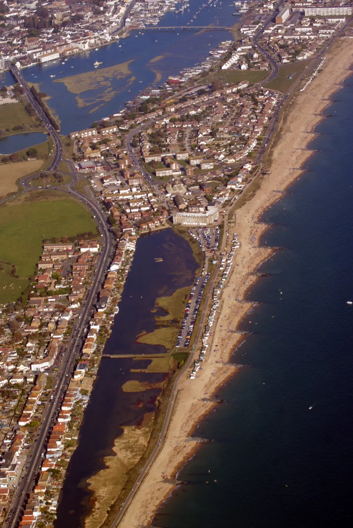
Poole Harbour is a large natural harbour in Dorset, southern England, with the town of Poole on its shores. The harbour is a drowned valley (ria) formed at the end of the last ice age and is the estuary of several rivers, the largest being the Frome. The harbour has a long history of human settlement stretching to pre-Roman times. The harbour is extremely shallow (average depth 48 cm [19 in]), with one main dredged channel through the harbour, from the mouth to Holes Bay. Poole Harbour has an area of approximately 36 km2 (14 sq mi). It is one of several which lay claim to the title of "second largest natural harbour in the world" (after Port Jackson, Sydney).
Excerpt from Wikipedia under CC BY-SA 4.0. See the source article linked in Sources below.
Background
History
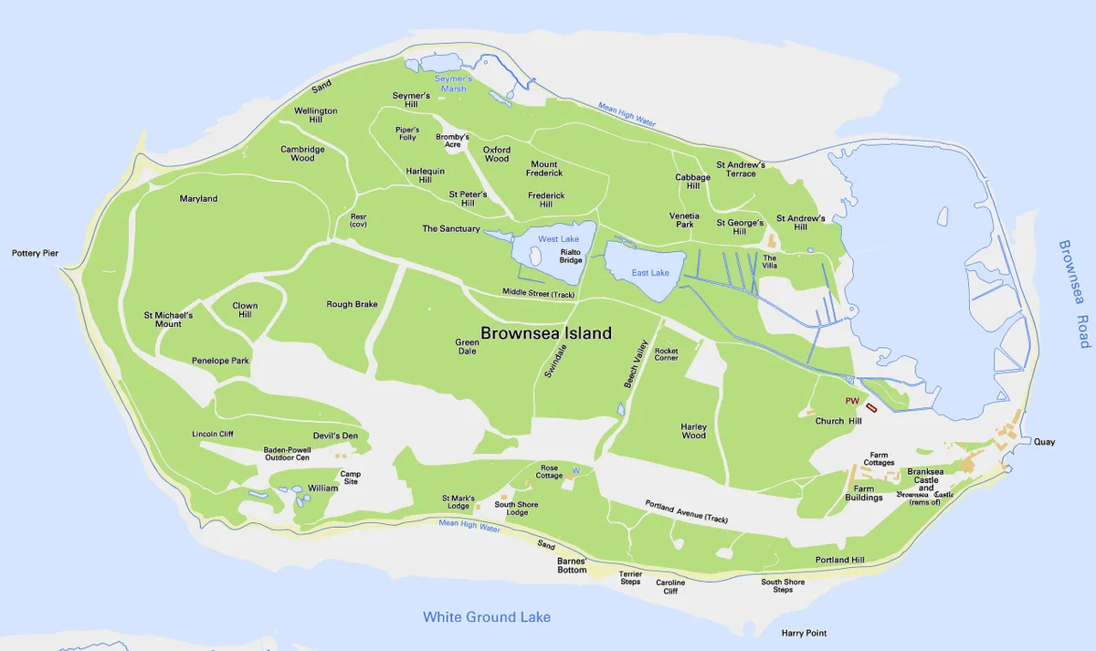
was excavated from Poole Harbour and is over 2,000 years old. It is on display in Poole Museum.]] In 1964 during harbour dredging, the waterlogged remains of a 2,000-year-old Iron Age logboat were found off Brownsea Island. Dated at about 295 BC, the 10 m Poole Logboat is one of the largest vessels of its type from British waters. Its low freeboard would have limited its use to within Poole Harbour. Poole was used by the Romans as an invasion port for the conquest of southern England, who established the settlement at Hamworthy, now the western half of Poole. A Roman Road ran north from Hamworthy through a fort at Lake Farm, Ashington, to Badbury Rings, a Roman transport hub. At the time of…
Sourced from Wikipedia under CC BY-SA 4.0.
- Coordinates
- 50.6958, -1.9886
- Parish
- Bournemouth, Christchurch and Poole, unparished area
- Postcode
- BH15 4AJ
- Parliamentary constituency
- Poole
- Nearest railway station
- Poole — 2.6 km
- Official site
- rsis.ramsar.org
Sources
- wikidata: Q1645369 (CC0)
- wikipedia: Poole Harbour (CC BY-SA 4.0)
- commons: GreenandFurzeyIsland.jpg (CC BY-SA 4.0)
Other places nearby
Loading nearby places…
Nearby
 📷 5
📷 5Museums · South East England
River Frome, Dorset
River Frome, Dorset — a museum in england-south-east, United Kingdom.
Vineyards · South East England
Maryland
Maryland — a UK vineyard in england south east, producing English or Welsh wine from cool-climate grape varieties.
 📷 5
📷 5Piers · South East England
Pottery Pier
Pottery Pier is a pier in the United Kingdom.
Campsites · South East England
Baden Powell Outdoor Centre
Baden Powell Outdoor Centre — a campsite in england south east.
 📷 5
📷 5Memorials & monuments · South East England
Baden-Powell First Camp Memorial
Baden-Powell First Camp Memorial — a memorial in england-south-east, United Kingdom.
 Flagship📷 10
Islands · South East England
Brownsea Island
Brownsea Island — island in Poole Harbour, Dorset, England, UK.
More places in this region
 Flagship📷 10
Harbours & ports · South East England
Shoreham-by-Sea
Shoreham-by-Sea — seaside town and port in West Sussex, England.
 📷 5
📷 5Harbours & ports · South East England
Chichester Harbour
Chichester Harbour — Harbour & Site of Special Scientific Interest in Chichester, West Sussex.
 📷 5
📷 5Harbours & ports · South East England
Colt Hill Wharf
Colt Hill Wharf is a harbour in the United Kingdom.
_2025-03-02.jpg?width=1200) 📷 5
📷 5Harbours & ports · South East England
Cormorant
Cormorant — Public artwork (sculpture) by Christian Funnell.
Frequently asked questions
- Where is Poole Harbour?
- Poole Harbour is in South-East England, United Kingdom (postcode BH15 4AJ), in the parish of Bournemouth, Christchurch and Poole, unparished area.
- Is Poole Harbour a protected site?
- Yes — Poole Harbour is part of the Poole Harbour SSSI Site of Special Scientific Interest and the PURBECK HEATHS National Nature Reserve.
- How do I get to Poole Harbour?
- The nearest railway station is Poole, about 2.6 km away. Drivers can navigate to postcode BH15 4AJ.