Canal locks · London
Penton Hook Lock
Penton Hook Lock — lock on the River Thames in Surrey, England.

Wikimedia Commons contributors — see linked file page for photographer and licence licence
Plan your visit
- Typical visit
- 20 min–45 min
- Nearest railway station
- Staines · 2.0 km
- Free entry
- Dog-friendly
About
Penton Hook Lock is a canal lock in the United Kingdom. Wikidata describes it as: "lock on the River Thames in Surrey, England". Coordinates: 51.4147°, -0.5003°.
Photo gallery
From the Wikipedia article
Penton Hook Lock is the sixth lowest lock of forty four on the non-tidal reaches of the River Thames in England. It faces an island which was until its construction a pronounced meander (a hook) and is on the site of its seasonal cutoff. It is against the left bank marking the church parish medieval border of Laleham and Staines upon Thames in Surrey for many centuries. Until 1965 their county was Middlesex. At 266 ft (81 m) it is the third longest lock on the river. A bend 1000 yards (900 metres) upstream of the lock, Silvery Sands, hosts Staines Regatta in the sport of rowing annually. On the opposite bank in Thorpe is Penton Hook Marina which occupies lakes once land used for gravel extraction.
Excerpt from Wikipedia under CC BY-SA 4.0. See the source article linked in Sources below.
Background
History
Problems were long caused in erosion and to navigation by floodwaters topping the neck of the meander (a seasonal meander cutoff). The Corporation promoted the funding of the lock with formalised weirs in 1809, and Parliament passed its enabling act 1814. The lock was completed in 1815, two years after Chertsey Lock, as the Thames lock furthest upstream controlled by the City of London Corporation, whose arms appear on the Lock Cottage built in 1814. It soon became the sixth lock proceeding upstream, as it is today. The main weir was built in 1846 when positioned below the offtake of the Abbey River, a medieval-established leat and so sited for the benefit of watermill power; the grain…
Visiting
The lock is accessible on foot or bicycle along the towpath from Blacksmiths Lane and its spur Riverside or Penton Hook Road. The lock is against the left bank marking the Church parish medieval border of Laleham and Staines upon Thames in Surrey since at least the Norman Conquest. By boat the lock can be accessed from Thorpe on the right bank.
Sourced from Wikipedia under CC BY-SA 4.0.
- Coordinates
- 51.4147, -0.5003
- County
- Surrey
- District
- Runnymede
- Parish
- Runnymede, unparished area
- Postcode
- KT16 8RS
- Parliamentary constituency
- Runnymede and Weybridge
- Nearest railway station
- Staines — 2 km
- Official site
- www.environment-agency.gov.uk
Sources
- wikidata: Q7165265 (CC0)
- wikipedia: Penton Hook Lock (CC BY-SA 4.0)
- commons: Penton Hook Lock on a beautiful Autumn day - geograph.org.uk - 1025368.jpg (CC BY-SA 4.0)
Other places nearby
Loading nearby places…
Nearby
 📷 5
📷 5Historic churches · London
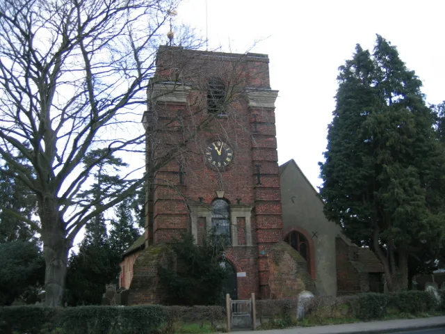
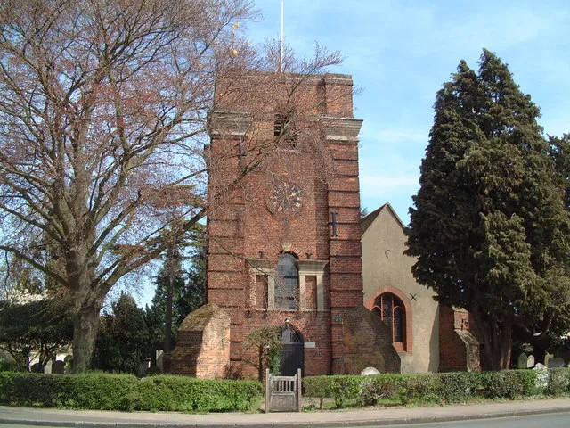
Church of All Saints
Church of All Saints — church in Laleham, Surrey, England, UK.
 Flagship📷 10
Towns & cities · London
Laleham
Laleham — village in the Spelthorne borough, United Kingdom.
 📷 5
📷 5Memorials & monuments · London
Model Railway Sign
Model Railway Sign — a memorial in england-london, United Kingdom.
📷 5Miniature railways · London
Staines Park Miniature Railway
Staines Park Miniature Railway — a miniature railway in england-london, United Kingdom.
 📷 5
📷 5Public art & sculpture · London
Fairy and Tree
Fairy and Tree — a public art in england-london, United Kingdom.
 📷 5
📷 5Natural landmarks · London
Depth Charge
Depth Charge — a other in england-london, United Kingdom.
More places in this region
 📷 5
📷 5Canal locks · London
Acton's Lock
Acton's Lock — lock in London Borough of Hackney, London, England, UK.
 📷 5
📷 5Canal locks · London
Aqueduct Lock
Aqueduct Lock — lock on the River Lee Navigation near Turnford, Hertfordshire, England, UK.
 📷 5
📷 5Canal locks · London
Baits Bite Lock, River Cam
Baits Bite Lock, River Cam is a canal lock in the United Kingdom.
 📷 5
📷 5Canal locks · London
Barrelled Lock Chamber, Sea Walls, Swing Bridge, Locks And Canal Basin
Barrelled Lock Chamber, Sea Walls, Swing Bridge, Locks And Canal Basin — bridge in Gravesham, Kent, England, UK.
Frequently asked questions
- Where is Penton Hook Lock?
- Penton Hook Lock is in London, in the United Kingdom — coordinates 51.4147°, -0.5003°. The nearest railway station is Staines, around 2 km away.
- Is Penton Hook Lock free to visit?
- Yes — admission to Penton Hook Lock is free.