Historic bridges · South West England
Pensford Viaduct
Pensford Viaduct is a historic bridge in the United Kingdom.

Wikimedia Commons contributors — see linked file page for photographer and licence licence
Plan your visit
- Typical visit
- 15 min–30 min
- Nearest railway station
- Keynsham · 6.5 km
- Free entry
- Dog-friendly
About
Pensford Viaduct is a named historic bridge in the United Kingdom. Coordinates: 51.3708°, -2.5514°. This entry is part of The Great Britain Guide, a free, ad-free, open-data tourist directory.
Photo gallery
Protected designations
- Site of Special Scientific Interest: Severn Estuary SSSI
Designations sourced from Natural England open data under OGL v3.
From the Wikipedia article
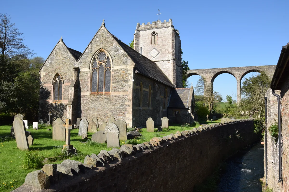
Pensford Viaduct is a disused railway bridge in the village of Pensford, within the historic English county of Somerset, now unitary authority Bath and North East Somerset. It is a Grade II listed building. The viaduct was 330 yards long; the track has since been lifted but the arches still remain today.
Excerpt from Wikipedia under CC BY-SA 4.0. See the source article linked in Sources below.
Background
History
The viaduct was built in 1874 to carry the Bristol and North Somerset Railway over the valley of the River Chew. The contractor was J. Perry, of Tredegar Works, Bow. During construction the bridge failed and had to be rebuilt. The last scheduled passenger train to cross the viaduct was the 9:25 a.m. from Frome to Bristol on 31 October 1959; after that there were only goods trains (mainly bringing coal from Radstock), which ceased in 1964, and very occasional excursion trains. It officially closed after the Chew Stoke flood of 1968 which damaged the viaduct and other buildings in Pensford and the wider Chew Valley. The viaduct was offered for sale for £1, in 1984; It became the property of…
Architecture
Construction is of stone piers and spandrels with red brick soffits. The viaduct is 995 ft long, reaches a maximum height of 95 ft to rail level and consists of sixteen arches. The arches are of different widths and heights and supported by tall, tapering piers in the centre and thicker shorter ones towards the sides. Arches 5 and 13 are lower than the others dividing the bridge into sections with four higher arches at each end. Subsequent repairs were made with concrete rather than stone, though it was dressed to look similar to the surrounding stone.
Sourced from Wikipedia under CC BY-SA 4.0.
- Coordinates
- 51.3708, -2.5514
- District
- Bath and North East Somerset
- Parish
- Publow
- Postcode
- BS39 4AG
- Parliamentary constituency
- North East Somerset and Hanham
- Nearest railway station
- Keynsham — 6.5 km
- Opening
- | inaugurated =
Sources
- osm: w1360398974 (ODbL)
- wikipedia: Pensford Viaduct (CC BY-SA 4.0)
- commons: Pensford Viaduct - geograph.org.uk - 717285.jpg (CC BY-SA 4.0)
Other places nearby
Loading nearby places…
Nearby
 📷 3
📷 3Historic churches · South West England
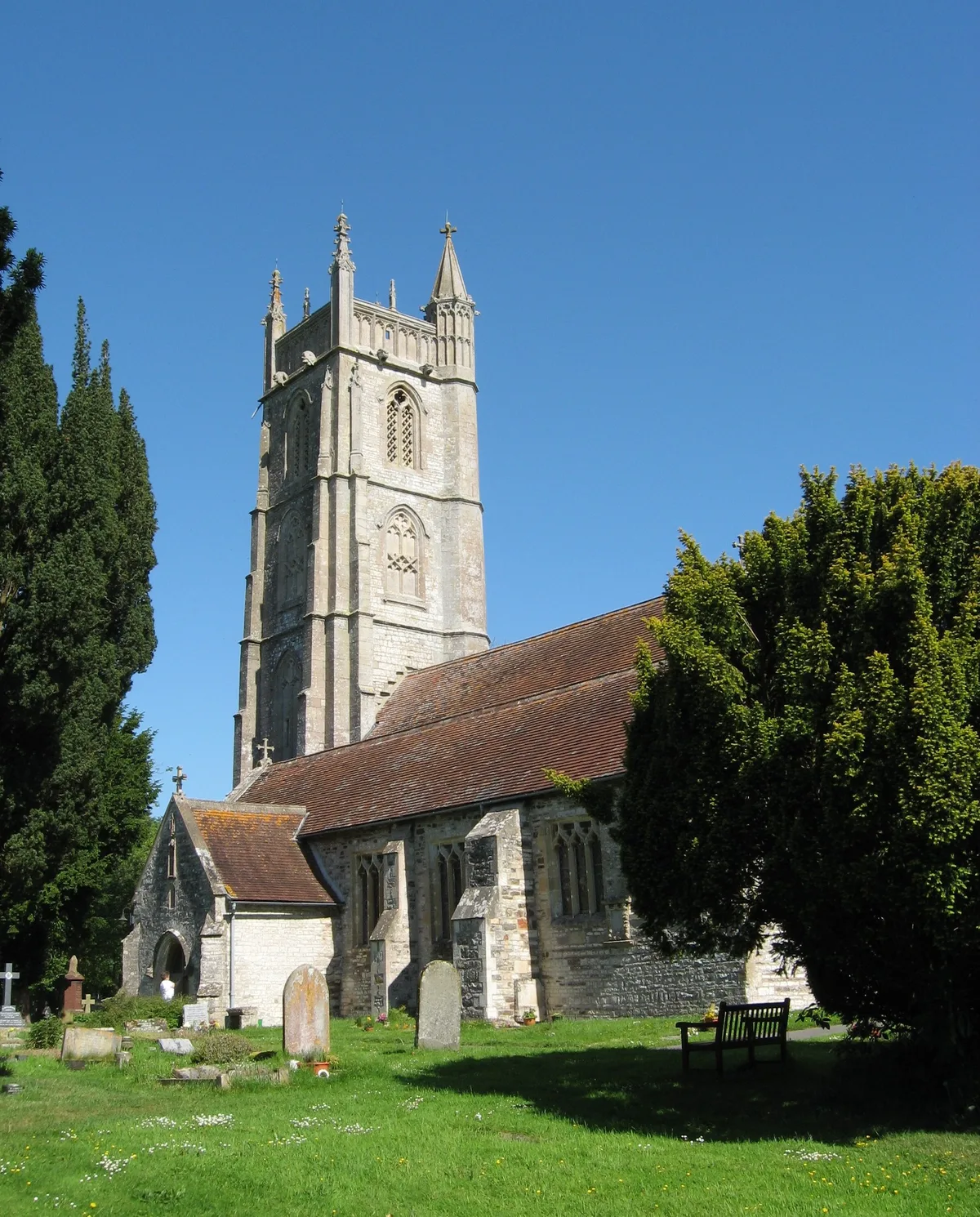
St Thomas à Becket Church, Pensford
St Thomas à Becket Church, Pensford — church in Pensford, Somerset, England, UK.
 📷 4
📷 4Memorials & monuments · South West England
Acker Bilk
Acker Bilk — a memorial in england-south-west, United Kingdom.
 📷 3
📷 3Historic bridges · South West England
Bridge Over The River Chew
Bridge Over The River Chew — Grade II listed building-listed bridge in england-south-west, United Kingdom.
 📷 3
📷 3Memorials & monuments · South West England
Pensford War Memorial
Pensford War Memorial — Grade II listed building-listed memorial in england-south-west, United Kingdom.
 📷 3
📷 3Historic bridges · South West England
Publow Bridge
Publow Bridge — Grade II listed building-listed bridge in england-south-west, United Kingdom.
 📷 5
📷 5Historic churches · South West England
Church of All Saints, Publow
Church of All Saints, Publow — church in Publow, Bath and North East Somerset, England, UK.
More bridges in this region
 📷 5
📷 5Historic bridges · South West England
Albert Road Viaduct
Albert Road Viaduct is a historic bridge in the United Kingdom.
 📷 5
📷 5Historic bridges · South West England
Angarrack Viaduct
Angarrack Viaduct is a historic bridge in the United Kingdom.
 📷 5
📷 5Historic bridges · South West England
Avon Bridge
Avon Bridge is a historic bridge in the United Kingdom.
 📷 5
📷 5Historic bridges · South West England
Bailey Bridge
Bailey Bridge is a historic bridge in the United Kingdom.
Frequently asked questions
- Where is Pensford Viaduct?
- Pensford Viaduct is in South-West England, United Kingdom (postcode BS39 4AG), in the parish of Publow.
- Who owns Pensford Viaduct?
- Pensford Viaduct is owned by Highways Agency Historical Railways Estate.
- Is Pensford Viaduct a protected site?
- Yes — Pensford Viaduct is part of the Severn Estuary SSSI Site of Special Scientific Interest.
- Is Pensford Viaduct free to visit?
- Yes, Pensford Viaduct is free to enter.
- How do I get to Pensford Viaduct?
- The nearest railway station is Keynsham, about 6.5 km away. Drivers can navigate to postcode BS39 4AG.