Historic churches · South West England
Pendeen
Pendeen (from Cornish: Penn Din meaning "headland fort", previously known as Cornish: Boskaswal Wartha, meaning "Caswal's high dwelling") is a village and ecclesiastical parish on the Penwith peninsul

Paul Barnett — CC BY-SA 2.0 via Wikimedia Commons licence
Plan your visit
- Typical visit
- 30 min–1 h
- Free entry
About
Pendeen (from Cornish: Penn Din meaning "headland fort", previously known as Cornish: Boskaswal Wartha, meaning "Caswal's high dwelling") is a village and ecclesiastical parish on the Penwith peninsula in Cornwall, England. It is 3 miles (5 kilometres) north-northeast of St Just and 7 mi (11 km) west of Penzance. It lies along the B3306 road which connects St Ives to Land's End and the A30 road. The village has a community centre, a shop, a post office, a primary school, and a few small businesses. Community activities include an art club, a gardening club, silver marching band and a football club. Nearby settlements include Carnyorth and Trewellard and the historic Geevor Tin Mine is immediately north of the village. The village gets its name from the headland on which Pendeen Lighthouse stands, a mile from the village. Like many other Cornish villages near the coast, Pendeen had a reputation for smuggling activities. Pendeen is overlooked by a hill, Carn Eanes, referred to locally as 'The Carn', the site of a quarry which provided the granite to build Pendeen church. Pendeen lies within the Cornwall Area of Outstanding Natural Beauty (AONB) and the St Just in Penwith division of Cornwall Council. Pendeen is close (1 km) to the South West Coast Path and in addition has a number of local footpaths for exploring the surroundings.
Photo gallery
From the Wikipedia article
Pendeen (from Cornish: Penn Din meaning "headland fort", previously known as Cornish: Boskaswal Wartha, meaning "Caswal's high dwelling") is a village and ecclesiastical parish on the Penwith peninsula in Cornwall, England. It is 3 miles (5 kilometres) north-northeast of St Just and 7 mi (11 km) west of Penzance. It lies along the B3306 road which connects St Ives to Land's End and the A30 road. The village has a community centre, a shop, a post office, a primary school, and a few small businesses. Community activities include an art club, a gardening club, silver marching band and a football club. Nearby settlements include Carnyorth and Trewellard and the historic Geevor Tin Mine is immediately north of the village. The village gets its name from the headland on which Pendeen Lighthouse stands, a mile from the village. Like many other Cornish villages near the coast, Pendeen had a reputation for smuggling activities. Pendeen is overlooked by a hill, Carn Eanes, referred to locally as 'The Carn', the site of a quarry which provided the granite to build Pendeen church. Pendeen lies within the Cornwall Area of Outstanding Natural Beauty (AONB) and the St Just in Penwith division of Cornwall Council. Pendeen is close (1 km) to the South West Coast Path and in addition has a number of local footpaths for exploring the surroundings.
Excerpt from Wikipedia under CC BY-SA 4.0. See the source article linked in Sources below.
Background
History
The area now known as the Parochial Parish of Pendeen, was originally referred to as North St Just and was formed in 1846. It included a number of settlements in the eastern part of the Parochial Parish of St Just.<sup>[1]</sup> Today the Parochial Parish of Pendeen comprises the settlements of Bojewyan, Portheras Cross, Boscaswell Downs, Lower Boscaswell, Trewellard, Carnyorth and part of Botallack. This area remains part of the civil parish of St Just. Before the splitting of the Parish in 1846 "Pendeen" would have referred to the eponymous headland or Pendeen Manor, birthplace of William Borlase, rather than any of the settlements listed above.
Architecture
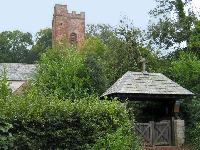
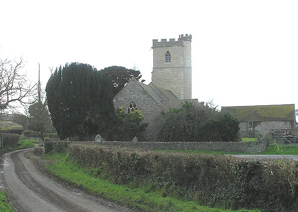
The Church of St John the Baptist is built of local granite and is a Grade II listed building. It was designed by the first vicar Robert Aitken and was based on Iona Abbey. It was built by the villagers from 1850 to 1852 and refurbished in 1878. The church tower was elevated in 1890, ″... to bring it into better proportion to the body of the edifice; ...″, alongwith the installation of a clock and four dials. Oliver Caldwell was the architect and the work cost £270. There is a Cornish cross in the vicarage garden. At Pendeen Manor Farm is a 16th-century farmhouse (front added in 1670) and a fogou or vau 56 ft long, with a side passage of 24 ft.
Sourced from Wikipedia under CC BY-SA 4.0.
- Coordinates
- 50.1521, -5.6618
- District
- Cornwall
- Parish
- St. Just
- Postcode
- TR19 7DS
- Parliamentary constituency
- St Ives
Sources
- wikipedia: Pendeen (CC BY-SA 4.0)
Other places nearby
Loading nearby places…
Nearby
Campsites · South West England
North Inn Camping
North Inn Camping — a campsite in england south west.
 📷 3
📷 3Memorials & monuments · South West England
Pendeen War Memorial
Pendeen War Memorial — Grade II listed building-listed memorial in england-south-west, United Kingdom.
 📷 3
📷 3Historic bridges · South West England
Bridge Over Stream Immediately West Of Number 14
Bridge Over Stream Immediately West Of Number 14 — Grade II listed building-listed bridge in england-south-west, United Kingdom.
📷 3Historic bridges · South West England
Bridge Over Stream West Of Numbers 5 To 12
Bridge Over Stream West Of Numbers 5 To 12 — Grade II listed building-listed bridge in england-south-west, United Kingdom.
 📷 3
📷 3Museums · South West England
Hard Rock Museum
Hard Rock Museum — a museum in england-south-west, United Kingdom.
 📷 3
📷 3Museums · South West England
Geevor Tin Mine
Geevor Tin Mine — a museum in england-south-west, United Kingdom.
More places in this region
 📷 5
📷 5Historic churches · South West England
Abbey Church of St Mary and St Petroc
Abbey Church of St Mary and St Petroc — church in Bodmin, Cornwall, England, UK; former monastic church.
 📷 5
📷 5Historic churches · South West England
All Saints Church
All Saints Church — church in Dodington, West Somerset, England, UK.
 📷 5
📷 5Historic churches · South West England
All Saints Church, Otterhampton
All Saints Church, Otterhampton — church in Otterhampton, Somerset, England, UK.
 📷 5
📷 5Historic churches · South West England
All Saints Church, South Milton
All Saints Church, South Milton — church in South Milton, Devon, England, UK.
Frequently asked questions
- Where is Pendeen?
- Pendeen is in South-West England, United Kingdom (postcode TR19 7DS), in the parish of St. Just.
- Is Pendeen free to visit?
- Yes, Pendeen is free to enter.
- How do I get to Pendeen?
- Drivers can navigate to postcode TR19 7DS. It sits within the St Ives parliamentary constituency.