Mountains & hills · North West England
Pen-y-ghent
Also known as: Penyghent
Pen-y-ghent — Named summit at 694 m.

Wikimedia Commons contributors — see linked file page for photographer and licence licence
Plan your visit
- Typical visit
- 3 h–8 h
- Best time of year
- Late spring – early autumn (May–Oct)
- Nearest railway station
- Horton-in-Ribblesdale · 3.6 km
- Free entry
- Dog-friendly
About
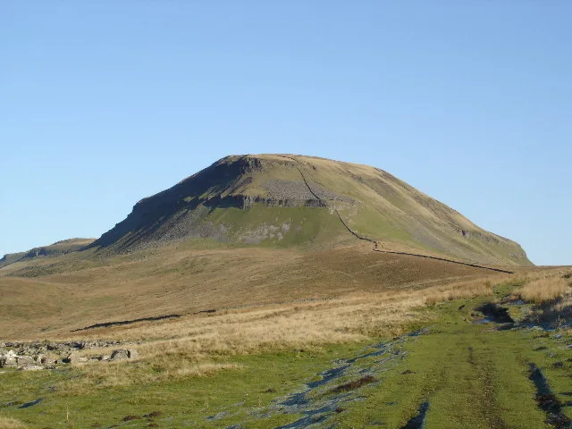
Pen-y-ghent is a named summit in the United Kingdom. Also known as: Penyghent. Wikidata describes it as: "Named summit at 694 m.". Coordinates: 54.1560°, -2.2488°.
Photo gallery
Protected designations
- Site of Special Scientific Interest: Pen-Y-Ghent SSSI
- Site of Special Scientific Interest: Brants Gill Catchment SSSI
Designations sourced from Natural England open data under OGL v3.
From the Wikipedia article
Pen-y-ghent or Penyghent is a fell in the Yorkshire Dales, England. It is the lowest of Yorkshire's Three Peaks at 2,277 feet (694 m); the other two being Ingleborough and Whernside. It lies 1.9 miles (3 km) east of Horton in Ribblesdale. It has a number of interesting geological features, such as Hunt Pot, and further down, Hull Pot. The waters that flow in have created an extensive cave system which rises at Brants Gill head. In 2004 the body of Lamduan Armitage, dubbed by the media the "Lady of the Hills", was found near to the entrance of Sell Gill Hole.
Excerpt from Wikipedia under CC BY-SA 4.0. See the source article linked in Sources below.
- Coordinates
- 54.1560, -2.2488
- District
- North Yorkshire
- Parish
- Malham Moor
- Postcode
- BD24 9PW
- Parliamentary constituency
- Skipton and Ripon
- Nearest railway station
- Horton-in-Ribblesdale — 3.6 km
Sources
- osm: n312154686 (ODbL)
- wikipedia: Pen-y-ghent (CC BY-SA 4.0)
- commons: Fawcett Moor and Pen-y-Ghent - geograph.org.uk - 80390.jpg (CC BY-SA 4.0)
Other places nearby
Loading nearby places…
Nearby
 📷 5
📷 5Natural landmarks · North West England
Pen-y-ghent
Pen-y-ghent — mountain in the United Kingdom.
 📷 5
📷 5Caves · North West England
Penyghent Pot
Penyghent Pot is a cave in the United Kingdom.
Mountain bike trails · North West England
Great North Trail (Yorkshire Dales)
Great North Trail (Yorkshire Dales) — a mtb trail in england north west.
 📷 3
📷 3Caves · North West England
Hunt Pot
Hunt Pot is a cave in the United Kingdom.
📷 5Caves · North West England
Brackenbottom Pot
Brackenbottom Pot — a cave broad in england-north-west, United Kingdom.

Caves · North West England
Giggel Rav Pot
Giggel Rav Pot — a cave broad in england-north-west, United Kingdom.
More mountains in this region
 📷 3
📷 3Mountains & hills · North West England
Allen Crags
Allen Crags — Named summit at 785 m.
 📷 3
📷 3Mountains & hills · North West England
Alum Pot
Alum Pot — Open shaft pothole in North Yorkshire.
 📷 3
📷 3Mountains & hills · North West England
Arnside Knott
Arnside Knott — Named summit at 159 m.
 📷 3
📷 3Mountains & hills · North West England
Aye Gill Pike
Aye Gill Pike — Named summit at 556.3 m.
Frequently asked questions
- Where is Pen-y-ghent?
- Pen-y-ghent is in North-West England, United Kingdom (postcode BD24 9PW), in the parish of Malham Moor.
- Is Pen-y-ghent a protected site?
- Yes — Pen-y-ghent is part of the Pen-Y-Ghent SSSI Site of Special Scientific Interest and the Brants Gill Catchment SSSI Site of Special Scientific Interest.
- Is Pen-y-ghent free to visit?
- Yes, Pen-y-ghent is free to enter.
- How do I get to Pen-y-ghent?
- The nearest railway station is Horton-in-Ribblesdale, about 3.6 km away. Drivers can navigate to postcode BD24 9PW.