Towns & cities · South East England
Pembury
Pembury — village in Kent, England, UK.

Wikimedia Commons contributors — see linked file page for photographer and licence licence
Plan your visit
- Typical visit
- 3 h–6 h
- Nearest railway station
- High Brooms · 3.1 km
- Free entry
- Family-friendly
- Dog-friendly
About
Pembury is a town, city, village or settlement in the United Kingdom. Recent population estimates put it at around 5,785 people. Wikidata describes it as: "village in Kent, England, UK". Coordinates: 51.1456°, 0.3224°.
Photo gallery
Protected designations
- Area of Outstanding Natural Beauty: High Weald
- Area of Outstanding Natural Beauty: Kent Downs
Designations sourced from Natural England open data under OGL v3.
From the Wikipedia article
Pembury is a large village in Kent, in the south east of England, with a population of 6,128 at the 2011 census. It lies just to the north-east of Royal Tunbridge Wells. The village centre, including the village green and High Street area is a conservation area.
Excerpt from Wikipedia under CC BY-SA 4.0. See the source article linked in Sources below.
Background
History
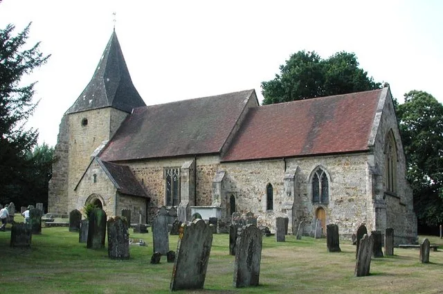
A settlement in Pembury almost certainly predates the Norman Conquest, as the village church of St Peter is of Norman origin. It is thought to have been built in the early 12th or late 11th century, though the earliest it can be dated with certainty is to 1337, when John Culpeper of Bayhall carried out building work to the church. The first recorded mention of Pembury is as "Peppingeberia" in the 12th-century Textus Roffensis, though Edward Hasted states that it was also known in ancient deeds as "Pepenbery". With the widespread introduction of the motor vehicle in the early 20th century, Pembury Hospital hosted a centre of groundbreaking research and treatment for hodophobia (fear of road…
Description
Usually referred to as the "Old Church", the parish church is located in woods outside the village, near Kent College and the waterworks north of the A228. It was first built in the late 11th or early 12th century, although most of the present church was added in 1337.
Sourced from Wikipedia under CC BY-SA 4.0.
- Coordinates
- 51.1456, 0.3224
- County
- Kent
- District
- Tunbridge Wells
- Parish
- Pembury
- Postcode
- TN2 4EX
- Parliamentary constituency
- Tunbridge Wells
- Population
- 5,785
- Nearest railway station
- High Brooms — 3.1 km
- Official site
- www.neighbourhood.statistics.gov.uk
Sources
- wikidata: Q1918003 (CC0)
- wikipedia: Pembury (CC BY-SA 4.0)
- commons: View east along Pembury High St - geograph.org.uk - 1302169.jpg (CC BY-SA 4.0)
Other places nearby
Loading nearby places…
Nearby
 📷 5
📷 5Memorials & monuments · South East England
War Memorial
War Memorial is a memorial in the United Kingdom.
📷 5Memorials & monuments · South East England
Men of Pembury War Memorial
Men of Pembury War Memorial — Grade II listed building-listed memorial in england-south-east, United Kingdom.
Hotels · South East England
The Camden Arms Hotel
The Camden Arms Hotel — a hotel in england south east.
 📷 5
📷 5Historic churches · South East England
Old Church of St Peter
Old Church of St Peter — church in Pembury, Kent, England, UK.
 📷 5
📷 5Theatres · South East England
Odeon Tunbridge Wells
Odeon Tunbridge Wells in England South East, United Kingdom.
 📷 5
📷 5Natural landmarks · South East England
The Skinners’ Kent Academy
The Skinners’ Kent Academy — a school heritage in england-south-east, United Kingdom.
More towns in this region
 Flagship📷 10
Towns & cities · South East England
Aldermaston
Aldermaston — village and civil parish in West Berkshire in England, UK.
 Flagship📷 10
Towns & cities · South East England
Aldingbourne
Aldingbourne — village and civil parish in Arun, West Sussex, UK.
 Flagship📷 10
Towns & cities · South East England
Aldington
Aldington — village and civil parish in the Ashford District of Kent, England.
 Flagship📷 10
Towns & cities · South East England
Aldworth
Aldworth — village and civil parish in the English county of Berkshire.
Frequently asked questions
- Where is Pembury?
- Pembury is in Kent, South-East England, United Kingdom (postcode TN2 4EX), in the parish of Pembury.
- Is Pembury a protected site?
- Yes — Pembury is part of the High Weald National Landscape (AONB) and the Kent Downs National Landscape (AONB).
- Is Pembury free to visit?
- Yes, Pembury is free to enter.
- How do I get to Pembury?
- The nearest railway station is High Brooms, about 3.1 km away. Drivers can navigate to postcode TN2 4EX.