Wildlife reserves · Northern Ireland
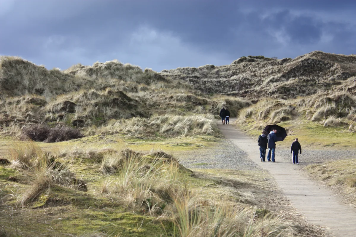
Oxford Island
Oxford Island — nature reserve in the United Kingdom.

Wikimedia Commons contributors — see linked file page for photographer and licence licence
Plan your visit
- Typical visit
- 2 h–4 h
- Best time of year
- Autumn & winter (migration & wildfowl)
- Nearest railway station
- Lurgan · 3.5 km
- Free entry
- Dog-friendly
About
Oxford Island is a wildlife reserve in the United Kingdom. It covers approximately 113 km². Owned by Craigavon Borough Council. Managed by Craigavon Borough Council. Wikidata describes it as: "nature reserve in the United Kingdom". Coordinates: 54.4900°, -6.3753°.
Photo gallery
From the Wikipedia article
Oxford Island is a National Nature Reserve and public recreation site on the southern shores of Lough Neagh at Lurgan, County Armagh. The site covers 282 acres (113 hectares) and is owned and maintained by Armagh City, Banbridge and Craigavon Borough Council. Much of the area is designated as a National Nature Reserve due to its wide variety of natural habitats. The purpose of all work on the island is to maintain biodiversity and to provide a recreation area for everyone.
Excerpt from Wikipedia under CC BY-SA 4.0. See the source article linked in Sources below.
Background
History
In 1846 the water level in Lough Neagh was lowered artificially for the first time, and Oxford Island became a peninsula. Under the Craigavon New City Plans, Oxford Island was acquired as a site for public recreation. At that time most of the land was cultivated or grazed so that any natural vegetation cover was eradicated. Since the acquisition by Craigavon Borough Council in the late 1960s, many thousands of mixed woodland trees have been planted, the Lough shore allowed to develop naturally and the meadows have largely reverted to species rich grassland.
Sourced from Wikipedia under CC BY-SA 4.0.
- Coordinates
- 54.4900, -6.3753
- Postcode
- BT66 6NJ
- Parliamentary constituency
- Upper Bann
- Nearest railway station
- Lurgan — 3.5 km
Sources
- wikidata: Q24673838 (CC0)
- wikipedia: Oxford Island (CC BY-SA 4.0)
- commons: Wildlife Shelter 1 - geograph.org.uk - 890859.jpg (CC BY-SA 4.0)
Other places nearby
Loading nearby places…
Nearby
Caravan parks · Northern Ireland
Kinnego Marina Camping & Caravanning
Kinnego Marina Camping & Caravanning — a caravan park in northern ireland.
 📷 3
📷 3Science centres · Northern Ireland
Lough Neagh Discovery Centre
Lough Neagh Discovery Centre — a other in northern-ireland, United Kingdom.
 📷 3
📷 3Natural landmarks · Northern Ireland
M1 motorway
M1 motorway in Northern Ireland, United Kingdom.
 📷 2
📷 2Towns & cities · Northern Ireland
Derrymacash
Derrymacash — village in County Armagh, Northern Ireland, UK.
 📷 3
📷 3Towns & cities · Northern Ireland
Aghacommon
Aghacommon — village in County Armagh, Northern Ireland, UK.
 📷 2
📷 2Natural landmarks · Northern Ireland
Lurgan College
Lurgan College in Northern Ireland, United Kingdom.
More places in this region
 Flagship📷 4
Wildlife reserves · Northern Ireland
Murlough Nature Reserve
Murlough Nature Reserve — Irish nature reserve.
 📷 3
📷 3Wildlife reserves · Northern Ireland
Banagher Glen
Banagher Glen — Protected area in Northern Ireland.
 📷 3
📷 3Wildlife reserves · Northern Ireland
Belshaw's Quarry Nature Reserve
Belshaw's Quarry Nature Reserve — nature reserve in County Antrim, Northern Ireland.
 📷 3
📷 3Wildlife reserves · Northern Ireland
Bog Meadows
Bog Meadows — nature reserve in Belfast, Northern Ireland, UK.
Frequently asked questions
- Where is Oxford Island?
- Oxford Island is in Northern Ireland, United Kingdom (postcode BT66 6NJ).
- Who runs Oxford Island?
- Oxford Island is operated by Craigavon Borough Council.
- Is Oxford Island free to visit?
- Yes, Oxford Island is free to enter.
- How do I get to Oxford Island?
- The nearest railway station is Lurgan, about 3.5 km away. Drivers can navigate to postcode BT66 6NJ.
- Are dogs allowed at Oxford Island?
- Most wildlife reserves allow dogs on lead only, with restrictions during ground-nesting bird season (March-July). Check signage at the reserve.