Towns & cities · East of England
Ousden
Ousden — village and civil parish of Suffolk, England.

Wikimedia Commons contributors — see linked file page for photographer and licence licence
Plan your visit
- Typical visit
- 3 h–6 h
- Nearest railway station
- Kennett · 8.9 km
- Free entry
- Family-friendly
- Dog-friendly
About
Ousden is a town, city, village or settlement in the United Kingdom. Recent population estimates put it at around 233 people. Wikidata describes it as: "village and civil parish of Suffolk, England". Coordinates: 52.2060°, 0.5510°.
Photo gallery
From the Wikipedia article
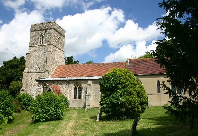
Ousden is a village and civil parish in the West Suffolk district of Suffolk in eastern England. It is located around 6 miles (10 km) west of Bury St Edmunds and 72 miles (116 km) north of London, and as of 2011, its population is 266. The village has an Anglican church of St Peter's and a chapel in the cemetery dedicated to St Barnabas. In the 1870s, Ousden was described as: "A village and a parish in the district of Newmarket and county of Suffolk. The village stands 1½ mile E of the boundary with Cambridgeshire, 4¾ S by W of Higham r. station, and 6½ E S E of Newmarket."
Excerpt from Wikipedia under CC BY-SA 4.0. See the source article linked in Sources below.
Background
History
Ousden dates back to the Anglo-Saxon era. The name is derived from Old English and literally translates to 'owl valley'. In the Domesday Book Ousden is referred to as 'Uuesdana' and shows that in 1066 it consisted of 27 households, considered to be a 'quite large' village, and part of the Hundred of Risbridge. There was a population of fifteen villagers, nine smallholders and two slaves. There were six acres of land and four cobs, 15 cattle, 22 pigs and 158 sheep. The Lord of Ousden in 1066 was Leofric, but by 1086 the Lord and tenant-in-chief was Eustace, Count of Boulogne. The parish church, St Peter's, also dates from around this time. It is a place of interest because it is a Norman…
Sourced from Wikipedia under CC BY-SA 4.0.
- Coordinates
- 52.2060, 0.5510
- County
- Suffolk
- District
- West Suffolk
- Parish
- Ousden
- Postcode
- CB8 8UD
- Parliamentary constituency
- West Suffolk
- Population
- 233
- Nearest railway station
- Kennett — 8.9 km
- Official site
- neighbourhood.statistics.gov.uk
Sources
- wikidata: Q269255 (CC0)
- wikipedia: Ousden (CC BY-SA 4.0)
- commons: UK Ousden.jpg (CC BY-SA 4.0)
Other places nearby
Loading nearby places…
Nearby
 📷 3
📷 3Public art & sculpture · East of England
Ousden Village Sign
Ousden Village Sign — a public art in england-east, United Kingdom.
.jpg?width=1200) 📷 3
📷 3Historic houses · East of England
Badmondisfield Hall
Badmondisfield Hall — house in Wickhambrook, West Suffolk, England, UK.
 📷 3
📷 3Public art & sculpture · East of England
Hargrave Village Sign
Hargrave Village Sign — a public art in england-east, United Kingdom.
 📷 3
📷 3Castles · East of England
Lidgate Castle
Lidgate Castle — castle in Suffolk, England, UK.
 📷 3
📷 3Castles · East of England
Castle gate house wall
Castle gate house wall — a castle in england-east, United Kingdom.
📷 3Memorials & monuments · East of England
Lidgate War Memorial
Lidgate War Memorial — Grade II listed building-listed memorial in england-east, United Kingdom.
More towns in this region
 Flagship📷 3
Towns & cities · East of England
Alburgh
Alburgh — village and civil parish in Norfolk, UK.
 Flagship📷 3
Towns & cities · East of England
Aldeby
Aldeby — village and civil parish in Norfolk, UK.
 Flagship📷 5
Towns & cities · East of England
Ashill
Ashill — village and civil parish in the English county of Norfolk.
 Flagship📷 3
Towns & cities · East of England
Aslacton
Aslacton — village and civil parish in Norfolk, UK.
Frequently asked questions
- Where is Ousden?
- Ousden is in Suffolk, East of England, United Kingdom (postcode CB8 8UD), in the parish of Ousden.
- Is Ousden free to visit?
- Yes, Ousden is free to enter.
- How do I get to Ousden?
- Drivers can navigate to postcode CB8 8UD. It sits within the West Suffolk parliamentary constituency.