Towns & cities · Yorkshire & the Humber
Nunburnholme
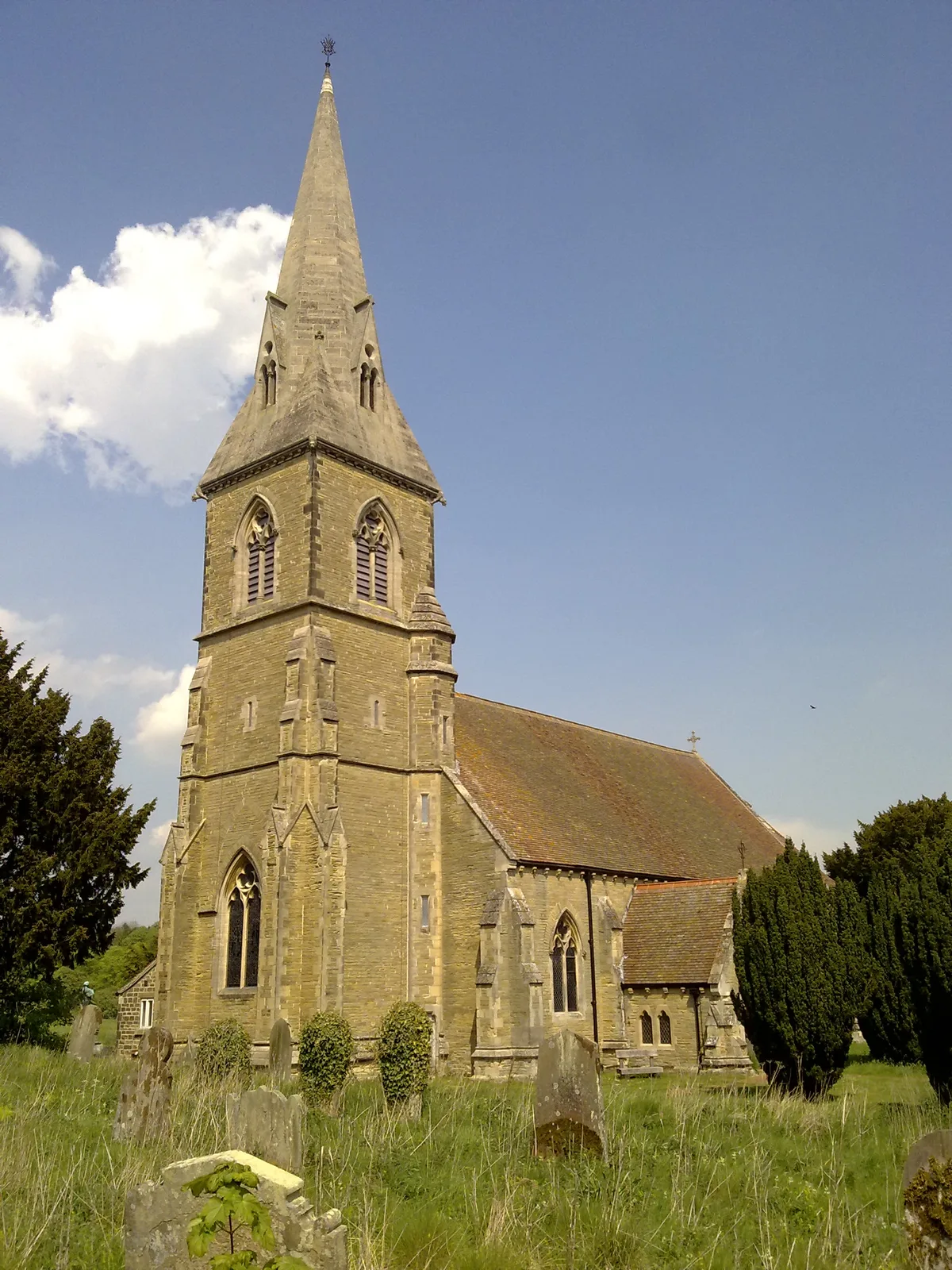
Nunburnholme — a village located in East Riding of Yorkshire, United Kingdom.

Wikimedia Commons contributors — see linked file page for photographer and licence licence
Plan your visit
- Typical visit
- 3 h–6 h
- Free entry
- Family-friendly
- Dog-friendly
About
Nunburnholme is a town, city, village or settlement in the United Kingdom. Recent population estimates put it at around 234 people. Address: YO42. Wikidata describes it as: "a village located in East Riding of Yorkshire, United Kingdom". Coordinates: 53.9219°, -0.7077°.
Photo gallery
From the Wikipedia article
Nunburnholme is a village and civil parish in the East Riding of Yorkshire, England. It is approximately 3 miles (5 km) east of the market town of Pocklington. The civil parish is formed by the village of Nunburnholme and the hamlet of Kilnwick Percy. According to the 2011 UK census, Nunburnholme parish had a population of 234, a decrease on the 2001 UK census figure of 253. Nunburnholme derives its name from the Old English Burnholme (“burn” = spring, stream; “holm” = island in a river, and was variously spelt Brunnum, Brunham and Brunne in medieval times. The prefix “Nun-“ was added some time before the 16th century with reference to Nunburnholme Priory. Nunburnholme was laid waste during the Harrying of the North in 1069–70 and was still deserted in 1086. The entry for the manor of Brunham in the Domesday Book reads: "Terra Tainorum Regis. East Riding. Hessle Hundred. Manerium. In Brunham, Morcar, Turvet and Turchil had 11 carucates of taxable land. There is land for six ploughs. One carucate is soke in Pocklington. Forne holds it of the King, and it is waste." The parish church of St James is a Grade I listed building, noted for its former incumbents the Reverend Francis Orpen Morris, author of works on natural history, and his son, the Rev. Marmaduke Charles Frederick Morris, antiquarian and author. During restoration in 1872–7 two sections of an important late Anglo-Saxon cross-shaft were discovered walled up in the church. The Nunburnholme Cross now stands within the church, its two sections incorrectly mounted back to front. The highly ornamented faces of the cross-shaft comprise Anglo-Saxon Christian figures, an unusual haloed warrior in profile, and later pagan Viking and Norman additions. The Yorkshire Wolds Way National Trail, a long-distance footpath, passes through the village, as does the 60-mile (97 km) Wilberforce Way, which runs from Kingston upon Hull to York. In 1823 Nunburnholme was a civil parish in the Wapentake of Harthill. Baines stated…
Excerpt from Wikipedia under CC BY-SA 4.0. See the source article linked in Sources below.
- Coordinates
- 53.9219, -0.7077
- District
- East Riding of Yorkshire
- Parish
- Nunburnholme
- Postcode
- YO42
- Parliamentary constituency
- Bridlington and The Wolds
- Population
- 234
Sources
- wikidata: Q576488 (CC0)
- wikipedia: Nunburnholme (CC BY-SA 4.0)
- commons: Church of St James, Nunburnholme - geograph.org.uk - 1563778.jpg (CC BY-SA 4.0)
Other places nearby
Loading nearby places…
Nearby
 📷 5
📷 5Historic churches · Yorkshire & the Humber
Madhyamaka Buddhist Centre
Madhyamaka Buddhist Centre — a church in england-yorkshire, United Kingdom.
 📷 5
📷 5Historic churches · Yorkshire & the Humber
St James' Church, Warter
St James' Church, Warter — church building in Warter, East Riding of Yorkshire, England, UK.
 📷 3
📷 3Abbeys & priories · Yorkshire & the Humber
Site of Augustinian Priory
Site of Augustinian Priory — a abbey in england-yorkshire, United Kingdom.
 📷 3
📷 3Archaeological sites · Yorkshire & the Humber
Medieval Village of Easthorpe
Medieval Village of Easthorpe — a archaeological in england-yorkshire, United Kingdom.
Caravan parks · Yorkshire & the Humber
South Lea
South Lea — a caravan park in england yorkshire.
 📷 3
📷 3Museums · Yorkshire & the Humber
The Stewart Museum
The Stewart Museum — museum in York, England, United Kingdom.
More towns in this region
 Flagship📷 4
Towns & cities · Yorkshire & the Humber
Bradford
Bradford — city and largest settlement in the City of Bradford district, Yorkshire, England.
 Flagship📷 5
Towns & cities · Yorkshire & the Humber
Coxwold
Coxwold — village and civil parish in North Yorkshire, England.
 Flagship📷 5
Towns & cities · Yorkshire & the Humber
Great Ayton
Great Ayton — village in North Yorkshire, England, UK.
May2005.jpg?width=1200) Flagship📷 5
Flagship📷 5Towns & cities · Yorkshire & the Humber
Great Langton
Great Langton — village in North Yorkshire, England, UK.
Frequently asked questions
- Where is Nunburnholme?
- Nunburnholme is in Yorkshire, United Kingdom (postcode YO42), in the parish of Nunburnholme.
- Is Nunburnholme free to visit?
- Yes, Nunburnholme is free to enter.
- How do I get to Nunburnholme?
- Drivers can navigate to postcode YO42. It sits within the Bridlington and The Wolds parliamentary constituency.