Towns & cities · Scottish Highlands
Newtonmore
Also known as: Baile Ùr an t-Slèibh
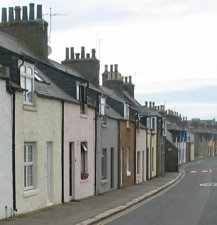
Newtonmore — village in Highland, Scotland, UK.

Wikimedia Commons contributors — see linked file page for photographer and licence licence
Plan your visit
- Typical visit
- 3 h–6 h
- Nearest railway station
- Newtonmore · 1.1 km
- Free entry
- Family-friendly
- Dog-friendly
About
Newtonmore is a town, city, village or settlement in the United Kingdom. Recent population estimates put it at around 1,100 people. Address: PH20. Wikidata describes it as: "village in Highland, Scotland, UK". Coordinates: 57.0692°, -4.1188°.
Photo gallery
From the Wikipedia article
Newtonmore (Scottish Gaelic: Baile Ùr an t-Slèibh [ˈpˠalʲ uːɾˠ ən̪ˠ ˈt̪ʰlʲeːv]) is a village of approximately 1100 inhabitants in Badenoch, within the Highland council area of Scotland. The village is only a few miles from a location that is claimed to be the exact geographical centre of Scotland. Newtonmore is located within the Cairngorms National Park, approximately 3 miles (5 km) south-west of Kingussie and 15 miles (24 km) south-west of Aviemore. It is on the northeastern bank of the River Spey, between the River Calder and the Allt Lairaidh, at an altitude of approximately 250 metres (820 ft).
Excerpt from Wikipedia under CC BY-SA 4.0. See the source article linked in Sources below.
Background
History
Newtonmore does not appear on William Roy's Survey of Scotland (1747–1752), however some of the surrounding crofts do including Bannaker, now Banchor Mains Farm, on the banks of the Calder. In 1756, a bridge was constructed over the River Spey at the confluence of the River Calder near Ralia, largely replacing the ferry 4 mi downstream at Ruthven. The road to Kingussie was realigned along the north bank of the Spey and the village founded by James Macpherson of Belleville to house dispossessed tenantry, the first houses being built in 1820 where the Perth-Inverness Road met the old drove road to Laggan, between the River Calder and the Allt Laraidh. The settlement was sometimes known as…
Visiting
in Newtonmore ]] The village is home to The Wildcat Experience, aimed at families with children, where participants try to track down the 130 painted model wildcats located around the village. It is based on a community arts project – but everyone in the village had the chance to be involved. Newtonmore is the site of the open-air Highland Folk Museum since the 1980s. It is located on Kingussie Road, on the eastern outskirts of the village. The village is also home to the Clan Macpherson House and Museum, situated at the junction of Perth Road, Laggan Road and Main Street. The museum opened in 1952, with the exhibition mainly containing items from the nearby Cluny Castle which had recently…
Sourced from Wikipedia under CC BY-SA 4.0.
- Coordinates
- 57.0692, -4.1188
- District
- Highland
- Postcode
- PH20
- Parliamentary constituency
- Moray West, Nairn and Strathspey
- Population
- 1,100
- Nearest railway station
- Newtonmore — 1.1 km
- Official site
- www.newtonmore.com
Sources
- wikidata: Q1010363 (CC0)
- wikipedia: Newtonmore (CC BY-SA 4.0)
- commons: Newtonmore2.gif (CC BY-SA 4.0)
Other places nearby
Loading nearby places…
Nearby
Hostels · Scottish Highlands
Strathspey Mountain Hostel
Strathspey Mountain Hostel — a hostel in scotland highlands.
 📷 3
📷 3Viewpoints · Scottish Highlands
The Craggan View Point
The Craggan View Point is a viewpoint in the United Kingdom.
 📷 3
📷 3Memorials & monuments · Scottish Highlands
Newtonmore War Memorial
Newtonmore War Memorial — a memorial in scotland-highlands, United Kingdom.
Hostels · Scottish Highlands
Pine Cottage
Pine Cottage — a hostel in scotland highlands.
 📷 3
📷 3Memorials & monuments · Scottish Highlands
Preface
Preface — a memorial in scotland-highlands, United Kingdom.
📷 3Gardens · Scottish Highlands
Newtonmore Centenary Gardens
Newtonmore Centenary Gardens — a other in scotland-highlands, United Kingdom.
More towns in this region
 Flagship📷 3
Towns & cities · Scottish Highlands
Cruden Bay
Cruden Bay — village in Aberdeenshire, Scotland, UK.
 Flagship📷 3
Towns & cities · Scottish Highlands
Inverness
Inverness — city in the Highlands of Scotland, United Kingdom.
 Flagship📷 3
Towns & cities · Scottish Highlands
Kyle of Lochalsh
Kyle of Lochalsh — village in Highland, Scotland, UK.
 📷 4
📷 4Towns & cities · Scottish Highlands
Aberchirder
Aberchirder — village in Aberdeenshire, Scotland, UK.
Frequently asked questions
- Where is Newtonmore?
- Newtonmore is in the Scottish Highlands, United Kingdom (postcode PH20).
- Is Newtonmore free to visit?
- Yes, Newtonmore is free to enter.
- How do I get to Newtonmore?
- The nearest railway station is Newtonmore, about 1.1 km away. Drivers can navigate to postcode PH20.