Towns & cities · London
Nettlestead
Also known as: Nettlestead, Caint
Nettlestead — village and civil parish in Kent, United Kingdom.
.jpg?width=1200)
Wikimedia Commons contributors — see linked file page for photographer and licence licence
.jpg)
Plan your visit
- Typical visit
- 3 h–6 h
- Nearest railway station
- Wateringbury · 1.0 km
- Free entry
- Family-friendly
- Dog-friendly
About
Nettlestead is a town, city, village or settlement in the United Kingdom. Recent population estimates put it at around 839 people. Wikidata describes it as: "village and civil parish in Kent, United Kingdom". Coordinates: 51.2446°, 0.4112°.
Photo gallery
Protected designations
- Area of Outstanding Natural Beauty: Kent Downs
Designations sourced from Natural England open data under OGL v3.
From the Wikipedia article
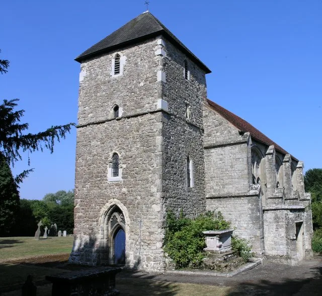
Nettlestead is a village and civil parish on the road southwest of, and part of the borough of Maidstone. The parish includes Nettlestead Green and is part of Seven Mile Lane. More than 800 people live in the parish. The parish church of St Mary the Virgin has links with William the Conqueror's half brother, Odo. Reginald de Pympe, Member of Parliament for Kent in 1411 and 1422, moved into Nettlestead Place, which he rebuilt. He, and his son John, also added new stained glass windows to the parish church. Nettlestead Green is a separate village lying two miles further south. Both villages are close to the River Medway. Wateringbury is immediately to the north.
Excerpt from Wikipedia under CC BY-SA 4.0. See the source article linked in Sources below.
- Coordinates
- 51.2446, 0.4112
- County
- Kent
- District
- Maidstone
- Parish
- Nettlestead
- Postcode
- ME18 5HS
- Parliamentary constituency
- Weald of Kent
- Population
- 839
- Nearest railway station
- Wateringbury — 1 km
Sources
- wikidata: Q2179824 (CC0)
- wikipedia: Nettlestead, Kent (CC BY-SA 4.0)
- commons: St. Mary the Virgin, Nettlestead (geograph 3599440).jpg (CC BY-SA 4.0)
Other places nearby
Loading nearby places…
Nearby
 📷 5
📷 5Historic churches · London
St Mary's Church, Nettlestead
St Mary's Church, Nettlestead — church in Nettlestead, Kent, England, UK.
 📷 5
📷 5Manor houses · London
Nettlestead Place
Nettlestead Place — a manor in england-london, United Kingdom.
 📷 5
📷 5Heritage railway stations · London
Wateringbury railway station
Wateringbury railway station — a Grade II*-listed railway station in england-london, United Kingdom.
 📷 5
📷 5Watermills · London
The Mill Pottery
The Mill Pottery — Grade II listed building-listed watermill in england-london, United Kingdom.
 📷 5
📷 5Memorials & monuments · London
Wateringbury War Memorial Cross
Wateringbury War Memorial Cross — Grade II listed building-listed memorial in england-london, United Kingdom.
 📷 5
📷 5Castles · London
Mereworth Castle
Mereworth Castle — a castle in england-london, United Kingdom.
More towns in this region
 Flagship📷 10
Towns & cities · London
Aldenham
Aldenham — village and civil parish in Hertfordshire, England.
 Flagship📷 10
Towns & cities · London
Ashdon
Ashdon — village and civil parish in Essex, UK.
 Flagship📷 10
Towns & cities · London
Betchworth
Betchworth — village and civil parish in the Mole Valley district of Surrey, England.
 Flagship📷 10
Towns & cities · London
Boxley
Boxley — village and civil parish in Maidstone District, Kent, England, UK.
Frequently asked questions
- Where is Nettlestead?
- Nettlestead is in Kent, London, United Kingdom (postcode ME18 5HS), in the parish of Nettlestead.
- Is Nettlestead a protected site?
- Yes — Nettlestead is part of the Kent Downs National Landscape (AONB).
- Is Nettlestead free to visit?
- Yes, Nettlestead is free to enter.
- How do I get to Nettlestead?
- The nearest railway station is Wateringbury, about 1.0 km away. Drivers can navigate to postcode ME18 5HS.