Mountains & hills · South Wales
Mynydd Llangatwg
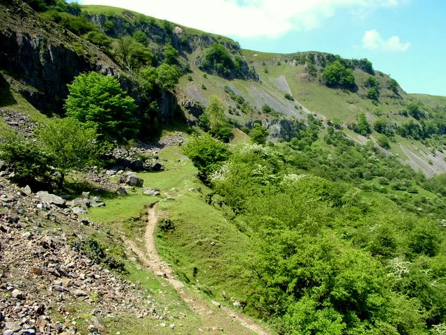
Mynydd Llangatwg — Named summit at 530 m.

Wikimedia Commons contributors — see linked file page for photographer and licence licence
Plan your visit
- Typical visit
- 3 h–8 h
- Best time of year
- Late spring – early autumn (May–Oct)
- Nearest railway station
- Ebbw Vale Town · 5.6 km
- Free entry
- Dog-friendly
About
Mynydd Llangatwg is a named summit in the United Kingdom. Wikidata describes it as: "Named summit at 530 m.". Coordinates: 51.8260°, -3.1855°.
Photo gallery
From the Wikipedia article
Mynydd Llangatwg or Llangattock Mountain is a hill in the Brecon Beacons National Park mostly in the county of Powys, south Wales but also extending into both Monmouthshire and Blaenau Gwent. It is named from the village of Llangatwg (or 'Llangattock') which sits in the valley of the River Usk to the north of it. It is essentially an undulating plateau rising in the west to a height of 530 metres (1,740 ft) at grid reference SO171157 and in the east to a height of 529 metres (1,736 ft) at Hen Dy-aderyn / Twr Pen-cyrn. This latter spot is marked by a trig point. The shallow pool of Pwll Gwy-rhoc sits in a broad depression towards the northern edge of the plateau whilst a smaller pool frequently occupies a large shakehole a few hundred metres to its west. The hill forms an impressive northern scarp overlooking the Usk valley and commonly referred to as the Llangattock Escarpment. Its southern margins are more subdued. Its eastern end is defined by the drops into the Clydach Gorge. Beyond the B4560 to the west the hill merges with Mynydd Llangynidr which has a similar character. Particular features of note include 'The Lonely Shepherd', an isolated limestone pinnacle which stands at the eastern tip of the plateau, left there by quarryworkers who removed great quantities of the surrounding rock. A number of cairns are scattered across the hill, notably the sizeable pair which decorate the summit of Twr Pen-cyrn and which are thought to be of Neolithic age. Some freshwater ponds litter the mountain, including Pwll Gwy-rhoc the "witches' pool". A more recent addition to the landscape was Cairn-Mound Reservoir which once impounded the headwaters of Nant yr Hafod on the southern slopes. Welsh Water abandoned this some years ago and its bed has revegetated, though the embankment remains. A couple of gas pipelines have been laid across the mountain and their courses can be traced variously by fences, vegetation changes and marker poles.
Excerpt from Wikipedia under CC BY-SA 4.0. See the source article linked in Sources below.
Background
Visiting
The B4560 road from Garnllydan to Llangynidr cuts across the high moorland and offers the easiest access to the hill and to Mynydd Llangynidr to its west. Almost the entire hill is designated as urban common and was mapped as open country under the provisions of the Countryside and Rights of Way Act 2000 and therefore freely available for walkers to roam at will. There are few defined paths though a public footpath crosses from north to south passing just east of the top known as Twr Pen-cyrn. The former tramways mentioned above also provide easy level access around the margins of the hill.
Sourced from Wikipedia under CC BY-SA 4.0.
- Coordinates
- 51.8260, -3.1855
- District
- Blaenau Gwent
- Parish
- Brynmawr
- Postcode
- NP23 4SP
- Parliamentary constituency
- Blaenau Gwent and Rhymney
- Nearest railway station
- Ebbw Vale Town — 5.6 km
Sources
- osm: n1537395547 (ODbL)
- wikipedia: Mynydd Llangatwg (CC BY-SA 4.0)
- commons: View across Mynydd Llangatwg - geograph.org.uk - 275832.jpg (CC BY-SA 4.0)
Other places nearby
Loading nearby places…
Nearby
 📷 5
📷 5Caves · South Wales
Agen Allwedd
Agen Allwedd — a cave broad in wales-south, United Kingdom.
 📷 3
📷 3Caves · South Wales
Agen Allwedd (Ogof Gam)
Agen Allwedd (Ogof Gam) is a cave in the United Kingdom.
 📷 3
📷 3Caves · South Wales
Eglwys Faen (Main Entrance)
Eglwys Faen (Main Entrance) is a cave in the United Kingdom.
 📷 5
📷 5Caves · South Wales
Eglwys Faen
Eglwys Faen — a cave broad in wales-south, United Kingdom.
 📷 3
📷 3Natural landmarks · South Wales
Craig y Cilau
Craig y Cilau — mountain in United Kingdom.
Vineyards · South Wales
Coed Pentwyn
Coed Pentwyn — a UK vineyard in wales south, producing English or Welsh wine from cool-climate grape varieties.
More mountains in this region
 Flagship📷 3
Mountains & hills · South Wales
Milford Haven Waterway
Milford Haven Waterway — ria, or flooded valley, in Pembrokeshire, south-west Wales, UK.
 📷 5
📷 5Mountains & hills · South Wales
Ogof Ffynnon Ddu
Ogof Ffynnon Ddu — cave in the Upper Swansea Valley in South Wales.
 📷 3
📷 3Mountains & hills · South Wales
Abereiddi Bay
Abereiddi Bay — bay in the United Kingdom.
 📷 3
📷 3Mountains & hills · South Wales
Allt Lwyd
Allt Lwyd — Named summit at 653 m.
Frequently asked questions
- Where is Mynydd Llangatwg?
- Mynydd Llangatwg is in South Wales, United Kingdom (postcode NP23 4SP), in the parish of Brynmawr.
- Is Mynydd Llangatwg free to visit?
- Yes, Mynydd Llangatwg is free to enter.
- How do I get to Mynydd Llangatwg?
- The nearest railway station is Ebbw Vale Town, about 5.6 km away. Drivers can navigate to postcode NP23 4SP.