Archaeological sites · Yorkshire & the Humber
Myers Wood
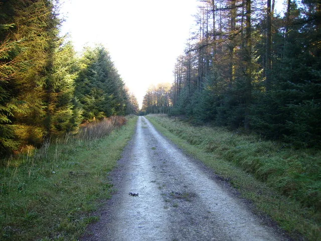
Myers Wood — woodland in Kirkburton, West Yorkshire, England.

Wikimedia Commons contributors — see linked file page for photographer and licence licence
Plan your visit
- Typical visit
- 45 min–1.5 h
- Nearest railway station
- Stocksmoor · 1.7 km
- Free entry
- Dog-friendly
About
Myers Wood is an archaeological site in the United Kingdom. Wikidata describes it as: "woodland in Kirkburton, West Yorkshire, England". Coordinates: 53.6088°, -1.7171°.
Photo gallery
From the Wikipedia article
Myers Wood is a wooded area in the village of Kirkburton, West Yorkshire, England. It forms part of a heavily forested area to the west of the village, occupying the rise in the valley leading up to Storthes Hall and beyond. It is directly west of the main Penistone Road, opposite Riley. Saville Wood is directly south, close to Thunder Bridge. Local residents consider the wood to be of poor quality due to the absence of woodland management. The wood is significant for the discovery of an iron-working site dating from the Middle Ages. Archaeological excavations by a team from the University of Bradford uncovered the most complete site in the north of England. The Cistercian monastic iron-working site was in operation from the 12th century to the 14th century, using advanced techniques and water power for smelting and smithing iron. The site is not a tourist feature, there being no formal administration or oversight by a heritage body; however, it is possible to access the site via the footpath that runs through Saville Wood.
Excerpt from Wikipedia under CC BY-SA 4.0. See the source article linked in Sources below.
- Coordinates
- 53.6088, -1.7171
- District
- Kirklees
- Parish
- Kirkburton
- Postcode
- HD8 0PG
- Parliamentary constituency
- Ossett and Denby Dale
- Nearest railway station
- Stocksmoor — 1.7 km
Sources
- wikidata: Q6947432 (CC0)
- wikipedia: Myers Wood (CC BY-SA 4.0)
- commons: Myers Wood.jpg (CC BY-SA 4.0)
Other places nearby
Loading nearby places…
Nearby
Mountain bike trails · Yorkshire & the Humber
Dual Slalom
Dual Slalom — a mtb trail in england yorkshire.
 📷 5
📷 5Museums · Yorkshire & the Humber
Kirkburton
Kirkburton — a museum in england-yorkshire, United Kingdom.
 📷 3
📷 3Historic houses · Yorkshire & the Humber
Burton Cross
Burton Cross — a Grade II*-listed historic house in england-yorkshire, United Kingdom.
 📷 3
📷 3Memorials & monuments · Yorkshire & the Humber
Highburton Cross
Highburton Cross is a memorial in the United Kingdom.
 📷 4
📷 4Historic bridges · Yorkshire & the Humber
Thunder Bridge
Thunder Bridge is a historic bridge in the United Kingdom.
 📷 3
📷 3Historic bridges · Yorkshire & the Humber
Woodsome Bridge
Woodsome Bridge — Grade II listed building-listed bridge in england-yorkshire, United Kingdom.
More archaeological sites in this region
 📷 5
📷 5Archaeological sites · Yorkshire & the Humber
Dalby Forest
Dalby Forest — forest in North Yorkshire, England.
 📷 4
📷 4Archaeological sites · Yorkshire & the Humber
Dalton Parlours Roman villa and Iron Age settlement
Dalton Parlours Roman villa and Iron Age settlement — archaeological site in Collingham, Leeds, West Yorkshire, England, UK.
 📷 3
📷 3Archaeological sites · Yorkshire & the Humber
Derventio Brigantum
Derventio Brigantum — Roman fort located at present-day Malton, North Yorkshire, England, UK.
 📷 3
📷 3Archaeological sites · Yorkshire & the Humber
Field system including over 300 clearance cairns and two hut circles at Iron Howe
Field system including over 300 clearance cairns and two hut circles at Iron Howe — archaeological site in Hawnby, Ryedale, England, UK.
Frequently asked questions
- Where is Myers Wood?
- Myers Wood is in Yorkshire & the Humber, in the United Kingdom — coordinates 53.6088°, -1.7171°. The nearest railway station is Stocksmoor, around 1.7 km away.
- Is Myers Wood free to visit?
- Yes — admission to Myers Wood is free.