Natural landmarks · North West England
Muncaster Fell
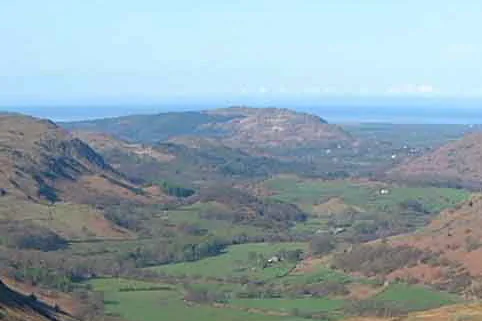
Muncaster Fell — mountain in United Kingdom.

Wikimedia Commons contributors — see linked file page for photographer and licence licence
Plan your visit
- Typical visit
- 1 h–2 h
- Nearest railway station
- Murthwaite Halt · 0.9 km
- Free entry
- Dog-friendly
About
Muncaster Fell is a named natural landmark in the United Kingdom. Wikidata describes it as: "mountain in United Kingdom". Coordinates: 54.3725°, -3.3638°.
Photo gallery
From the Wikipedia article
Muncaster Fell is a fell at the far western edge of the Lake District National Park, in Cumbria, England. Muncaster Fell is a long, narrow ridge of land, approximately 1.2 km wide and 6 km long, lying between the River Mite to the north, and River Esk to the south. The fell rises from the coast near Ravenglass village to its highest point at Hooker Crag (231 m). The ridge then continues to the north-east, dropping gently to its furthest prominence at Silver Knott (174 m). The fell then falls away rapidly to the village of Eskdale Green at its north-eastern tip.
Excerpt from Wikipedia under CC BY-SA 4.0. See the source article linked in Sources below.
- Coordinates
- 54.3725, -3.3638
- District
- Cumberland
- Parish
- Muncaster
- Postcode
- CA18 1SU
- Parliamentary constituency
- Barrow and Furness
- Nearest railway station
- Murthwaite Halt — 0.9 km
Sources
- wikidata: Q6935638 (CC0)
- wikipedia: Muncaster Fell (CC BY-SA 4.0)
- commons: Hardknott Pass and Eskdale crop.jpg (CC BY-SA 4.0)
Other places nearby
Loading nearby places…
Nearby
 📷 3
📷 3Mountains & hills · North West England
Muncaster Fell
Muncaster Fell — Named summit at 232 m.
 📷 3
📷 3Mountains & hills · North West England
Hooker Crag
Hooker Crag — a mountain in england-north-west, United Kingdom.
📷 3Memorials & monuments · North West England
Ross's Camp
Ross's Camp — a memorial in england-north-west, United Kingdom.
 📷 3
📷 3Memorials & monuments · North West England
Muncaster Tower
Muncaster Tower is a memorial in the United Kingdom.
 📷 3
📷 3Memorials & monuments · North West England
Monument North East Of Muncaster Castle
Monument North East Of Muncaster Castle — Grade II listed building-listed memorial in england-north-west, United Kingdom.
Campsites · North West England
Parkgate Farm
Parkgate Farm — a campsite in england north west.
More natural landmarks in this region
 ★ Iconic📷 4
Natural landmarks · North West England
Coniston Water
Lake District lake — Swallows and Amazons setting and Donald Campbell water-speed history.
 📷 3
📷 3Natural landmarks · North West England
Elter Water
Elter Water — lake in the United Kingdom.
 📷 3
📷 3Natural landmarks · North West England
Esthwaite Water
Esthwaite Water — lake in the United Kingdom.
 Flagship📷 5
Natural landmarks · North West England
Semerwater
Semerwater — lake in North Yorkshire, England, UK.
Frequently asked questions
- Where is Muncaster Fell?
- Muncaster Fell is in North-West England, United Kingdom (postcode CA18 1SU), in the parish of Muncaster.
- Is Muncaster Fell free to visit?
- Yes, Muncaster Fell is free to enter.
- How do I get to Muncaster Fell?
- The nearest railway station is Murthwaite Halt, about 0.9 km away. Drivers can navigate to postcode CA18 1SU.