Other places · North East England
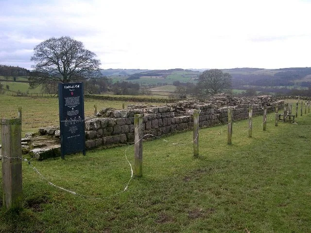
Milecastle 26
Milecastle 26 in England North East, United Kingdom.

Mick Garratt — CC BY-SA 2.0 via Wikimedia Commons licence
Plan your visit
- Typical visit
- 1 h–2 h
About
Milecastle 26 is a place of interest in England North East, United Kingdom — drawn from open-data sources for visitor reference. See the linked Wikipedia article for the full description.
Photo gallery
From the Wikipedia article
Milecastle 26 (Planetrees) was a milecastle of the Roman Hadrian's Wall. Its position is slightly to the south of, but mostly covered by the B6318 Military Road., and it is located around 700 metres (0.43 miles) east of the B6318 Military Road's junction with the A6079. No visible traces exist currently. The dimensions are the same as Milecastles 23, 24, and 25.
Excerpt from Wikipedia under CC BY-SA 4.0. See the source article linked in Sources below.
Background
Architecture
Measuring 15.24 m across, Milecastle 26 was a long-axis milecastle with unknown gateway type. Such milecastles were thought to have been constructed by the Legio VI Victrix who were based in Eboracum (York). A causeway over the wall ditch (not necessarily primary) may have existed at the location of the milecastle. The curtain wall is broad at this point, though changes to narrow gauge between here and Turret 26A, at an extant section of the curtain wall known as Planetrees. Also, in 1956, two iron wedges for splitting stones (260 mm long) were discovered in the rubble and mortar core behind the north facing stones of the wall in a trench cut beside the farm.
Visiting
The sites of Milecastle 26 and Turret 26A are accessible via the Hadrian's Wall National Trail. Turret 26B is accessible from the east side of the A6079, just south of its junction with the B6318 Military Road.
Sourced from Wikipedia under CC BY-SA 4.0.
- Coordinates
- 55.0205, -2.1097
- District
- Northumberland
- Parish
- Wall
- Postcode
- NE46 4EQ
- Parliamentary constituency
- Hexham
- Official site
- www.english-heritage.org.uk
Sources
- wikidata: Q6851163 (CC0)
- wikipedia: Milecastle 26 (CC BY-SA 4.0)
Other places nearby
Loading nearby places…
Nearby
 📷 3
📷 3Hill forts · Scottish Lowlands
Planetrees
Planetrees — section of Hadrian's Wall in north England.
 📷 3
📷 3Archaeological sites · Scottish Lowlands
Planetrees Roman Wall
Planetrees Roman Wall — a archaeological in scotland-lowlands, United Kingdom.
 📷 3
📷 3Wildlife reserves · North East England
Brunton Bank Quarry
Brunton Bank Quarry in England North East, United Kingdom.
 📷 3
📷 3Forts · Scottish Lowlands
Battle of Heavenfield (AD 635)
Battle of Heavenfield (AD 635) is a fort in the United Kingdom.
 📷 4
📷 4Memorials & monuments · Scottish Lowlands
Battle of Heavenfield
Battle of Heavenfield — a memorial in scotland-lowlands, United Kingdom.
 📷 3
📷 3Historic houses · Scottish Lowlands
Medieval cross, 400m south east of Crag House
Medieval cross, 400m south east of Crag House — a Grade II*-listed historic house in scotland-lowlands, United Kingdom.
More places in this region
.jpg?width=1200) 📷 3
📷 3Other places · North East England
Stockton Flyer
Stockton Flyer — Public artwork (installation).
 📷 3
📷 3Other places · North East England
Temenos
Temenos — Public artwork (sculpture) by Anish Kapoor.
 📷 5
📷 5Other places · North East England
Appleby Horse Fair
The Appleby Horse Fair, previously known as Appleby New Fair, is an annual gathering of Romani people (Gypsies) and Travellers in Appleby-in-Westmorland in Cumbria, England. The horse fair is held eac
 📷 5
📷 5Other places · North East England
Locomotion No. 1
Locomotion No. 1 (originally named Active) is an early steam locomotive that was built in 1825 by the pioneering railway engineers George and Robert Stephenson at their manufacturing firm, Robert Step
Frequently asked questions
- Where is Milecastle 26?
- Milecastle 26 is in North East England, in the United Kingdom — coordinates 55.0205°, -2.1097°.
- Who owns Milecastle 26?
- Milecastle 26 is owned by English Heritage.