Mountains & hills · Scottish Highlands
Meall Ghaordaidh
Also known as: Meall Ghaordie
Meall Ghaordaidh — Named summit at 1039 m.

Wikimedia Commons contributors — see linked file page for photographer and licence licence
Plan your visit
- Typical visit
- 3 h–8 h
- Best time of year
- Late spring – early autumn (May–Oct)
- Free entry
- Dog-friendly
About
Meall Ghaordaidh is a named summit in the United Kingdom. Also known as: Meall Ghaordie. Wikidata describes it as: "Named summit at 1039 m.". Coordinates: 56.5258°, -4.4167°.
Photo gallery
From the Wikipedia article
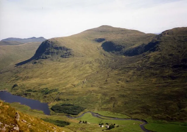
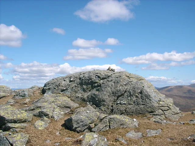
Meall Ghaordaidh is a mountain in the Southern Highlands of Scotland, approximately 10 km north-west of Killin. It is a Munro, recorded as Meall Ghaordie. The mountain can be ascended via Glen Lochay starting to the north-west of the Allt Dhùin Croisg near Duncroisk, via an eroded path leading north-west through peat bogs to the summit; alternatively, an ascent can be made from Glen Lyon starting at Stronuich via one of two spurs that lead to the summit (Creag an Tulabhain or Creag Laoghain). The summit is marked by a large circular rock windbreak, within which there is a trig point.
Excerpt from Wikipedia under CC BY-SA 4.0. See the source article linked in Sources below.
- Coordinates
- 56.5258, -4.4167
- Address
- Stirlingshire, Scotland
- Official site
- www.walkhighlands.co.uk
Sources
- osm: n273933147 (ODbL)
- wikipedia: Meall Ghaordaidh (CC BY-SA 4.0)
- commons: Meall Ghaordaidh.jpg (CC BY-SA 4.0)
Other places nearby
Loading nearby places…
Nearby
 📷 3
📷 3Natural landmarks · Scottish Highlands
Meall Ghaordaidh
Meall Ghaordaidh — 1039m high mountain in Scotland.
 📷 3
📷 3Mountains & hills · Scottish Highlands
Meall na Cnap-laraich
Meall na Cnap-laraich — a mountain in scotland-highlands, United Kingdom.
 📷 3
📷 3Mountains & hills · Scottish Highlands
Meall Ghaordaidh - Creag an Tulabhain
Meall Ghaordaidh - Creag an Tulabhain — a mountain in scotland-highlands, United Kingdom.
 📷 3
📷 3Mountains & hills · Scottish Highlands
Meall Ghaordaidh - Meall Taurnie
Meall Ghaordaidh - Meall Taurnie — a mountain in scotland-highlands, United Kingdom.
 📷 3
📷 3Mountains & hills · Scottish Highlands
Beinn nan Oighreag
Beinn nan Oighreag — Named summit at 909 m.
Vineyards · Scottish Highlands
Caisteal Mhic Neill,ring fort,Glen Lyon
Caisteal Mhic Neill,ring fort,Glen Lyon — a UK vineyard in scotland highlands, producing English or Welsh wine from cool-climate grape varieties.
More mountains in this region
 📷 3
📷 3Mountains & hills · Scottish Highlands
A' Bhuidheanach Bheag
A' Bhuidheanach Bheag — Named summit at 936 m.
 📷 3
📷 3Mountains & hills · Scottish Highlands
A' Chailleach
A' Chailleach — Named summit at 997 m.
 📷 3
📷 3Mountains & hills · Scottish Highlands
A' Chailleach
A' Chailleach — Named summit at 930 m.
 📷 3
📷 3Mountains & hills · Scottish Highlands
A' Chaoirnich
A' Chaoirnich — Named summit at 875 m.
Frequently asked questions
- Where is Meall Ghaordaidh?
- Meall Ghaordaidh is in Scottish Highlands, in the United Kingdom — coordinates 56.5258°, -4.4167°.
- Is Meall Ghaordaidh free to visit?
- Yes — admission to Meall Ghaordaidh is free.