Natural landmarks · Scottish Highlands
Meall Fuar-mhonaidh
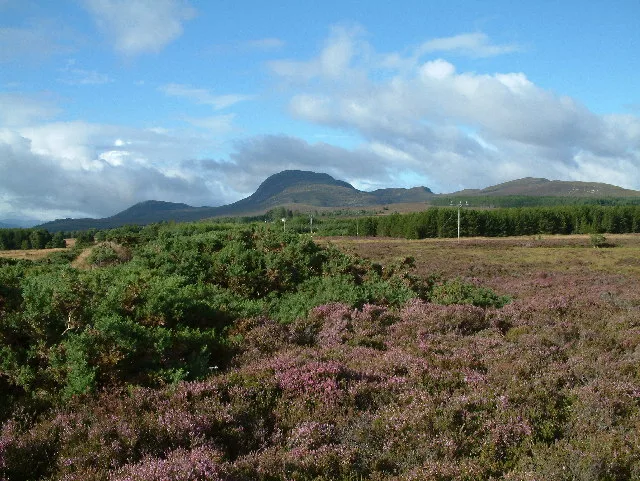
Meall Fuar-mhonaidh — mountain in Highland, Scotland, UK.

Wikimedia Commons contributors — see linked file page for photographer and licence licence
Plan your visit
- Typical visit
- 1 h–2 h
- Free entry
- Dog-friendly
About
Meall Fuar-mhonaidh is a named natural landmark in the United Kingdom. Wikidata describes it as: "mountain in Highland, Scotland, UK". Coordinates: 57.2644°, -4.5601°.
Photo gallery
From the Wikipedia article
Meall Fuar-mhonaidh is a hill on the west side of Loch Ness, in the Highlands of Scotland. At 699 m in height, it is listed as a Graham and a Marilyn. Its rounded shape and prominent position make it a distinctive landmark, visible from along much of Loch Ness. Meall Fuar-mhonaidh is usually climbed from Grotaig, a hamlet at the end of minor road to the south-west of Drumnadrochit. From there a footpath passes through woods, then out onto moorland. This path climbs south-west along the ridge of Meall Fuar-mhonaidh to the summit.
Excerpt from Wikipedia under CC BY-SA 4.0. See the source article linked in Sources below.
- Coordinates
- 57.2644, -4.5601
- Address
- Highland, Scotland
Sources
- wikidata: Q6803529 (CC0)
- wikipedia: Meall Fuar-mhonaidh (CC BY-SA 4.0)
- commons: Meall Fuar-mhonaidh from the Bunloit road - geograph.org.uk - 46917.jpg (CC BY-SA 4.0)
Other places nearby
Loading nearby places…
Nearby
 📷 5
📷 5Mountains & hills · Scottish Highlands
Meall Fuar-mhonaidh
Meall Fuar-mhonaidh — Named summit at 699 m.
 📷 3
📷 3Public art & sculpture · Scottish Highlands
Troll Bridge
Troll Bridge — a public art in scotland-highlands, United Kingdom.
Hostels · Scottish Highlands
The Lochside Hostel
The Lochside Hostel — a hostel in scotland highlands.
 📷 3
📷 3Memorials & monuments · Scottish Highlands
Jane Fraser Memorial Obelisk
Jane Fraser Memorial Obelisk — a memorial in scotland-highlands, United Kingdom.
 📷 3
📷 3Archaeological sites · Scottish Highlands
Dun Scriben
Dun Scriben — a archaeological in scotland-highlands, United Kingdom.
Vineyards · Scottish Highlands
Dun Scriben
Dun Scriben — a UK vineyard in scotland highlands, producing English or Welsh wine from cool-climate grape varieties.
More natural landmarks in this region
 Flagship📷 3
Natural landmarks · Scottish Highlands
Dunalastair Water
Dunalastair Water — lake in Perth and Kinross, Scotland, UK, on the River Tummel.
 Flagship📷 3
Natural landmarks · Scottish Highlands
Loch Arkaig
Loch Arkaig — lake in Highland, Scotland, UK, outflows east to River Arkaig.
 Flagship📷 3
Natural landmarks · Scottish Highlands
Loch Assynt
Loch Assynt — lake in Highland, Scotland, UK, outflows to the River Inver and Loch na Garbh Uidhe.
 Flagship📷 3
Natural landmarks · Scottish Highlands
Loch Awe
Loch Awe — lake in Argyll and Bute, Scotland, UK, outflows to the River Awe.
Frequently asked questions
- Where is Meall Fuar-mhonaidh?
- Meall Fuar-mhonaidh is in Scottish Highlands, in the United Kingdom — coordinates 57.2644°, -4.5601°.
- Is Meall Fuar-mhonaidh free to visit?
- Yes — admission to Meall Fuar-mhonaidh is free.