Towns & cities · South West England
Mark
Mark — village and civil parish in Somerset, UK.

Wikimedia Commons contributors — see linked file page for photographer and licence licence
Plan your visit
- Typical visit
- 3 h–6 h
- Nearest railway station
- Highbridge and Burnham · 5.5 km
- Free entry
- Family-friendly
- Dog-friendly
About
Mark is a town, city, village or settlement in the United Kingdom. Recent population estimates put it at around 1,394 people. Address: TA9. Wikidata describes it as: "village and civil parish in Somerset, UK". Coordinates: 51.2250°, -2.8940°.
Photo gallery
Protected designations
- National Nature Reserve: SOMERSET WETLANDS
- National Nature Reserve: MENDIP
- Area of Outstanding Natural Beauty: Mendip Hills
- Ramsar wetland: Severn Estuary
Designations sourced from Natural England open data under OGL v3.
From the Wikipedia article
Mark is a village and civil parish which lies approximately 10 miles (16 km) from Bridgwater, 5 miles (8 km) from Axbridge, and 4 miles (6.4 km) from Highbridge in the county of Somerset, England. It includes the hamlets of Yarrow and Southwick. The Mark Yeo river has its source near the village. Mark is home to two pubs, a village hall, a village stores and post office, the Ki-Aikido Federation of Great Britain and many clubs and societies, including a Youth Theatre group.
Excerpt from Wikipedia under CC BY-SA 4.0. See the source article linked in Sources below.
Background
History
The origin of the name is believed to mean A boundary of property from the Old English mærc. The estate was given to the Bishop of Wells by Edith of Wessex and with Wedmore was used to endow the deanery of Wells Cathedral by 1157 and continued until 1547. Mark was part of the hundred of Bempstone.
Sourced from Wikipedia under CC BY-SA 4.0.
- Coordinates
- 51.2250, -2.8940
- District
- Somerset
- Parish
- Mark
- Postcode
- TA9
- Parliamentary constituency
- Wells and Mendip Hills
- Population
- 1,394
- Nearest railway station
- Highbridge and Burnham — 5.5 km
- Official site
- www.somersetintelligence.org.uk
Sources
- wikidata: Q1825426 (CC0)
- wikipedia: Mark, Somerset (CC BY-SA 4.0)
- commons: MARK, Somerset - geograph.org.uk - 66003.jpg (CC BY-SA 4.0)
Other places nearby
Loading nearby places…
Nearby
 📷 5
📷 5Historic churches · South West England
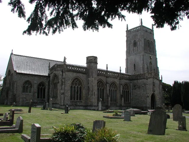
Church of St Mark, Mark
Church of St Mark, Mark — church in Mark, Somerset, England, UK.
Caravan parks · South West England
Coombes Cider Mill Caravan & Camping Park
Coombes Cider Mill Caravan & Camping Park — a caravan park in england south west.
 📷 3
📷 3Farms (open to visitors) · South West England
Rich's Cider Farm
Rich's Cider Farm — a other in england-south-west, United Kingdom.
Caravan parks · South West England
Cripps Farm Holidays
Cripps Farm Holidays — a caravan park in england south west.
 📷 5
📷 5Natural landmarks · South West England
Hill Brow Preparatory School for Boys
Hill Brow Preparatory School for Boys — a school heritage in england-south-west, United Kingdom.
 📷 5
📷 5Museums · South West England
Chapel Allerton, Somerset
Chapel Allerton is a village and civil parish, south of Cheddar in the English county of Somerset. The parish includes the hamlets of Ashton and Stone Allerton.
More towns in this region
 Flagship📷 10
Towns & cities · South West England
All Saints
All Saints — village and civil parish in Devon, England, UK.
 Flagship📷 10
Towns & cities · South West England
Axmouth
Axmouth — village and civil parish in Devon, England, UK.
 ★ Iconic📷 10
Towns & cities · South West England
Beer
Beer — village and civil parish in Devon, UK.
 Flagship📷 10
Towns & cities · South West England
Branscombe
Branscombe — village and civil parish in Devon, UK.
Frequently asked questions
- Where is Mark?
- Mark is in South-West England, United Kingdom (postcode TA9), in the parish of Mark.
- Is Mark a protected site?
- Yes — Mark is part of the SOMERSET WETLANDS National Nature Reserve and the MENDIP National Nature Reserve.
- Is Mark free to visit?
- Yes, Mark is free to enter.
- How do I get to Mark?
- The nearest railway station is Highbridge and Burnham, about 5.5 km away. Drivers can navigate to postcode TA9.