Archaeological sites · North East England
Lune Forest
Lune Forest — forest in County Durham, England, UK.

Wikimedia Commons licence
Plan your visit
- Typical visit
- 45 min–1.5 h
- Free entry
- Dog-friendly
- Limited wheelchair access
About
Lune Forest is an archaeological site in the United Kingdom. Heritage designation: Site of Special Scientific Interest. Wikidata describes it as: "forest in County Durham, England, UK". Coordinates: 54.5833°, -2.2333°.
Protected designations
- Site of Special Scientific Interest: Lune Forest SSSI
- Area of Outstanding Natural Beauty: North Pennines
Designations sourced from Natural England open data under OGL v3.
From the Wikipedia article
Lune Forest is a Site of Special Scientific Interest covering an extensive area of moorland in the Teesdale district of west Durham, England. In the north, where it adjoins the Upper Teesdale and Appleby Fells SSSIs, it extends from Mickle Fell eastward almost as far as Harter Fell, above the hamlet of Thringarth. Its southern limit is marked by the River Balder, upstream from Balderhead Reservoir, where it shares a boundary with Cotherstone Moor SSSI to the south. Grains o' th' Beck Meadows and Close House Mine SSSIs are entirely surrounded by Lune Forest, but do not form part of it. The area has one of the most extensive areas of relatively undisturbed blanket bog in northern England, as well as a number of upland habitats, including wet and dry heath, acid grassland, limestone grassland and flushes. The predominant vegetation is blanket mire, in which heather, Calluna vulgaris, and hare's-tail cottongrass, Eriophorum vaginatum, are co-dominant. On higher ground, to the west, dwarf shrubs such as cloudberry, Rubus chamaemorus, and crowberry, Empetrum nigrum, are more frequent. Where steep slopes have inhibited peat formation, the blanket mire gives way to dry heath, in which heather, wavy hair-grass, Deschampsia flexuosa, and bilberry, Vaccinium myrtillus, are the dominant species. In the northern part of the site, areas where the underlying limestone outcrops at the surface, or has been cut into by small streams, are marked by bands of grassland, typically dominated by mat-grass, Nardus stricta, and with herbs such as heath bedstraw, Galium saxatile, and tormentil, Potentilla erecta. Where the limestone soils are thinner, a more species-rich grassland is found: wild thyme, Thymus praecox, and selfheal, Prunella vulgaris, are common, and in some places there are large populations of spring gentian, Gentiana verna, a nationally rare species that is found nowhere else in Great Britain outside the Teesdale area. The area supports breeding populations of several…
Excerpt from Wikipedia under CC BY-SA 4.0. See the source article linked in Sources below.
- Coordinates
- 54.5833, -2.2333
- District
- County Durham
- Parish
- Lunedale
- Postcode
- DL12 0PB
- Parliamentary constituency
- Bishop Auckland
- Established
- 1998
- Official site
- designatedsites.naturalengland.org.uk
Sources
- wikidata: Q6704176 (CC0)
- wikipedia: Lune Forest (CC BY-SA 4.0)
Featured in these 2 guides
Other places nearby
Loading nearby places…
Nearby
 📷 3
📷 3Reservoirs & lochs · North East England
Foster's Hush
Foster's Hush in England North East, United Kingdom.
 📷 3
📷 3Historic bridges · North East England
Far Beck Bridge
Far Beck Bridge — Grade II listed building-listed bridge in england-north-east, United Kingdom.
 📷 3
📷 3Memorials & monuments · North East England
Crosshill Stone
Crosshill Stone — a memorial in england-north-east, United Kingdom.
📷 3Historic bridges · North East England
Grains O'Th' Beck Bridge
Grains O'Th' Beck Bridge — Grade II listed building-listed bridge in england-north-east, United Kingdom.
 📷 3
📷 3Wildlife reserves · North East England
Close House Mine
Close House Mine in England North East, United Kingdom.
 📷 4
📷 4Wildlife reserves · North East England
Grains o' th' Beck Meadows
Grains o' th' Beck Meadows in England North East, United Kingdom.
More archaeological sites in this region
 ★ Iconic📷 4
Archaeological sites · North East England
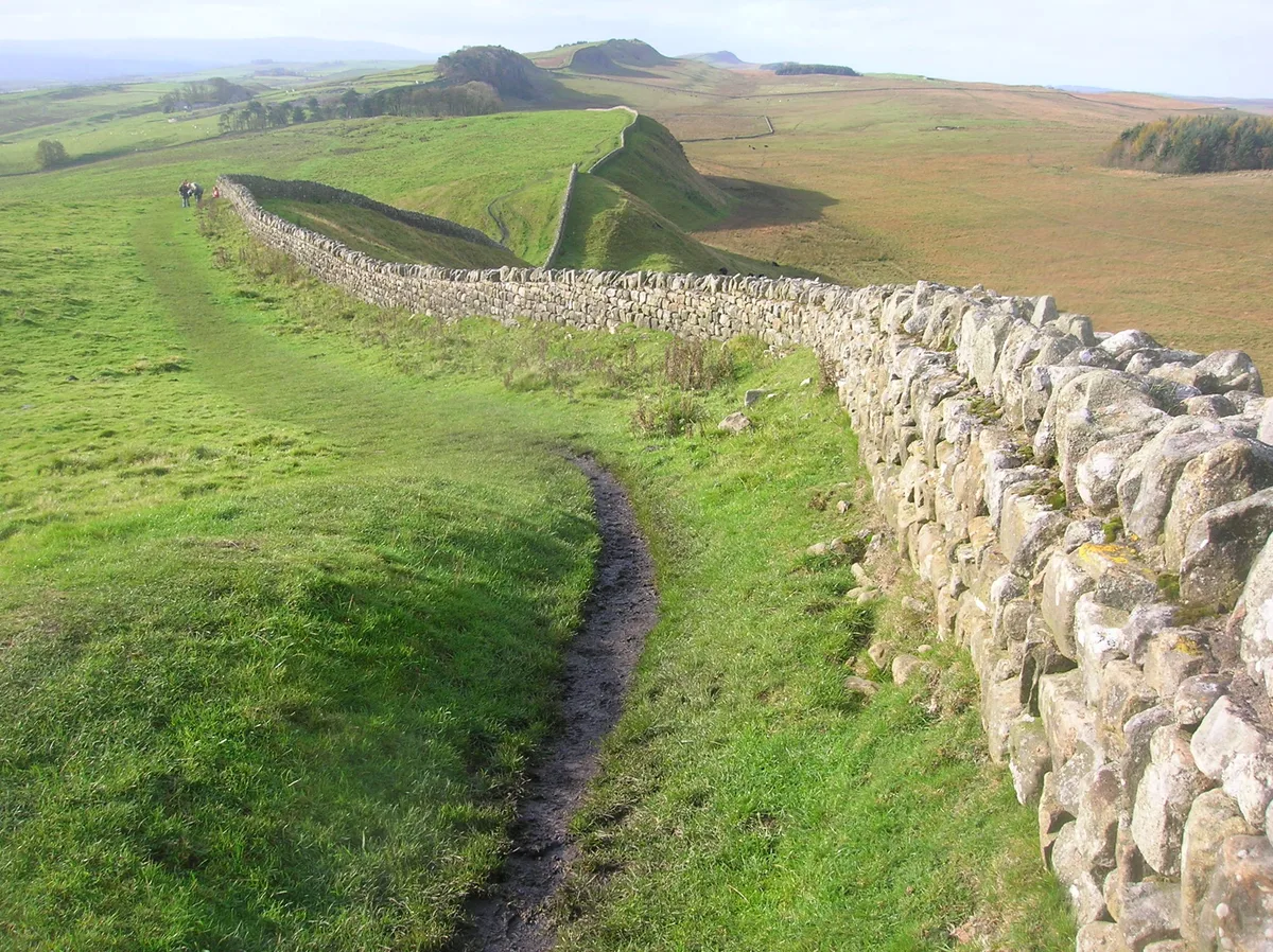
Hadrian's Wall
73-mile UNESCO World Heritage Roman frontier wall — Britain's most extensive Roman monument.
 📷 3
📷 3Archaeological sites · North East England
Force Crag mines and barytes mill and a prehistoric cairnfield
Force Crag mines and barytes mill and a prehistoric cairnfield — archaeological site in Above Derwent, Allerdale, England, UK.
 📷 3
📷 3Archaeological sites · North East England
Gabrosentum Roman Fort
Gabrosentum Roman Fort — Roman fort in Parton, Copeland, England, UK.
 📷 3
📷 3Archaeological sites · North East England
Gisborough Priory Augustinian monastery: late Saxon settlement, cemetery, monastic precinct and dovecote
Gisborough Priory Augustinian monastery: late Saxon settlement, cemetery, monastic precinct and dovecote — archaeological site in Guisborough, Redcar and Cleveland, England, UK.
Frequently asked questions
- Where is Lune Forest?
- Lune Forest is in North-East England, United Kingdom (postcode DL12 0PB), in the parish of Lunedale.
- When was Lune Forest built?
- Built or established in 1998.
- Is Lune Forest a listed building?
- Lune Forest is officially recognised as Site of Special Scientific Interest listed.
- Is Lune Forest a protected site?
- Yes — Lune Forest is part of the Lune Forest SSSI Site of Special Scientific Interest and the North Pennines National Landscape (AONB).
- How do I get to Lune Forest?
- Drivers can navigate to postcode DL12 0PB. It sits within the Bishop Auckland parliamentary constituency.