Reservoirs & lochs · Scottish Highlands
Loch Shin
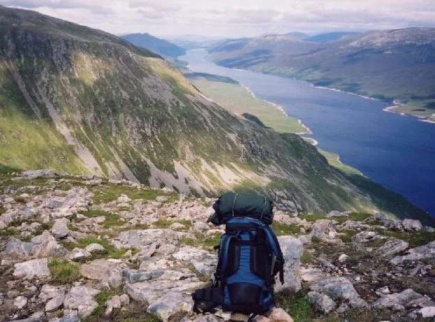
Loch Shin — reservoir in Highland, Scotland, UK, outflows to the River Shin.

Wikimedia Commons contributors — see linked file page for photographer and licence licence
Plan your visit
- Typical visit
- 1 h–2.5 h
- Free entry
- Dog-friendly
About
Loch Shin is a reservoir in the United Kingdom. It covers approximately 23 km². Wikidata describes it as: "reservoir in Highland, Scotland, UK, outflows to the River Shin". Coordinates: 58.1000°, -4.5333°.
Photo gallery
From the Wikipedia article
Loch Shin (Scottish Gaelic: Loch Sìn, pronounced [l̪ˠɔx ˈʃiːn]) is a loch in the Scottish North West Highlands. To the south is the town of Lairg. The loch, the largest in Sutherland, runs from the north-west to the south-east and is 17 miles (27 kilometres) long. In the 1950s, the level of the loch was raised by over 30 feet (9 metres) by the construction of Lairg Dam by Wimpey Construction as part of a hydro-electric scheme. Around the loch there are mountain ranges; the 3,273-foot (998-metre) Ben More Assynt in the west and Ben Klibreck (3,154 ft or 961 m) to the east. The loch drains to the North Sea by way of the short River Shin that feeds into the Dornoch Firth at Bonar Bridge. Three miles to the north of Lairg is a monument in remembrance of an early attempt to tame the Highlands. The area around the loch is a centre for sheep farming in Scotland.
Excerpt from Wikipedia under CC BY-SA 4.0. See the source article linked in Sources below.
- Coordinates
- 58.1000, -4.5333
- Address
- North West Scottish Highlands
Sources
- wikidata: Q430478 (CC0)
- wikipedia: Loch Shin (CC BY-SA 4.0)
- commons: Loch Shin.jpg (CC BY-SA 4.0)
Other places nearby
Loading nearby places…
Nearby
 📷 3
📷 3Other places · Scottish Highlands
Caithness and Sutherland
Caithness and Sutherland in Scotland Islands, United Kingdom.
 📷 3
📷 3Memorials & monuments · Scottish Highlands
Murray Memorial
Murray Memorial — a memorial in scotland-highlands, United Kingdom.
 📷 5
📷 5Forts · Scottish Highlands
Murray Memorial, Shinness
Murray Memorial, Shinness — a martello broad in scotland-highlands, United Kingdom.
📷 4Reservoirs & lochs · Scottish Highlands
Achnairn
Achnairn in Scotland Islands, United Kingdom.
Caravan parks · Scottish Highlands
Woodend Caravan and Camping Site
Woodend Caravan and Camping Site — a caravan park in scotland highlands.
 📷 5
📷 5Historic bridges · Scottish Highlands
Rhian Bridge
Rhian Bridge — category C listed building-listed bridge in scotland-highlands, United Kingdom.
More places in this region
 Flagship📷 3
Reservoirs & lochs · Scottish Highlands
Loch Ericht
Loch Ericht — lake in Perth and Kinross, and Highland, Scotland, UK, outflows to River Ericht.
 📷 3
📷 3Reservoirs & lochs · Scottish Highlands
Allt na Lairige Reservoir
Allt na Lairige Reservoir — 1956 artificial lake in Argyll and Bute, Scotland, UK, on and outflowing west to Allt na Lairige.
.jpg?width=1200) 📷 3
📷 3Reservoirs & lochs · Scottish Highlands
Ardlussa Fishing Loch
Ardlussa Fishing Loch — 1900 artificial lake on Jura, Argyll and Bute, Scotland, UK, on the Lussa River.
 📷 3
📷 3Reservoirs & lochs · Scottish Highlands
Asgog Loch
Asgog Loch — lake dammed as a reservoir in Argyll and Bute, Scotland, UK, outflows east via a watercourse to Allt Osda.
Frequently asked questions
- Where is Loch Shin?
- Loch Shin is in Scottish Highlands, in the United Kingdom — coordinates 58.1000°, -4.5333°.
- Is Loch Shin free to visit?
- Yes — admission to Loch Shin is free.