Natural landmarks · Scottish Highlands
Loch Shiel
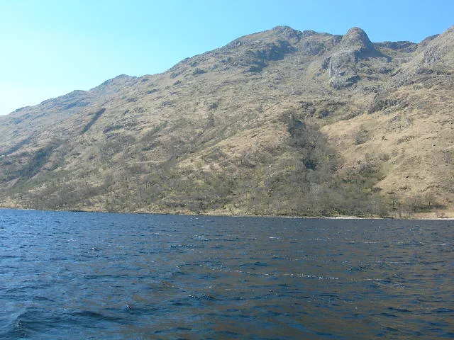
Loch Shiel — freshwater loch in Ardnamurchan, West Highlands of Scotland, UK, outflows to the River Shiel.

Wikimedia Commons contributors — see linked file page for photographer and licence licence
Plan your visit
- Typical visit
- 1 h–2 h
- Free entry
- Dog-friendly
About
Loch Shiel is a named natural landmark in the United Kingdom. It covers approximately 20 km². Wikidata describes it as: "freshwater loch in Ardnamurchan, West Highlands of Scotland, UK, outflows to the River Shiel". Coordinates: 56.7911°, -5.5870°.
Photo gallery
From the Wikipedia article
See Glen Shiel for the much smaller Loch Shiel in Lochalsh. Loch Shiel (Scottish Gaelic: Loch Seile) is a freshwater loch situated 20 kilometres (12 mi) west of Fort William in the Highland council area of Scotland. At 28 kilometres (17+1⁄2 mi) long it is the 4th longest loch in Scotland, and is the longest to have retained a natural outflow without any regulation of its water level, being 120 m (393 ft) deep. Its nature changes considerably along its length, being deep and enclosed by mountains in the north east and shallow surrounded by bog and rough pasture in the south west, from which end the 4 km River Shiel drains to the sea in Loch Moidart near Castle Tioram. The surrounding highlands are picturesque but relatively rarely climbed as none quite reaches the 3,000 ft (910 m) required for Munro status. A number of the hills are classified as Corbetts, including Beinn Resipol, Sgùrr Ghiubhsachain and Sgorr Craobh a' Chaorainn on the southern side of the loch; and Beinn Odhar Bheag on the northern side. The area is well wooded compared to the many Highland areas that have suffered from overgrazing. The view of the loch looking south from the Glenfinnan monument, showing wooded hillsides with bare summits rising steeply from a fjord-like loch, has become one of the most famous images of the Scottish Highlands. Several major films have used the loch for location shooting. Loch Shiel is less than 10 metres above sea level, and was formed at the end of the last ice age when glacial deposits blocked what was formerly a sea loch.
Excerpt from Wikipedia under CC BY-SA 4.0. See the source article linked in Sources below.
Background
History
A ruined medieval chapel found on the largest island, Eilean Fhianain, is dedicated to St. Finan, and may stand on the site of a cell thought to have been built on the island by the saint in the seventh century. The chapel is thought to have been built by Alan MacRuaridh, a chief of Clan Ranald; the clan used the island as a burial place until the end of the sixteenth century. The island continues to be used for burials, and is a Scheduled Ancient Monument. Acharacle, at the south of the Loch, is the site of the 1140 battle in which Somerled defeated the Norse to found the ruling dynasty of Lord of the Isles. During these times, the loch had strategic importance as a communications route…
Visiting
Loch Shiel was the purported secret location of the Black Lake near Hogwarts school in the Harry Potter films. The area was the fictional birthplace of Connor and Duncan MacLeod from the Highlander franchise, and served as the actual location of the boat scene with Ramirez in Highlander (1986). Loch Shiel was also used in the filming of the 1953 movie The Master of Ballantrae starring Errol Flynn.
Sourced from Wikipedia under CC BY-SA 4.0.
- Coordinates
- 56.7911, -5.5870
- Address
- Lochaber, Highland, Scotland
Sources
- wikidata: Q1867298 (CC0)
- wikipedia: Loch Shiel (CC BY-SA 4.0)
- commons: Loch Shiel.jpg (CC BY-SA 4.0)
Other places nearby
Loading nearby places…
Nearby
Vineyards · Scottish Highlands
Rubha an Fhaing Dhuibh,settlement
Rubha an Fhaing Dhuibh,settlement — a UK vineyard in scotland highlands, producing English or Welsh wine from cool-climate grape varieties.
 📷 4
📷 4Reservoirs & lochs · Scottish Islands
Lochaber
Lochaber in Scotland Islands, United Kingdom.
 📷 3
📷 3Natural landmarks · Scottish Highlands
Eas nan Liathanach
Eas nan Liathanach in Scotland Islands, United Kingdom.
 📷 3
📷 3Reservoirs & lochs · Scottish Islands
Polloch
Polloch in Scotland Islands, United Kingdom.
 📷 4
📷 4Historic houses · Scottish Highlands
Corantee Lead Mine
Corantee Lead Mine — a historic house in scotland-highlands, United Kingdom.
 📷 3
📷 3Mountains & hills · Scottish Highlands
Beinn Odhar Bheag
Beinn Odhar Bheag — Named summit at 882 m.
More natural landmarks in this region
 Flagship📷 3
Natural landmarks · Scottish Highlands
Dunalastair Water
Dunalastair Water — lake in Perth and Kinross, Scotland, UK, on the River Tummel.
 Flagship📷 3
Natural landmarks · Scottish Highlands
Loch Arkaig
Loch Arkaig — lake in Highland, Scotland, UK, outflows east to River Arkaig.
 Flagship📷 3
Natural landmarks · Scottish Highlands
Loch Assynt
Loch Assynt — lake in Highland, Scotland, UK, outflows to the River Inver and Loch na Garbh Uidhe.
 Flagship📷 3
Natural landmarks · Scottish Highlands
Loch Awe
Loch Awe — lake in Argyll and Bute, Scotland, UK, outflows to the River Awe.
Frequently asked questions
- Where is Loch Shiel?
- Loch Shiel is in Scottish Highlands, in the United Kingdom — coordinates 56.7911°, -5.5870°.
- Is Loch Shiel free to visit?
- Yes — admission to Loch Shiel is free.