Castles · South West England
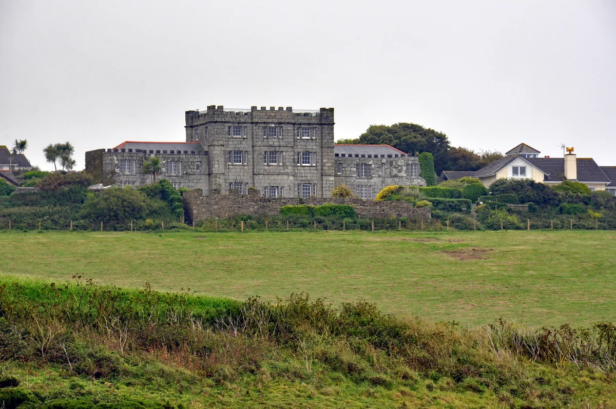
Lescudjack Hill Fort
Lescudjack Hill Fort — Iron Age hillfort in Cornwall, England, UK.

Wikimedia Commons contributors — see linked file page for photographer and licence licence
Plan your visit
- Typical visit
- 1.5 h–3 h
- Nearest railway station
- Penzance · 0.4 km
- Family-friendly
- Limited wheelchair access
About
Lescudjack Hill Fort is a castle in the United Kingdom — fortified architecture from the medieval, Tudor, or Victorian-revival period. Heritage designation: scheduled monument. Wikidata describes it as: "Iron Age hillfort in Cornwall, England, UK". Coordinates: 50.1255°, -5.5335°.
Photo gallery
Heritage listing
Lescudjack Hill fort is the name given to the unexcavated Iron Age settlement located in Penzance, Cornwall. It is positioned on the summit of a steep hill in the east of Penzance and consists of a single rampart enclosing an area of 3 acres (12,000 m2). The site has been damaged and contains allotments and an open area of land which has recently been cleared of thick undergrowth. It is reported that a small lead-copper mine was situated "just outside" the ramparts, however all trace of this appears to have vanished. In 2004 this land was purchased by Penwith District Council and Penzance Town Council for £45,000 following a series of campaigns in the local community including a campaign conducted by the then Lescudjack Infants School (now part of the Pensans Primary School).
From the Historic England List Entry under OGL v3.
Protected designations
- Site of Special Scientific Interest: Aire Point to Carrick Du SSSI
- Site of Special Scientific Interest: West Penwith Moors and Downs SSSI
- Area of Outstanding Natural Beauty: Cornwall
Designations sourced from Natural England open data under OGL v3.
From the Wikipedia article
Lescudjack Hill fort is the name given to the unexcavated Iron Age settlement located in Penzance, Cornwall. It is positioned on the summit of a steep hill in the east of Penzance and consists of a single rampart enclosing an area of 3 acres (12,000 m2). The site has been damaged and contains allotments and an open area of land which has recently been cleared of thick undergrowth. It is reported that a small lead-copper mine was situated "just outside" the ramparts, however all trace of this appears to have vanished. In 2004 this land was purchased by Penwith District Council and Penzance Town Council for £45,000 following a series of campaigns in the local community including a campaign conducted by the then Lescudjack Infants School (now part of the Pensans Primary School). According to Penwith District Council's website, a full archaeological survey is being conducted by Cornwall County Council's Historic Environment Service . The site is also subject to a management plan jointly agreed by Penzance Town Council and Penwith District Council. The site traditionally was referred to as a castle and Castle Road which runs alongside the site was named after it. There are also several roads nearby named Lescudjack, two schools have used the name and the local Sure Start is called Lescudjack. The hill fort was formally handed over to public use on 21 December 2007 as part of the Montol Festival. The fort's name might originate from the Cornish words lan (enclosure) and scosek (shielded)- shielded enclosure or, more likely, "nans" (valley) and "cosek" (wooded); but compare: "lesky" (to burn), "cunnys" (fuel) and "ack" (a place where found) for "LESKInnick" terrace which is just below on the west side of the hill; therefore that could mean a "beacon place".
Excerpt from Wikipedia under CC BY-SA 4.0. See the source article linked in Sources below.
- Coordinates
- 50.1255, -5.5335
- District
- Cornwall
- Parish
- Penzance
- Postcode
- TR18 2BD
- Parliamentary constituency
- St Ives
- Nearest railway station
- Penzance — 0.4 km
Sources
- wikidata: Q6530311 (CC0)
- wikipedia: Lescudjack Hill Fort (CC BY-SA 4.0)
- commons: Lescudjack hillfort - geograph.org.uk - 33402.jpg (CC BY-SA 4.0)
Other places nearby
Loading nearby places…
Nearby
 📷 5
📷 5Towns & cities · South West England
Chyandour
Chyandour — village in Cornwall, United Kingdom.
Campsites · South West England
Ponsandane Camping
Ponsandane Camping — a campsite in england south west.
Cinemas · South West England
Savoy Cinema
Savoy Cinema — a cinema in england south west.
 📷 4
📷 4Public art & sculpture · South West England
Humphry Davy
Humphry Davy — a public art in england-south-west, United Kingdom.
 📷 5
📷 5Gardens · South West England
Market Building, Penzance
Market Building, Penzance — a garden in england-south-west, United Kingdom.
 📷 3
📷 3Theatres · South West England
Theatre, Penzance
Theatre, Penzance — Grade II listed building-listed theatre in england-south-west, United Kingdom.
More castles in this region
 📷 5
📷 5Castles · South West England
Acton Castle
Acton Castle — Cornish historic building.
 📷 5
📷 5Castles · South West England
Affeton Castle
Affeton Castle — castle in East Worlington, Devon, England, UK.
 📷 5
📷 5Castles · South West England
Bayard's Cove Fort
Bayard's Cove Fort — castle in Devon, England, UK.
 📷 5
📷 5Castles · South West England
Berry Pomeroy Castle
Berry Pomeroy Castle — Grade I listed English country house in South Hams, United Kingdom.
Frequently asked questions
- Where is Lescudjack Hill Fort?
- Lescudjack Hill Fort is in South-West England, United Kingdom (postcode TR18 2BD), in the parish of Penzance.
- Who owns Lescudjack Hill Fort?
- Lescudjack Hill Fort is owned by | current_tenants =.
- Is Lescudjack Hill Fort a listed building?
- Lescudjack Hill Fort is officially recognised as scheduled monument listed.
- Is Lescudjack Hill Fort a protected site?
- Yes — Lescudjack Hill Fort is part of the Aire Point to Carrick Du SSSI Site of Special Scientific Interest and the West Penwith Moors and Downs SSSI Site of Special Scientific Interest.
- Does Lescudjack Hill Fort charge admission?
- Lescudjack Hill Fort typically charges admission. Check the official site for current ticket prices and opening hours.
- How do I get to Lescudjack Hill Fort?
- The nearest railway station is Penzance, about 0.4 km away. Drivers can navigate to postcode TR18 2BD.