Towns & cities · South West England
Lelant
Lelant — village in Cornwall, England, UK.

Wikimedia Commons contributors — see linked file page for photographer and licence licence
Plan your visit
- Typical visit
- 3 h–6 h
- Nearest railway station
- Lelant · 0.2 km
- Free entry
- Family-friendly
- Dog-friendly
About
Lelant is a town, city, village or settlement in the United Kingdom. Address: TR26. Wikidata describes it as: "village in Cornwall, England, UK". Coordinates: 50.1840°, -5.4400°.
Photo gallery
Protected designations
- Site of Special Scientific Interest: Hayle Estuary & Carrack Gladden SSSI
- Area of Outstanding Natural Beauty: Cornwall
Designations sourced from Natural England open data under OGL v3.
From the Wikipedia article
Lelant (Cornish: Lannanta) or Uny Lelant is a village in the civil parish of St Ives in, west Cornwall, England, UK. It is on the west side of the Hayle Estuary, about 2+1⁄2 miles (4.0 km) southeast of St Ives and one mile (1.6 km) west of Hayle. The village is part of the Lelant and Carbis Bay ward on Cornwall Council, and also the St Ives Parliamentary constituency. The birth, marriage, and death registration district is Penzance. Its population at the 2011 census was 3,892 The South West Coast Path, which follows the coast of south west England from Somerset to Dorset passes through Lelant, along the estuary and above Porth Kidney Sands.
Excerpt from Wikipedia under CC BY-SA 4.0. See the source article linked in Sources below.
Background
History
]] The name is derived from the Cornish lann and Anta, meaning church-site of Anta. The earliest attested spelling is Lananta in about 1170. Nothing is known about Anta, and Lelant parish church is dedicated to St Uny. However, Carbis Bay church is dedicated to St Anta. Arthur Langdon (1896) records eight stone crosses in the parish, of which four are in the churchyard; the other crosses are at Brunian Cairn, Lelant Lane, Sea Lane and the churchtown. At one time Lelant was an important town and seaport having a market and a custom-house. A parish terrier of 1727 describing the bounds of the glebe land states that about 50 acres of land, and the vicarage, were overwhelmed by sand. The…
Sourced from Wikipedia under CC BY-SA 4.0.
- Coordinates
- 50.1840, -5.4400
- District
- Cornwall
- Parish
- St. Ives
- Postcode
- TR26
- Parliamentary constituency
- St Ives
- Nearest railway station
- Lelant — 0.2 km
Sources
- wikidata: Q431799 (CC0)
- wikipedia: Lelant (CC BY-SA 4.0)
- commons: Lelantrear.jpg (CC BY-SA 4.0)
Other places nearby
Loading nearby places…
Nearby
 📷 3
📷 3Memorials & monuments · South West England
Lelant War Memorial
Lelant War Memorial — Grade II listed building-listed memorial in england-south-west, United Kingdom.
.jpg?width=1200) 📷 3
📷 3Chapels · South West England
Wesleyan Chapel
Wesleyan Chapel — chapel in St. Ives, Cornwall, England, UK.
 📷 5
📷 5Historic churches · South West England
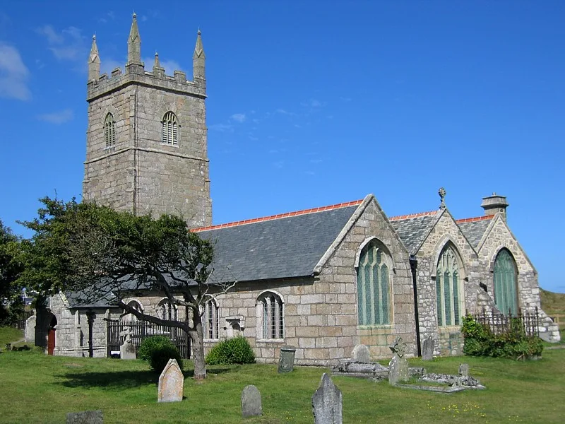
St Uny's Church, Lelant
St Uny's Church, Lelant — church of Lelant, Cornwall, England, UK.
 📷 5
📷 5Museums · South West England
River Hayle
River Hayle — a museum in england-south-west, United Kingdom.
 Flagship📷 10
Zoos & aquariums · South West England
Paradise Park
Paradise Park — wildlife sanctuary in Hayle, Cornwall.
 📷 3
📷 3Miniature railways · South West England
Pardise Railway
Pardise Railway — a miniature railway in england-south-west, United Kingdom.
More towns in this region
 Flagship📷 10
Towns & cities · South West England
All Saints
All Saints — village and civil parish in Devon, England, UK.
 Flagship📷 10
Towns & cities · South West England
Axmouth
Axmouth — village and civil parish in Devon, England, UK.
 ★ Iconic📷 10
Towns & cities · South West England
Beer
Beer — village and civil parish in Devon, UK.
 Flagship📷 10
Towns & cities · South West England
Branscombe
Branscombe — village and civil parish in Devon, UK.
Frequently asked questions
- Where is Lelant?
- Lelant is in South-West England, United Kingdom (postcode TR26), in the parish of St. Ives.
- Is Lelant a protected site?
- Yes — Lelant is part of the Hayle Estuary & Carrack Gladden SSSI Site of Special Scientific Interest and the Cornwall National Landscape (AONB).
- Is Lelant free to visit?
- Yes, Lelant is free to enter.
- How do I get to Lelant?
- The nearest railway station is Lelant, about 0.2 km away. Drivers can navigate to postcode TR26.