Lighthouses · Scottish Lowlands
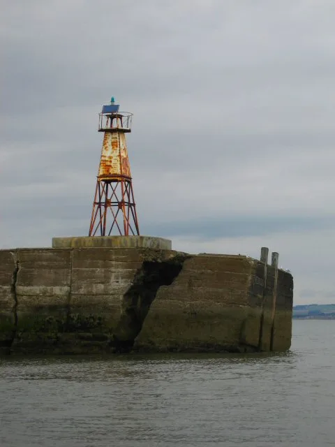
Lees Scar Light
Lees Scar Light is a lighthouse in the United Kingdom.

Wikimedia Commons contributors — see linked file page for photographer and licence licence
Plan your visit
- Typical visit
- 30 min–1 h
- Nearest railway station
- Sillloth Miniature Railway · 3.1 km
- Free entry
- Family-friendly
- Dog-friendly
About
Lees Scar Light is a lighthouse on the coast of the Scottish Lowlands. The site is within the Solway Coast National Landscape (AONB), and is a designated Site of Special Scientific Interest. It sits within the Penrith and Solway parliamentary constituency. The nearest railway station is Sillloth Miniature Railway, about 3.1 km away. Postcode area CA7.
Photo gallery
Protected designations
- Site of Special Scientific Interest: Silloth Dunes and Mawbray Bank SSSI
- Site of Special Scientific Interest: Upper Solway Flats & Marshes SSSI
- Area of Outstanding Natural Beauty: Solway Coast
- Ramsar wetland: Upper Solway Flats & Marshes
Designations sourced from Natural England open data under OGL v3.
Place summary
Lees Scar Light is a lighthouse located in the Scottish Lowlands, within the parish of Silloth-on-Solway (postcode CA7). It is situated in areas designated as SSSIs, including Silloth Dunes and Mawbray Bank, as well as Upper Solway Flats & Marshes, and lies within the Solway Coast Area of Outstanding Natural Beauty (AONB).
AI-generated from the structured facts on this page (operator, designation, listing, era). Not a substitute for visiting.
- Coordinates
- 54.8631, -3.4139
- District
- Cumberland
- Parish
- Silloth-on-Solway
- Postcode
- CA7 4JH
- Parliamentary constituency
- Penrith and Solway
- Nearest railway station
- Sillloth Miniature Railway — 3.1 km
Sources
- wikidata: Q28465900 (CC0)
- commons: Lees Scar Lighthouse - geograph.org.uk - 124373.jpg (CC BY-SA 4.0)
Other places nearby
Loading nearby places…
Nearby
 📷 3
📷 3Hill forts · Scottish Lowlands
Milefortlet 12
Milefortlet 12 — milefortlet of the Roman Cumbrian Coast defences, in Silloth-on-Solway, Allerdale, England, UK.
Campsites · Scottish Lowlands
Stanwix Park holiday Centre
Stanwix Park holiday Centre — a campsite in scotland lowlands.
 📷 3
📷 3Memorials & monuments · Scottish Lowlands
Silloth War Memorial
Silloth War Memorial — Grade II listed building-listed memorial in scotland-lowlands, United Kingdom.
Caravan parks · Scottish Lowlands
Heather Bank
Heather Bank — a caravan park in scotland lowlands.
 📷 3
📷 3Museums · Scottish Lowlands
Toy Soldier Museum
Toy Soldier Museum — a museum in scotland-lowlands, United Kingdom.
 📷 5
📷 5Museums · Scottish Lowlands
Silloth
Silloth — a museum in scotland-lowlands, United Kingdom.
More lighthouses in this region
 📷 3
📷 3Lighthouses · Scottish Lowlands
Ailsa Craig Lighthouse
Ailsa Craig Lighthouse — active 19th century lighthouse located on Ailsa Craig, Scotland.
 📷 3
📷 3Lighthouses · Scottish Lowlands
Amble North Pier light
Amble North Pier light — lighthouse in Northumberland, England.
 📷 3
📷 3Lighthouses · Scottish Lowlands
Amble South Pier light
Amble South Pier light — lighthouse in Northumberland, England.
 📷 3
📷 3Lighthouses · Scottish Lowlands
Blyth East Pier light
Blyth East Pier light — lighthouse in Northumberland, England.
Frequently asked questions
- Where is Lees Scar Light?
- Lees Scar Light is in the Scottish Lowlands, United Kingdom (postcode CA7 4JH), in the parish of Silloth-on-Solway.
- Is Lees Scar Light a protected site?
- Yes — Lees Scar Light is part of the Silloth Dunes and Mawbray Bank SSSI Site of Special Scientific Interest and the Upper Solway Flats & Marshes SSSI Site of Special Scientific Interest.
- Is Lees Scar Light free to visit?
- Yes, Lees Scar Light is free to enter.
- How do I get to Lees Scar Light?
- The nearest railway station is Sillloth Miniature Railway, about 3.1 km away. Drivers can navigate to postcode CA7 4JH.