Natural landmarks · Scottish Lowlands
Kirriereoch Hill
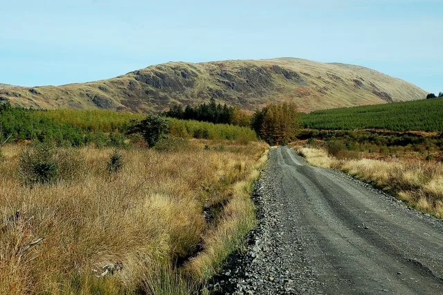
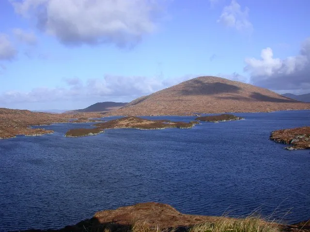
Kirriereoch Hill — 786m high mountain in Scotland.

Wikimedia Commons contributors — see linked file page for photographer and licence licence
Plan your visit
- Typical visit
- 1 h–2 h
- Free entry
- Dog-friendly
About
Kirriereoch Hill is a named natural landmark in the United Kingdom. Wikidata describes it as: "786m high mountain in Scotland". Coordinates: 55.1516°, -4.4796°.
Photo gallery
From the Wikipedia article
Kirriereoch Hill is a hill in the Range of the Awful Hand, a sub-range of the Galloway Hills range, part of the Southern Uplands of Scotland. It lies on the border of the old counties of Ayrshire and Kirkcudbrightshire, or the modern regions of Dumfries and Galloway and South Ayrshire. A boundary wall near the summit is the highest point in South Ayrshire and Ayrshire as a whole. Kirriereoch Hill was classified as a Corbett and Marilyn but then deleted from these lists in 1984 due to not being thought to achieve the respective prominence criteria. In August 2015 the hill was relisted as a Marilyn after having been surveyed to have a 150.2 m prominence. However, since this is less than the 152.4 m required, the hill will not be re-listed as a Corbett. Its current name derives from Kirriereoch farm to its west, as hill in Scots can mean a hillside grazing ground but it was originally recorded in 1654 as "Meal Tuaichtan", a corruption of the original Gaelic name Meall an t-Suachdain. This name was kept for the loch beside the summit, Loch Twachtan (Loch an t-Suachdain).
Excerpt from Wikipedia under CC BY-SA 4.0. See the source article linked in Sources below.
- Coordinates
- 55.1516, -4.4796
- Address
- South Ayrshire, Dumfries and Galloway, Scotland
Sources
- wikidata: Q6416012 (CC0)
- wikipedia: Kirriereoch Hill (CC BY-SA 4.0)
- commons: Along The Track - geograph.org.uk - 1540312.jpg (CC BY-SA 4.0)
Other places nearby
Loading nearby places…
Nearby
 📷 3
📷 3Mountains & hills · Scottish Lowlands
Kirriereoch Hill
Kirriereoch Hill — Named summit at 786 m.
 📷 5
📷 5Mountains & hills · Scottish Lowlands
Merrick
Merrick — Named summit at 843 m.
 📷 5
📷 5Natural landmarks · Scottish Lowlands
Merrick
Merrick — 843m high mountain in Dumfries and Galloway, Scotland, UK.
 📷 4
📷 4Mountains & hills · Scottish Lowlands
Tarfessock
Tarfessock — a mountain in scotland-lowlands, United Kingdom.
 📷 3
📷 3Mountains & hills · Scottish Lowlands
Benyellary
Benyellary — Named summit at 719.3 m.
 📷 3
📷 3Natural landmarks · Scottish Lowlands
Benyellary
Benyellary — mountain in Dumfries and Galloway, Scotland, UK.
More natural landmarks in this region
 Flagship📷 3
Natural landmarks · Scottish Lowlands
Bassenthwaite Lake
Bassenthwaite Lake — lake in Cumbria, England, UK.
 Flagship📷 3
Natural landmarks · Scottish Lowlands
Loch Enoch
Loch Enoch — lake in Dumfries and Galloway, Scotland, UK.
 📷 5
📷 5Natural landmarks · Scottish Lowlands
Annandale Water
Annandale Water — lake in Dumfries and Galloway, Scotland, UK.
 📷 3
📷 3Natural landmarks · Scottish Lowlands
Bakestall
Bakestall — mountain in United Kingdom.
Frequently asked questions
- Where is Kirriereoch Hill?
- Kirriereoch Hill is in Scottish Lowlands, in the United Kingdom — coordinates 55.1516°, -4.4796°.
- Is Kirriereoch Hill free to visit?
- Yes — admission to Kirriereoch Hill is free.