Towns & cities · Central Scotland
Kirknewton
Kirknewton — village in West Lothian, Scotland, UK.

Wikimedia Commons contributors — see linked file page for photographer and licence licence
Plan your visit
- Typical visit
- 3 h–6 h
- Nearest railway station
- Kirknewton · 0.9 km
- Free entry
- Family-friendly
- Dog-friendly
About
Kirknewton is a town, city, village or settlement in the United Kingdom. Recent population estimates put it at around 1,980 people. Wikidata describes it as: "village in West Lothian, Scotland, UK". Coordinates: 55.8877°, -3.4192°.
Photo gallery
From the Wikipedia article
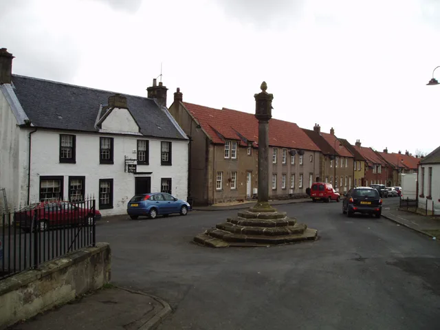
Kirknewton (Scots: Kirknewtoun, Scottish Gaelic: Eaglais a' Bhaile Ùir) is a village formerly in the county of Midlothian and, since 1975, in West Lothian, Scotland. The population of the Kirknewton Community Council district is 2200, which includes the village and surrounding areas. It lies south of the A71 from Edinburgh to Livingston, and north of the A70, the high-level road that runs along the north side of the Pentland Hills from Edinburgh to Carnwath and Lanark. Much of the village stands back from the B7031, which links the two main "A" roads. To the south-east of the village is Morton.
Excerpt from Wikipedia under CC BY-SA 4.0. See the source article linked in Sources below.
Background
History
and Kirk at Kirknewton]] The earliest signs of settlement in the area are the remains of Iron Age forts on Kaimes Hill and Dalmahoy Hill, craggy summits about a mile east of Kirknewton. In slightly more recent times, Kirknewton House, which lies just to the south of the village, had its origins (as Meadowbank House) in the 17th century. The current house is a reworking of the original by the architect William Playfair for Alexander Maconochie, Lord Meadowbank in 1835. Kirknewton House is screened by trees from nearby roads and from the village itself. The most obvious evidence of its existence is the entrance lodge beside the start of the drive to the house at the south end of the village.…
Description
Kirknewton's Main Street has a very enclosed feel. Stretching from the junction with the B7031 to the old kirkyard in the centre of the village, it consists of a collection of one and two storey buildings. At the west end of the village is Kirknewton railway station, officially known as Midcalder Railway Station until 1982. Where the B7031 crosses the railway line at the west end of the station is a level crossing. One accident involving a motor vehicle led to a death and another involving a pedestrian had tragic consequences but the victim did survive. In 2013 the 35-year-old crossing was replaced with double-double barriers. Together with a LIDAR system to ensure trains could not proceed…
Sourced from Wikipedia under CC BY-SA 4.0.
- Coordinates
- 55.8877, -3.4192
- District
- West Lothian
- Postcode
- EH27 8AH
- Parliamentary constituency
- Livingston
- Population
- 1,980
- Nearest railway station
- Kirknewton — 0.9 km
Sources
- wikidata: Q3980 (CC0)
- wikipedia: Kirknewton, West Lothian (CC BY-SA 4.0)
- commons: Manse and Kirk at Kirknewton.jpg (CC BY-SA 4.0)
Other places nearby
Loading nearby places…
Nearby
 📷 3
📷 3Memorials & monuments · Central Scotland
German Air Crew War Memorial
German Air Crew War Memorial — a memorial in scotland-central, United Kingdom.
 📷 3
📷 3Historic houses · Central Scotland
Kirknewton House
Kirknewton House — house in West Lothian, Scotland, UK.
 📷 5
📷 5Historic churches · Central Scotland
Kirknewton Parish Church
Kirknewton Parish Church — category C listed building-listed church in scotland-central, United Kingdom.
 📷 3
📷 3Public art & sculpture · Central Scotland
A Stone's Progress
A Stone's Progress — a public art in scotland-central, United Kingdom.
 📷 3
📷 3Memorials & monuments · Central Scotland
Kirknewton and East Calder War Memorial
Kirknewton and East Calder War Memorial — a memorial in scotland-central, United Kingdom.

Natural landmarks · Central Scotland
Mad Max Adventures
Mad Max Adventures — a other in scotland-central, United Kingdom.
More towns in this region
 Flagship📷 3
Towns & cities · Central Scotland
Airth
Airth — village in Falkirk, Scotland, UK.
 Flagship📷 5
Towns & cities · Central Scotland
Avonbridge
Avonbridge — village in Falkirk, Scotland, UK.
 Flagship📷 3
Towns & cities · Central Scotland
Banknock
Banknock — village in Falkirk, Scotland, UK.
 Flagship📷 3
Towns & cities · Central Scotland
Dundee
Dundee — city in Scotland, UK.
Frequently asked questions
- Where is Kirknewton?
- Kirknewton is in central Scotland, United Kingdom (postcode EH27 8AH).
- Is Kirknewton free to visit?
- Yes, Kirknewton is free to enter.
- How do I get to Kirknewton?
- The nearest railway station is Kirknewton, about 0.9 km away. Drivers can navigate to postcode EH27 8AH.