Towns & cities · Scottish Highlands
Kingswells
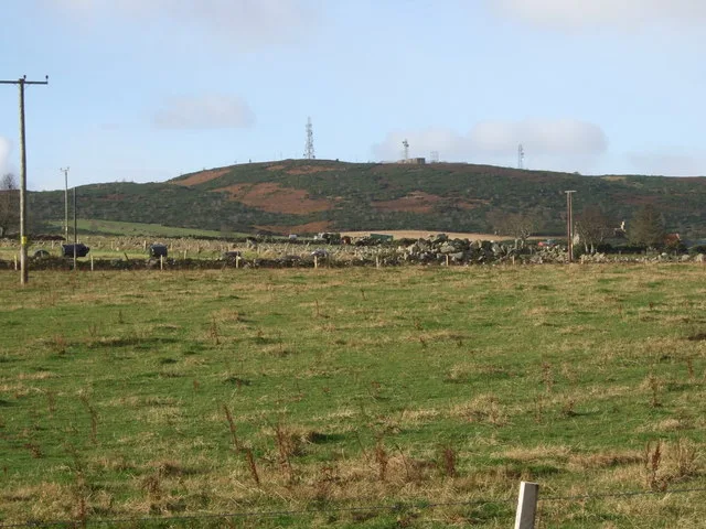
Kingswells — suburb of Aberdeen, Scotland, UK.

Wikimedia Commons contributors — see linked file page for photographer and licence licence
Plan your visit
- Typical visit
- 3 h–6 h
- Nearest railway station
- Dyce · 5.4 km
- Free entry
- Family-friendly
- Dog-friendly
About
Kingswells is a town, city, village or settlement in the United Kingdom. Recent population estimates put it at around 4,740 people. Wikidata describes it as: "suburb of Aberdeen, Scotland, UK". Coordinates: 57.1600°, -2.2231°.
Photo gallery
From the Wikipedia article
Kingswells is a village and suburb of Aberdeen, Scotland, situated west of the city and to the east of Westhill which lies on the other side of the Aberdeen Western Peripheral Route bypass (part of the A90 road). Kingswells has a primary school, a doctor's surgery, a veterinary practice (Ardene), a community centre, a Co-op convenience store, a garage, a beauty salon, and a church. For food and leisure, the village hosts two take-away outlets, a restaurant/café and a pub at the Four Mile. Next to the village lies the Prime Four Business Park, which features offices of many major oil and gas companies, a hotel, gym and Starbucks coffee shop, along with a dentist's surgery. Although Kingswells does not have a secondary school, buses operate regularly, providing transport to nearby secondary schools such as Bucksburn Academy. The village is served by public transport, including the McGill's service 14, which runs between Kingswells and Aberdeen City Centre on weekdays. From the park and ride facility, Stagecoach Bluebird services 5 and 6 connect Kingswells with Westhill and Aberdeen, along with service 218 to Alford and Aberdeen. The area also benefits from easy access to Bridge of Don and Dyce via the AWPR, offering convenience for those working at Aberdeen Airport and nearby industrial estates.
Excerpt from Wikipedia under CC BY-SA 4.0. See the source article linked in Sources below.
- Coordinates
- 57.1600, -2.2231
- District
- Aberdeen City
- Postcode
- AB15 8GD
- Parliamentary constituency
- Aberdeen North
- Population
- 4,740
- Nearest railway station
- Dyce — 5.4 km
Sources
- wikidata: Q1008692 (CC0)
- wikipedia: Kingswells (CC BY-SA 4.0)
- commons: Kingswells, Aberdeen.jpg (CC BY-SA 4.0)
Other places nearby
Loading nearby places…
Nearby
Hotels · Scottish Highlands
Village Hotel Club
Village Hotel Club — a hotel in scotland highlands.
 📷 3
📷 3Memorials & monuments · Scottish Highlands
Kingswells War Memorial
Kingswells War Memorial — a memorial in scotland-highlands, United Kingdom.
📷 5Historic churches · Scottish Highlands
Church Of Scotland, Kingswells, Aberdeen
Church Of Scotland, Kingswells, Aberdeen — category C listed building-listed church in scotland-highlands, United Kingdom.
 📷 3
📷 3Burial mounds & barrows · Scottish Highlands
Longcairn
Longcairn — a burial mound in scotland-highlands, United Kingdom.
 📷 5
📷 5Mountains & hills · Scottish Highlands
Brimmond Hill
Brimmond Hill — Named summit at 266 m.
 📷 5
📷 5Historic churches · Scottish Highlands
Old Parish Church, Newhills
Old Parish Church, Newhills — category B listed building-listed church in scotland-highlands, United Kingdom.
More towns in this region
 Flagship📷 3
Towns & cities · Scottish Highlands
Cruden Bay
Cruden Bay — village in Aberdeenshire, Scotland, UK.
 Flagship📷 3
Towns & cities · Scottish Highlands
Inverness
Inverness — city in the Highlands of Scotland, United Kingdom.
 Flagship📷 3
Towns & cities · Scottish Highlands
Kyle of Lochalsh
Kyle of Lochalsh — village in Highland, Scotland, UK.
 📷 4
📷 4Towns & cities · Scottish Highlands
Aberchirder
Aberchirder — village in Aberdeenshire, Scotland, UK.
Frequently asked questions
- Where is Kingswells?
- Kingswells is in the Scottish Highlands, United Kingdom (postcode AB15 8GD).
- Is Kingswells free to visit?
- Yes, Kingswells is free to enter.
- How do I get to Kingswells?
- The nearest railway station is Dyce, about 5.4 km away. Drivers can navigate to postcode AB15 8GD.