Historic churches · Scottish Highlands
Killearnan
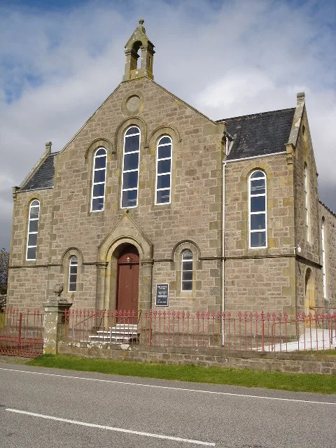
Killearnan in Scotland Islands, United Kingdom.

Julian Paren — CC BY-SA 2.0 via Wikimedia Commons licence
Plan your visit
- Typical visit
- 30 min–1 h
- Free entry
About
Killearnan is a place of interest in Scotland Islands, United Kingdom — drawn from open-data sources for visitor reference. See the linked Wikipedia article for the full description.
Photo gallery
From the Wikipedia article
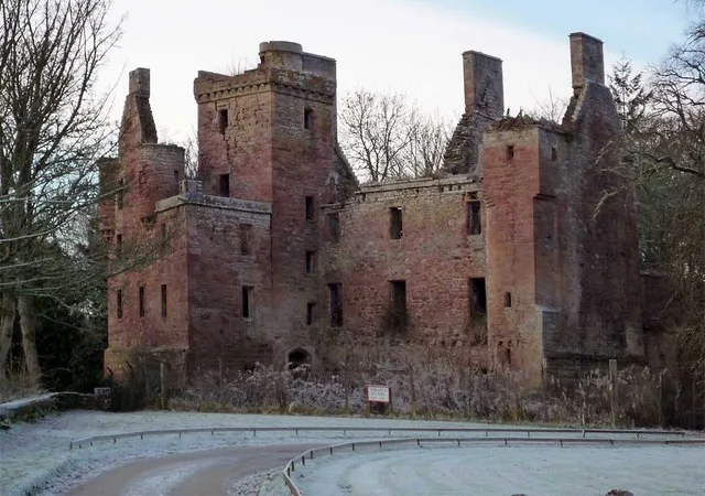
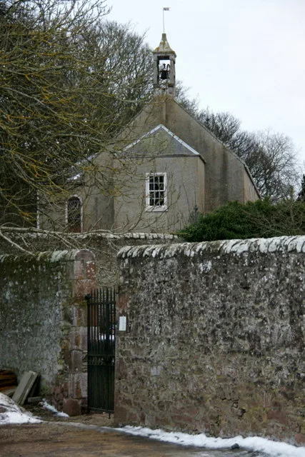
Killearnan is a civil parish in the Black Isle peninsula of Ross and Cromarty in the Highland area of Scotland. It is bordered by the parish of Urquhart and Logie Wester on the north, Urray to the west and Knockbain in the east. It borders the Beauly Firth on the south and its church lies on the banks of that firth. The coastline is 5 miles (8.0 kilometres) and has no marked bay or indentation. The civil parish extends about 8 miles (13 kilometres) from east to west. The name Killearnan means "Iurnan's church" in Gaelic. The parish is mainly rural with no major villages or towns. The land gently rises to 518 feet (158 metres) at Carnurnan, on the northern border with Urquhart and Logie Wester. At the 2011 census, the population of the civil parish was 697. 4.9% had some knowledge of Gaelic. A hundred years before, in 1911, 46.7% were Gaelic speaking (and 52.7% in 1881). The area of the parish is 7,735 acres (12.1 mi2; 31.3 km2). The most significant buildings historically are Redcastle, near the shore of Beauly Firth and Kilcoy Castle in the centre of the parish. Redcastle was built of local Old Red Sandstone on rising ground near the firth. Kilcoy Castle (built early 17th century) was the seat of a barony belonging to the Mackenzie family and has a commanding view of the upper part of the parish. The parish church, west of Redcastle, is also made of local red sandstone and dates from 1450. It was extensively altered in 1892, when the major part of the manse was built. The parish war memorial is sited at the crossroads in Newton about one mile (1.6 km) to the north-east from the church. The small village of Tore in the north-east of the parish has a population of 307 (in 2011) and has a school, hall and other public facilities. Prior to 1891 Torre formed a detached part of the parish of Killearnan, separated from the rest by a strip of Knockbain parish, 280 yards (260 metres) wide at the narrowest. In that year the strip was annexed to Killearnan, uniting the two…
Excerpt from Wikipedia under CC BY-SA 4.0. See the source article linked in Sources below.
- Coordinates
- 57.5130, -4.3740
- District
- Highland
- Postcode
- IV6 7SQ
- Parliamentary constituency
- Caithness, Sutherland and Easter Ross
Sources
- wikidata: Q65515923 (CC0)
- wikipedia: Killearnan (CC BY-SA 4.0)
Other places nearby
Loading nearby places…
Nearby
 📷 5
📷 5Historic churches · Scottish Highlands
Killearnan Parish Church, Milton
Killearnan Parish Church, Milton — category B listed building-listed church in scotland-highlands, United Kingdom.
 📷 3
📷 3Castles · Scottish Highlands
Redcastle
Redcastle — ruined castle in Highland, Scotland, UK.
 📷 3
📷 3Historic houses · Scottish Highlands
Glasshouse
Glasshouse — a historic house in scotland-highlands, United Kingdom.
 📷 3
📷 3Archaeological sites · Scottish Highlands
Redcastle Crannog
Redcastle Crannog — a archaeological in scotland-highlands, United Kingdom.
 📷 5
📷 5Historic bridges · Scottish Highlands
Bridge, Chapelton
Bridge, Chapelton — category B listed building-listed bridge in scotland-highlands, United Kingdom.
 📷 3
📷 3Memorials & monuments · Scottish Highlands
Fettes War Memorial
Fettes War Memorial — a memorial in scotland-highlands, United Kingdom.
More places in this region
 📷 3
📷 3Historic churches · Scottish Highlands
Airlie Parish Kirk
Airlie Parish Kirk — church in Angus, Scotland, UK.
 📷 3
📷 3Historic churches · Scottish Highlands
Arbuthnott, Bervie & Kinneff Parish Church
Arbuthnott, Bervie & Kinneff Parish Church — church in Aberdeenshire, Scotland, UK.
 📷 3
📷 3Historic churches · Scottish Highlands
Arnisdale Free Church
Arnisdale Free Church — church in Highland, Scotland, UK.
 📷 3
📷 3Historic churches · Scottish Highlands
Aultbea Free Church
Aultbea Free Church — church in Aultbea, UK.
Frequently asked questions
- Where is Killearnan?
- Killearnan is in the Scottish Highlands, United Kingdom (postcode IV6 7SQ).
- Is Killearnan free to visit?
- Yes, Killearnan is free to enter.
- How do I get to Killearnan?
- Drivers can navigate to postcode IV6 7SQ. It sits within the Caithness, Sutherland and Easter Ross parliamentary constituency.