Islands · Scottish Highlands
Inchmarnock
Also known as: Innis Mheàrnaig
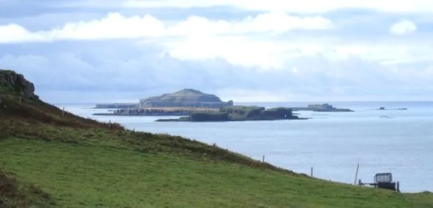
Inchmarnock — island in Argyll and Bute, Scotland, UK.

Wikimedia Commons contributors — see linked file page for photographer and licence licence
Plan your visit
- Typical visit
- 4 h–12 h
- Free entry
- Dog-friendly
About
Inchmarnock is a island in the United Kingdom. Wikidata describes it as: "island in Argyll and Bute, Scotland, UK". Coordinates: 55.7908°, -5.1597°.
Photo gallery
From the Wikipedia article
Inchmarnock (Scottish Gaelic: Innis Mheàrnaig) is an island at the northern end of the Sound of Bute in the Firth of Clyde, on the west coast of Scotland. The island is privately owned.
Excerpt from Wikipedia under CC BY-SA 4.0. See the source article linked in Sources below.
Background
History
The island's name is an anglicisation of the Gaelic Innis Mheàrnaig meaning Island of Marnock. Marnock, (Old Irish M'Ernóc, 'My [i.e. 'Saint'] Little Ernán) was a holy man who lived on the island in the 7th century and established a monastery. Alternatively, the name may simply be a dedication to Ernán and reflect the patron saint the monks on the island followed. He has also lent his name to a number of other locations: At the northern end of the island a Bronze Age cist contains the remains of a female skeleton, the Queen of the Inch. The remains were removed for carbon dating and are now displayed behind a pane of glass in their original position. A report in 2019 stated that the island…
Description
The Inchmarnock Project was a seven-year study, commencing in 1999, of the archaeology and history of the island from the earliest times down to the Improvements of the late 18th and early 19th centuries. It was undertaken by Headland Archaeology and funded by Lord Smith of Kelvin, the owner of Inchmarnock. Within this long chronology of activity some periods are better represented than others, but the highlight of the project was the excavation in and around the medieval church which lies in the stack-yard at Midpark. Excavation to the north of St Marnock's church revealed the remains of what is interpreted as an early monastic enclosure, together with a number of workshops and an…
Sourced from Wikipedia under CC BY-SA 4.0.
- Coordinates
- 55.7908, -5.1597
Sources
- wikidata: Q47941 (CC0)
- wikipedia: Inchmarnock (CC BY-SA 4.0)
- commons: Inchmarnock - geograph.org.uk - 839064.jpg (CC BY-SA 4.0)
Other places nearby
Loading nearby places…
Nearby
 📷 3
📷 3Beaches · Scottish Highlands
St Ninian’s Bay
St Ninian’s Bay is a beach in the United Kingdom.
 📷 3
📷 3Archaeological sites · Scottish Highlands
Clachan Ard, dun
Clachan Ard, dun — a archaeological in scotland-highlands, United Kingdom.
Vineyards · Scottish Highlands
Bute, Dun Scalpsie
Bute, Dun Scalpsie — a UK vineyard in scotland highlands, producing English or Welsh wine from cool-climate grape varieties.
 📷 3
📷 3Archaeological sites · Scottish Highlands
Dun Scalpsie, dun
Dun Scalpsie, dun — a archaeological in scotland-highlands, United Kingdom.
 📷 3
📷 3Beaches · Scottish Highlands
Scalpsie Bay
Scalpsie Bay is a beach in the United Kingdom.
Vineyards · Scottish Highlands
Bute, Loch Quien
Bute, Loch Quien — a UK vineyard in scotland highlands, producing English or Welsh wine from cool-climate grape varieties.
More places in this region
 📷 5
📷 5Islands · Scottish Highlands
Bac Beag
Bac Beag — Scottish island, part of the Treshnish Isles in the Inner Hebrides.
 📷 5
📷 5Islands · Scottish Highlands
Bac Mòr
Bac Mòr — island in Argyll and Bute, Scotland, UK, one of the Treshnish Isles.
 Flagship📷 3
Islands · Scottish Highlands
Baleshare
Baleshare — flat tidal island in the Outer Hebrides, Scotland, UK.
 Flagship📷 5
Islands · Scottish Highlands
Barra
Barra — island in Outer Hebrides, Scotland, UK.
Frequently asked questions
- Where is Inchmarnock?
- Inchmarnock is in Scottish Highlands, in the United Kingdom — coordinates 55.7908°, -5.1597°.
- Is Inchmarnock free to visit?
- Yes — admission to Inchmarnock is free.