Forests & woodlands · London
Hutchinson's Bank
Hutchinson's Bank is a forest or woodland in the United Kingdom.

Wikimedia Commons contributors — see linked file page for photographer and licence licence
Plan your visit
- Typical visit
- 1 h–3 h
- Nearest railway station
- Hayes · 4.7 km
- Free entry
- Family-friendly
- Dog-friendly
About
Hutchinson's Bank is a named forest, woodland or nature reserve in the United Kingdom. Coordinates: 51.3384°, -0.0206°. This entry is part of The Great Britain Guide, a free, ad-free, open-data tourist directory.
Photo gallery
From the Wikipedia article
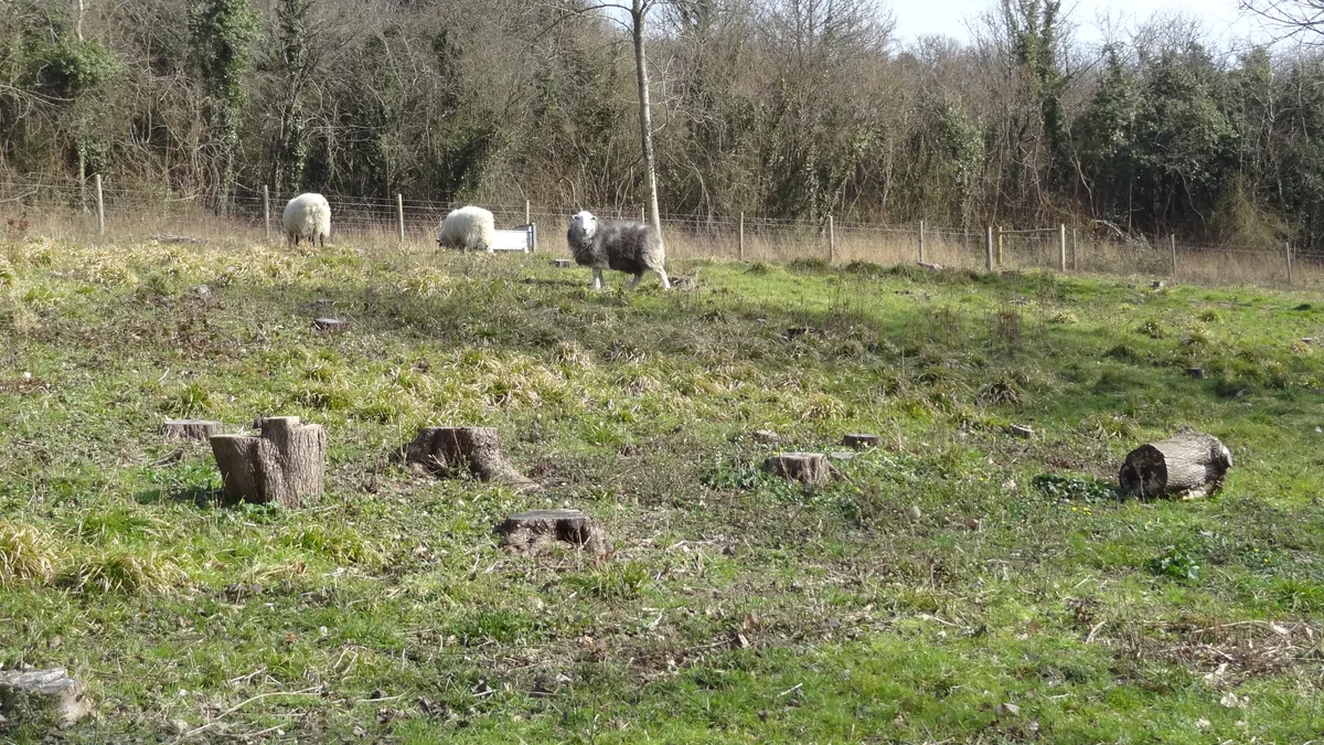
Hutchinson's Bank is 21.8 hectare Local Nature Reserve and Site of Metropolitan Importance for Nature Conservation in New Addington in the London Borough of Croydon. It is owned by Croydon Council and managed by London Wildlife Trust. The site is a sloping dry chalk bank, which has a wide variety of plants, butterflies and birds. Plants include the pyramidal and man orchids, and the greater yellow-rattle, which is rare nationally. Over 100 species of moth and 36 of butterfly have been recorded. It also has scrub with wild privet, dogwood and the wayfaring tree. Sheep graze on the grassland as part of the Surrey Downs Project. There is access from Featherbed Lane, Farleigh Dean Crescent and Thorpe Close.
Excerpt from Wikipedia under CC BY-SA 4.0. See the source article linked in Sources below.
- Coordinates
- 51.3384, -0.0206
- District
- Croydon
- Parish
- Croydon, unparished area
- Postcode
- CR0 9AA
- Parliamentary constituency
- Croydon East
- Nearest railway station
- Hayes — 4.7 km
Sources
- osm: w111204632 (ODbL)
- wikipedia: Hutchinson's Bank (CC BY-SA 4.0)
- commons: Hutchinson's Bank sheep.JPG (CC BY-SA 4.0)
Other places nearby
Loading nearby places…
Nearby
 Flagship📷 10
Wildlife reserves · London
Hutchinson's Bank
Hutchinson's Bank is a wildlife reserve in the United Kingdom.
Campsites · London
Frylands Wood Scout Outdoor Centre
Frylands Wood Scout Outdoor Centre — a campsite in england london.
 📷 5
📷 5Chapels · London
New Addington
New Addington — a methodist chapel in england-london, United Kingdom.
 📷 5
📷 5Country parks · London
Milne Park
Milne Park — urban park in London Borough of Croydon, United Kingdom.
 📷 5
📷 5Parks · London
Addington Vale
Addington Vale — park in London Borough of Croydon.
Campsites · London
Bears Wood Scout Campsite
Bears Wood Scout Campsite — a campsite in england london.
More forests in this region
 📷 5
📷 5Forests & woodlands · London
Ackroyd Drive Green Link
Ackroyd Drive Green Link is a forest or woodland in the United Kingdom.
 📷 5
📷 5Forests & woodlands · London
Adams Road Bird Sanctuary
Adams Road Bird Sanctuary is a forest or woodland in the United Kingdom.
 📷 5
📷 5Forests & woodlands · London
Adelaide Nature Reserve
Adelaide Nature Reserve is a forest or woodland in the United Kingdom.
 📷 5
📷 5Forests & woodlands · London
Angel's Wings
Angel's Wings — Public artwork by Thomas Heatherwick.
Frequently asked questions
- Where is Hutchinson's Bank?
- Hutchinson's Bank is in London, United Kingdom (postcode CR0 9AA), in the parish of Croydon, unparished area.
- Is Hutchinson's Bank free to visit?
- Yes, Hutchinson's Bank is free to enter.
- How do I get to Hutchinson's Bank?
- The nearest railway station is Hayes, about 4.7 km away. Drivers can navigate to postcode CR0 9AA.