Historic houses · South East England
Hungerford Almshouses
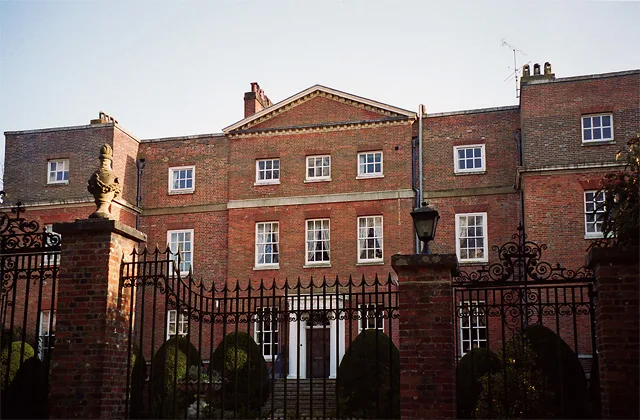
Hungerford Almshouses — a Grade I-listed historic house in england-south-east, United Kingdom.

Brian Robert Marshall — CC BY-SA 2.0 via Wikimedia Commons licence
Plan your visit
- Typical visit
- 1 h–2 h
- Family-friendly
- Limited wheelchair access
About
Hungerford Almshouses is a Grade I-listed building in england-south-east, United Kingdom. Grade I status is conferred by Historic England (or Cadw, Historic Environment Scotland or NIEA equivalents) on buildings of exceptional national interest. See the linked Wikipedia article for full historical and architectural details.
Photo gallery
From the Wikipedia article
The Hungerford Almshouses in Corsham, Wiltshire, England, were built in 1668 for Lady Margaret Hungerford of Corsham Court. It has been designated as a Grade I listed building. The almshouses were founded to provide homes for six (later eight) poor people and education for ten children, on a site on the eastern edge of the town, near the south entrance to Corsham Court. The L-shaped building has six houses for single women along its north-east side, each with a gable and mullioned windows; at the centre is a Baroque carving of the Hungerford arms described as "flamboyant" by Orbach. The west side has the warden's house and a combined schoolroom and chapel, and a full-height porch which is also elaborately embellished. Margaret Hungerford was the daughter of William Holliday, a wealthy London merchant and alderman, and the widow of Sir Edward Hungerford. In 1802, Edward Hasted was given the Mastership of The Hungerford Almshouses by his friend William Bouverie, who had become Earl of Radnor in 1765. Hasted remained Master of the Almshouse from 1807 until his death in 1812. The site, also known as Lady Margaret Hungerford Almshouses & Schoolroom and Corsham Almshouses & 17th Century Schoolroom, is operated as a visitor attraction.
Excerpt from Wikipedia under CC BY-SA 4.0. See the source article linked in Sources below.
- Coordinates
- 51.4350, -2.1825
- District
- Wiltshire
- Parish
- Corsham
- Postcode
- SN13 0BZ
- Parliamentary constituency
- Chippenham
- Established
- 1668
Sources
- wikidata: Q5943339 (CC0)
- wikipedia: Hungerford Almshouses (CC BY-SA 4.0)
Other places nearby
Loading nearby places…
Nearby
 📷 5
📷 5Gardens · South East England
Corsham Court
Corsham Court — Grade I listed English country house in Wiltshire, England, UK.
📷 5Memorials & monuments · South East England
Sweatman Monument In Churchyard About 3 Metres South Of Churchyard North Wall, North Of North Transept Of Church Of St Bartholomew
Sweatman Monument In Churchyard About 3 Metres South Of Churchyard North Wall, North Of North Transept Of Church Of St Bartholomew — Grade II listed building-listed memorial in england-south-east, Uni
📷 5Memorials & monuments · South East England
Unidentified Monument In Churchyard About 9 Metres North Of Wastfield Monument, North Of North Transept Of Church Of St Bartholomew
Unidentified Monument In Churchyard About 9 Metres North Of Wastfield Monument, North Of North Transept Of Church Of St Bartholomew — Grade II listed building-listed memorial in england-south-east, Un
📷 5Memorials & monuments · South East England
Unidentified Monument In Churchyard About 7 Metres North Of Wastfield Monument North Of North Transept Of Church Of St Bartholomew
Unidentified Monument In Churchyard About 7 Metres North Of Wastfield Monument North Of North Transept Of Church Of St Bartholomew — Grade II listed building-listed memorial in england-south-east, Uni
 📷 5
📷 5Memorials & monuments · South East England
Cole Monument In Churchyard About 7 Metres North Of Reynolds Monument, By West Boundary Wall, North Of Church Of St Bartholomew
Cole Monument In Churchyard About 7 Metres North Of Reynolds Monument, By West Boundary Wall, North Of Church Of St Bartholomew — Grade II listed building-listed memorial in england-south-east, United
 📷 5
📷 5Memorials & monuments · South East England
Isaac Monument About 4 Metres South Of North Boundary Wall, In North East Angle Of Churchyard Of Church Of St Bartholomew
Isaac Monument About 4 Metres South Of North Boundary Wall, In North East Angle Of Churchyard Of Church Of St Bartholomew — Grade II listed building-listed memorial in england-south-east, United Kingd
More historic houses in this region
 Flagship📷 9
Historic houses · South East England
Old Arlesford House
Old Arlesford House — country house in Old Alresford, England.
 Flagship📷 10
Historic houses · South East England
Wilbury House
Wilbury House — Grade I listed house in Newton Tony, Wiltshire, England, UK.
 📷 10
📷 10Historic houses · South East England
Woodlands Vale
Woodlands Vale — house in Seaview, Isle of Wight, England, UK.
 📷 5
📷 5Historic houses · South East England
1 South Parade
1 South Parade — Grade I listed house in Bath, Somerset, England, UK.
Frequently asked questions
- Where is Hungerford Almshouses?
- Hungerford Almshouses is in South-East England, United Kingdom (postcode SN13 0BZ), in the parish of Corsham.
- When was Hungerford Almshouses built?
- Built or established in 1668.
- Who owns Hungerford Almshouses?
- Hungerford Almshouses is owned by | designation1 = Grade I Listed Building.
- Is Hungerford Almshouses a listed building?
- Hungerford Almshouses is officially recognised as Grade I listed.
- How do I get to Hungerford Almshouses?
- Drivers can navigate to postcode SN13 0BZ. It sits within the Chippenham parliamentary constituency.