Museums · Yorkshire & the Humber
Haxby
Haxby is a town and civil parish in the City of York, a unitary authority area in the English county of North Yorkshire. According to the 2001 Census, the parish had a population of 8,754, which reduc

Ian S — CC BY-SA 2.0 via Wikimedia Commons licence
Plan your visit
- Typical visit
- 1.5 h–3 h
- Best time of year
- Year-round
- Family-friendly
- Limited wheelchair access
About
Haxby is a town and civil parish in the City of York, a unitary authority area in the English county of North Yorkshire. According to the 2001 Census, the parish had a population of 8,754, which reduced to 8,428 at the 2011 Census. Open farmland extends to the north as far as the villages of Sutton-on-the-Forest and Strensall. The River Foss and Earswick is to the east. It is outside of the York Outer Ring Road (A1237) and near the New Earswick and Huntington areas of York, to the south. It shares a continuous built-up area with the village and parish of Wigginton to the west. Its name is of Old Norse origin with the personal name of Hákr's settlement, in Old Norse bý. It was recorded as Haxebi in the Domesday Book of 1086. Haxby Town Centre, known as "The Village", has been a Conservation Area since 1976. The town's charter was granted in 1992. The Yorkshire village of Haxby was administered by the North Riding County Council and Flaxton Rural District Council until 1974. From 1974 to 1996, Haxby became part of the county of North Yorkshire and Ryedale District. Since 1996 the town of Haxby has been part of the City of York, a unitary authority.
Photo gallery
From the Wikipedia article
Haxby is a town and civil parish in the City of York, a unitary authority area in the English county of North Yorkshire. According to the 2001 Census, the parish had a population of 8,754, which reduced to 8,428 at the 2011 Census. Open farmland extends to the north as far as the villages of Sutton-on-the-Forest and Strensall. The River Foss and Earswick is to the east. It is outside of the York Outer Ring Road (A1237) and near the New Earswick and Huntington areas of York, to the south. It shares a continuous built-up area with the village and parish of Wigginton to the west. Its name is of Old Norse origin with the personal name of Hákr's settlement, in Old Norse bý. It was recorded as Haxebi in the Domesday Book of 1086. Haxby Town Centre, known as "The Village", has been a Conservation Area since 1976. The town's charter was granted in 1992. The Yorkshire village of Haxby was administered by the North Riding County Council and Flaxton Rural District Council until 1974. From 1974 to 1996, Haxby became part of the county of North Yorkshire and Ryedale District. Since 1996 the town of Haxby has been part of the City of York, a unitary authority.
Excerpt from Wikipedia under CC BY-SA 4.0. See the source article linked in Sources below.
Background
History
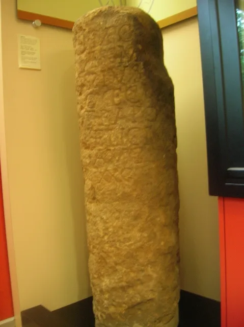
A settlement on the site of the modern town named by the Vikings as Haxebi was established around the 9th century. The Norse word "BY" meant a township or farm and was usually appended to the name of the holder of the lands, in this case a man called Hakr. A Grade III listed Viking cross base in the churchyard of St Mary's Church, and the discovery of a Viking cross shaft in a nearby garden in 1978 support this date. There is evidence of Roman occupation with the 1966 discovery of a site of a Roman villa on Haxby Moor. Roman pottery was found in 2003 on Station Road along with a silver Roman signet ring. the present St Mary's Church and the Methodist Chapel are all important buildings. It…
Sourced from Wikipedia under CC BY-SA 4.0.
- Coordinates
- 54.0158, -1.0719
- District
- York
- Parish
- Haxby
- Postcode
- YO32 3DZ
- Parliamentary constituency
- York Outer
Sources
- wikipedia: Haxby (CC BY-SA 4.0)
Other places nearby
Loading nearby places…
Nearby
 📷 3
📷 3Cemeteries · Yorkshire & the Humber
Haxby and Wigginton Cemetery
Haxby and Wigginton Cemetery is a cemetery in the United Kingdom.
Caravan parks · Yorkshire & the Humber
Earswick Caravan Park
Earswick Caravan Park — a caravan park in england yorkshire.
 📷 4
📷 4Towns & cities · Yorkshire & the Humber
Wigginton
Wigginton — village and civil parish in York, North Yorkshire, England.
Caravan parks · Yorkshire & the Humber
The Lodge
The Lodge — a caravan park in england yorkshire.
Campsites · Yorkshire & the Humber
Willow House Caravan Park
Willow House Caravan Park — a campsite in england yorkshire.
 📷 3
📷 3Theme parks · Yorkshire & the Humber
Web Adventure Park
Web Adventure Park — a theme park in england-yorkshire, United Kingdom.
More museums in this region
 📷 3
📷 3Museums · Yorkshire & the Humber
Aldborough Roman Town
Aldborough Roman Town — Heritage Museum in Yorkshire, England, UK.
 📷 3
📷 3Museums · Yorkshire & the Humber
Bayle Museum
Bayle Museum — Local museum in Bridlington, England.
Museums · Yorkshire & the Humber
BD1 Gallery
BD1 Gallery — closed gallery in Bradford, West Yorkshire.
 📷 5
📷 5Museums · Yorkshire & the Humber
Beck Isle Museum
Beck Isle Museum — museum in Pickering, North Yorkshire, England, United Kingdom.
Frequently asked questions
- Where is Haxby?
- Haxby is in Yorkshire & the Humber, in the United Kingdom — coordinates 54.0158°, -1.0719°.
- Is Haxby wheelchair accessible?
- Partially — OpenStreetMap notes limited wheelchair access at Haxby. Check ahead for specific facilities.