Mountains & hills · North West England
Hawthornthwaite Fell Top
Hawthornthwaite Fell Top — Named summit at 478 m.

Wikimedia Commons contributors — see linked file page for photographer and licence licence
Plan your visit
- Typical visit
- 3 h–8 h
- Best time of year
- Late spring – early autumn (May–Oct)
- Free entry
- Dog-friendly
About
Hawthornthwaite Fell Top is a named summit in the United Kingdom. Wikidata describes it as: "Named summit at 478 m.". Coordinates: 53.9577°, -2.6431°.
Photo gallery
Protected designations
- Site of Special Scientific Interest: Bowland Fells SSSI
- Area of Outstanding Natural Beauty: Forest Of Bowland
Designations sourced from Natural England open data under OGL v3.
From the Wikipedia article
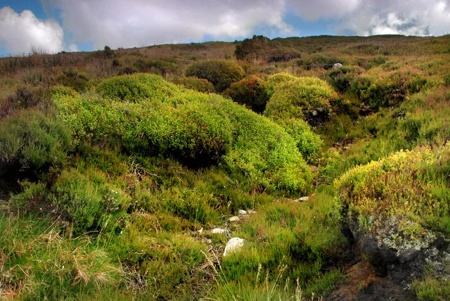
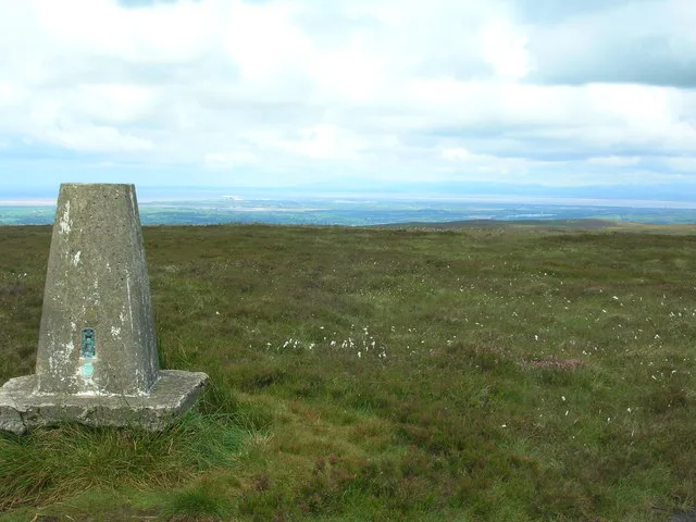
Hawthornthwaite Fell is one of the larger hills in the Forest of Bowland in the north west of England. Hawthornthwaite Fell marks the extreme western limit of the West Riding of the historic county of York. Since 1974 it has fallen within the boundaries of the administrative county of Lancashire. However, most of the hill is on the Duke of Westminster's land. It occupies a north-facing position on the south-western range, close to Bleasdale and Fair Snape Fell. The only path to the summit comes over the hills from the south. The summit is boggy and flanked to the north by steep heather slopes. Grouse are farmed in the area and hen harriers can be seen frequently. The trig point and the remains of its foundations are no longer upright, lying horizontally pointing westward.
Excerpt from Wikipedia under CC BY-SA 4.0. See the source article linked in Sources below.
- Coordinates
- 53.9577, -2.6431
- Address
- Forest of Bowland, England
Sources
- osm: n29544764 (ODbL)
- wikipedia: Hawthornthwaite Fell (CC BY-SA 4.0)
- commons: Slope of Hawthornwaite Fell.jpg (CC BY-SA 4.0)
Other places nearby
Loading nearby places…
Nearby
 📷 3
📷 3Natural landmarks · North West England
Hawthornthwaite Fell
Hawthornthwaite Fell — mountain in the United Kingdom.
 📷 3
📷 3Towns & cities · North West England
Abbeystead
Abbeystead — village in Lancashire, England, UK.
 📷 4
📷 4Abbeys & priories · North West England
Abbeystead House
Abbeystead House — a Grade II*-listed abbey in england-north-west, United Kingdom.
 📷 3
📷 3Historic bridges · North West England
Stoops Bridge
Stoops Bridge — Grade II listed building-listed bridge in england-north-west, United Kingdom.
 📷 3
📷 3Mountains & hills · North West England
Hazelhurst Fell
Hazelhurst Fell — Named summit at 429 m.
 📷 3
📷 3Historic bridges · North West England
Lee Bridge
Lee Bridge — Grade II listed building-listed bridge in england-north-west, United Kingdom.
More mountains in this region
 📷 3
📷 3Mountains & hills · North West England
Allen Crags
Allen Crags — Named summit at 785 m.
 📷 3
📷 3Mountains & hills · North West England
Alum Pot
Alum Pot — Open shaft pothole in North Yorkshire.
 📷 3
📷 3Mountains & hills · North West England
Arnside Knott
Arnside Knott — Named summit at 159 m.
 📷 3
📷 3Mountains & hills · North West England
Aye Gill Pike
Aye Gill Pike — Named summit at 556.3 m.
Frequently asked questions
- Where is Hawthornthwaite Fell Top?
- Hawthornthwaite Fell Top is in North-West England, United Kingdom.
- Is Hawthornthwaite Fell Top a protected site?
- Yes — Hawthornthwaite Fell Top is part of the Bowland Fells SSSI Site of Special Scientific Interest and the Forest Of Bowland National Landscape (AONB).
- Is Hawthornthwaite Fell Top free to visit?
- Yes, Hawthornthwaite Fell Top is free to enter.