Mountains & hills · South West England
Hawk's Tor
Also known as: Torr Hok
Hawk's Tor — Named summit at 329 m.

Wikimedia Commons contributors — see linked file page for photographer and licence licence
Plan your visit
- Typical visit
- 3 h–8 h
- Best time of year
- Late spring – early autumn (May–Oct)
- Nearest railway station
- Mansion House Station · 8.9 km
- Free entry
- Dog-friendly
About
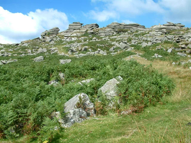
Hawk's Tor is a named summit in the United Kingdom. Also known as: Torr Hok. Wikidata describes it as: "Named summit at 329 m.". Coordinates: 50.5606°, -4.4668°.
Photo gallery
Protected designations
- Area of Outstanding Natural Beauty: Cornwall
Designations sourced from Natural England open data under OGL v3.
From the Wikipedia article
Hawk's Tor is an elongated hill, 329 metres (1,079 ft) high and running from WSW to ENE, on Bodmin Moor in the county of Cornwall, England, UK. It stands opposite the village of North Hill across the valley of the River Lynher. There is another Hawk's Tor (307 m) on Bodmin Moor, further west, near the village of Blisland.
Excerpt from Wikipedia under CC BY-SA 4.0. See the source article linked in Sources below.
- Coordinates
- 50.5606, -4.4668
- District
- Cornwall
- Parish
- North Hill
- Postcode
- PL15 7PE
- Parliamentary constituency
- North Cornwall
- Nearest railway station
- Mansion House Station — 8.9 km
Sources
- osm: n1888808251 (ODbL)
- wikipedia: Hawk's Tor, North Hill (CC BY-SA 4.0)
- commons: Hawk's Tor.jpg (CC BY-SA 4.0)
Other places nearby
Loading nearby places…
Nearby
Vineyards · South West England
Allabury Camp slight univallate hillfort 425m WNW of West Castick Farm
Allabury Camp slight univallate hillfort 425m WNW of West Castick Farm — a UK vineyard in england south west, producing English or Welsh wine from cool-climate grape varieties.

Archaeological sites · South West England
Allabury
Allabury — a archaeological in england-south-west, United Kingdom.
 📷 3
📷 3Historic bridges · South West England
Bridge 270 Metres To North West Of West Castick Farm
Bridge 270 Metres To North West Of West Castick Farm — Grade II listed building-listed bridge in england-south-west, United Kingdom.
 📷 5
📷 5Mountains & hills · South West England
Kilmar Tor
Kilmar Tor — Named summit at 397 m.
 📷 3
📷 3Historic bridges · South West England
Bridge 170 Metres To South East Of Treveniel Farm
Bridge 170 Metres To South East Of Treveniel Farm — Grade II listed building-listed bridge in england-south-west, United Kingdom.
Vineyards · South West England
Medieval settlement and field system south of Tresellern Farm, incorporating Prehistoric hut circle settlements
Medieval settlement and field system south of Tresellern Farm, incorporating Prehistoric hut circle settlements — a UK vineyard in england south west, producing English or Welsh wine from cool-climate grape varieties.
More mountains in this region
 📷 5
📷 5Mountains & hills · South West England
Alex Tor
Alex Tor — Named summit at 291 m.
 📷 5
📷 5Mountains & hills · South West England
Ash Hole Cavern
Ash Hole Cavern — cave in Brixham, Devon, England, UK.
 📷 5
📷 5Mountains & hills · South West England
Babbacombe Bay
Babbacombe Bay — bay in Devon, England.
 📷 5
📷 5Mountains & hills · South West England
Barley Bay
Barley Bay — bay in the United Kingdom.
Frequently asked questions
- Where is Hawk's Tor?
- Hawk's Tor is in South-West England, United Kingdom (postcode PL15 7PE), in the parish of North Hill.
- Is Hawk's Tor a protected site?
- Yes — Hawk's Tor is part of the Cornwall National Landscape (AONB).
- Is Hawk's Tor free to visit?
- Yes, Hawk's Tor is free to enter.
- How do I get to Hawk's Tor?
- Drivers can navigate to postcode PL15 7PE. It sits within the North Cornwall parliamentary constituency.