Towns & cities · West Midlands
Harlaston
Harlaston — village and civil parish in Staffordshire, UK.

Wikimedia Commons contributors — see linked file page for photographer and licence licence
Plan your visit
- Typical visit
- 3 h–6 h
- Nearest railway station
- Statfold Junction · 5.2 km
- Free entry
- Family-friendly
- Dog-friendly
About
Harlaston is a town, city, village or settlement in the United Kingdom. Recent population estimates put it at around 378 people. Address: B79. Wikidata describes it as: "village and civil parish in Staffordshire, UK". Coordinates: 52.6960°, -1.6830°.
Photo gallery
Protected designations
- Site of Special Scientific Interest: River Mease SSSI
Designations sourced from Natural England open data under OGL v3.
From the Wikipedia article
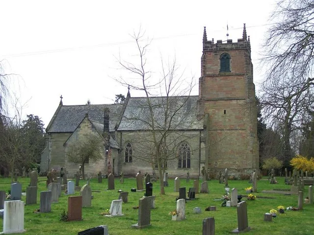
Harlaston is a village and civil parish in Staffordshire, England. It lies on the River Mease, about 5 miles (8 km) north of Tamworth. There is an Early English church, dedicated to St Matthew, and a public house, the White Lion. Harlaston is a conservation area, and has won the Staffordshire Best Kept Small Village award 5 times.
Excerpt from Wikipedia under CC BY-SA 4.0. See the source article linked in Sources below.
Background
History
The name Harlaston comes from Old English, and means either Heoruwulfs farm or Heorulafs farm. It has been suggested that the church goes back to the 11th century and is of Anglo-Saxon origin. Certainly, a corn mill is mentioned in the Domesday Book. Until 1845 Harlaston was a chapelry of the parish of Clifton Campville, after which date it became an independent ecclesiastical parish. In 1851 the population was 221, on about 1400 acres of land. There were 2 lords of the manor, Captain Theophilus Levett and W Chettle, though much of the land belonged to other people.
Sourced from Wikipedia under CC BY-SA 4.0.
- Coordinates
- 52.6960, -1.6830
- County
- Staffordshire
- District
- Lichfield
- Parish
- Harlaston
- Postcode
- B79
- Parliamentary constituency
- Tamworth
- Population
- 378
- Nearest railway station
- Statfold Junction — 5.2 km
- Official site
- www.harlaston.org.uk
Sources
- wikidata: Q1857779 (CC0)
- wikipedia: Harlaston (CC BY-SA 4.0)
- commons: St Matthew, Harlaston.jpg (CC BY-SA 4.0)
Other places nearby
Loading nearby places…
Nearby
 📷 3
📷 3Historic bridges · West Midlands
Elford Bridge East
Elford Bridge East — Grade II listed building-listed bridge in england-west-midlands, United Kingdom.
 📷 3
📷 3Historic churches · West Midlands
St Peter's Church, Elford
St Peter's Church, Elford — church in Elford, Staffordshire, England, UK.
 📷 5
📷 5Museums · East Midlands
River Mease
River Mease — a museum in england-east-midlands, United Kingdom.
 📷 3
📷 3Historic houses · East Midlands
Croxall Hall
Croxall Hall is a historic house in the United Kingdom.
 📷 4
📷 4Historic churches · West Midlands
Church of St Andrew, Clifton Campville
Church of St Andrew, Clifton Campville — church in Clifton Campville, Staffordshire, England, UK.
 📷 4
📷 4Historic bridges · East Midlands
Chetwynd Bridge
Chetwynd Bridge — Grade II* listed building-listed bridge in england-east-midlands, United Kingdom.
More towns in this region
 Flagship📷 3
Towns & cities · West Midlands
Adderbury
Adderbury — village and civil parish in Cherwell district, Oxfordshire, England.
 Flagship📷 3
Towns & cities · West Midlands
Admington
Admington — village in Warwickshire, England, UK.
 Flagship📷 3
Towns & cities · West Midlands
Aldington
Aldington — village in Worcestershire, United Kingdom.
 Flagship📷 5
Towns & cities · West Midlands
Anstey
Anstey — large village in Leicestershire, England.
Frequently asked questions
- Where is Harlaston?
- Harlaston is in Staffordshire, the West Midlands, United Kingdom (postcode B79), in the parish of Harlaston.
- Is Harlaston a protected site?
- Yes — Harlaston is part of the River Mease SSSI Site of Special Scientific Interest.
- Is Harlaston free to visit?
- Yes, Harlaston is free to enter.
- How do I get to Harlaston?
- The nearest railway station is Statfold Junction, about 5.2 km away. Drivers can navigate to postcode B79.