Archaeological sites · North Wales
Gwydir Forest
Also known as: Coedwig Gwydyr
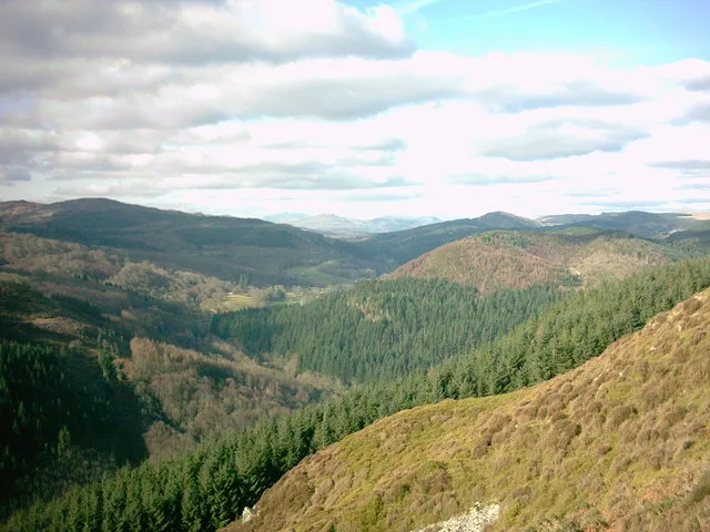
Gwydir Forest — forest in Conwy County Borough, Wales.

Wikimedia Commons contributors — see linked file page for photographer and licence licence
Plan your visit
- Typical visit
- 45 min–1.5 h
- Nearest railway station
- Gogledd Llanrwst / North Llanrwst · 2.6 km
- Free entry
- Dog-friendly
About
Gwydir Forest is an archaeological site in the United Kingdom. Wikidata describes it as: "forest in Conwy County Borough, Wales". Coordinates: 53.1260°, -3.8280°.
Photo gallery
From the Wikipedia article
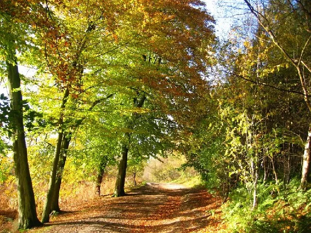
Gwydir Forest, also spelled Gwydyr, is located in Conwy County Borough and the Snowdonia National Park in Wales. It takes its name from the ancient Gwydir Estate, established by the John Wynn family of Gwydir Castle, which owned this area. Natural Resources Wales uses the alternative spelling (i.e. Gwydyr Forest, Coedwig Gwydyr). Certainly as early as 1536, Leland wrote: "Gwydir lieth two bowshots above the River Conwy. It is a pretty place."
Excerpt from Wikipedia under CC BY-SA 4.0. See the source article linked in Sources below.
Background
Description
Today the forest is dotted with the remains of former metal mines: old engine houses, waste tips, reservoirs, and the surface remains of the pits themselves. This, however, is nothing compared to the labyrinth of tunnels below the surface, which run to many miles in length. Predominantly lead and zinc were mined, and the heyday of metal mining in the forest was between 1850 and 1919, although mining on a small scale began in the early 17th century. Indeed, whilst evidence is difficult to find following centuries of subsequent mining work, it is more than likely that a certain amount of shallow mining was undertaken by the Romans—the Roman road of Sarn Helen passed through the forest. The…
Visiting
The land owned by Natural Resources Wales in Snowdonia National Park amounts to just over 12%, and of the four forest areas, the Gwydir Forest is probably the most popular based on visitor numbers. In 1937, Gwydir was designated a National Forest Park, and since 1993 the heartland of the forest has been accorded the special status of Forest Park. Promotion as an attraction has been an integral part of this designation. The forest is very accessible by wide tracks, old miners' paths, and long-established forest walks, a number of which follow waymarked routes. This popularity has further increased in recent years after the construction of the Marin Trail (named after the mountain bike…
Sourced from Wikipedia under CC BY-SA 4.0.
- Coordinates
- 53.1260, -3.8280
- District
- Conwy
- Parish
- Trefriw
- Postcode
- LL27 0YZ
- Parliamentary constituency
- Bangor Aberconwy
- Nearest railway station
- Gogledd Llanrwst / North Llanrwst — 2.6 km
Sources
- wikidata: Q5623753 (CC0)
- wikipedia: Gwydir Forest (CC BY-SA 4.0)
- commons: View from Gwydir Forest.jpg (CC BY-SA 4.0)
Featured in this guide
Other places nearby
Loading nearby places…
Nearby
 📷 3
📷 3Reservoirs & lochs · North Wales
Llyn Glan Gors
Llyn Glan Gors — lake in the Gwydir Forest in north Wales.
 📷 3
📷 3Mountains & hills · North Wales
Mynydd Bwlchyrhaearn
Mynydd Bwlchyrhaearn — a mountain in wales-north, United Kingdom, 332 m.
 📷 3
📷 3Mountains & hills · North Wales
Pen y Drum
Pen y Drum — a mountain in wales-north, United Kingdom, 319 m.
Mountain bike trails · North Wales
Gwydir Mawr
Gwydir Mawr — a mtb trail in wales north.
 📷 5
📷 5Historic churches · North Wales
Llanrhychwyn Church
Llanrhychwyn Church — Grade I listed building-listed church in wales-north, United Kingdom.
 📷 3
📷 3Mountains & hills · North Wales
Parc Uchaf Gwydyr
Parc Uchaf Gwydyr — a mountain in wales-north, United Kingdom, 274 m.
More archaeological sites in this region
 📷 3
📷 3Archaeological sites · North Wales
Abbey Green Roman site
Abbey Green Roman site — archaeological site in Chester, Cheshire West and Chester, Cheshire, England, UK.
 📷 3
📷 3Archaeological sites · North Wales
Bromborough Moat
Bromborough Moat — Moated site of medieval courthouse in Bromborough, Wirral.
 📷 3
📷 3Archaeological sites · North Wales
Coed-y-Brenin
Coed-y-Brenin is a archaeological site in the United Kingdom.
 📷 3
📷 3Archaeological sites · North Wales
Delamere Forest
Delamere Forest — forest in Cheshire, England.
Frequently asked questions
- Where is Gwydir Forest?
- Gwydir Forest is in North Wales, in the United Kingdom — coordinates 53.1260°, -3.8280°. The nearest railway station is Gogledd Llanrwst / North Llanrwst, around 2.6 km away.
- Is Gwydir Forest free to visit?
- Yes — admission to Gwydir Forest is free.