Towns & cities · South West England
Gittisham
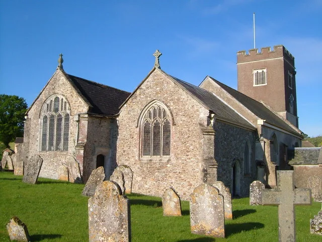
Gittisham — village in Devon, England, UK.

Wikimedia Commons contributors — see linked file page for photographer and licence licence
Plan your visit
- Typical visit
- 3 h–6 h
- Nearest railway station
- Honiton · 3.7 km
- Free entry
- Family-friendly
- Dog-friendly
About
Gittisham is a town, city, village or settlement in the United Kingdom. It covers approximately 950 km². Recent population estimates put it at around 548 people. Wikidata describes it as: "village in Devon, England, UK". Coordinates: 50.7756°, -3.2282°.
Photo gallery
Protected designations
- Area of Outstanding Natural Beauty: East Devon
Designations sourced from Natural England open data under OGL v3.
From the Wikipedia article
Gittisham is a village and civil parish in East Devon, Devon, England, near Honiton. The village is 3 miles (5 km) from Ottery St Mary and it has a church called St Michael. The parish is surrounded, clockwise from the north, by the parishes of Awliscombe, Honiton, Sidmouth, Ottery St Mary, Feniton and Buckerell. In 2021 the parish had a population of 838.
Excerpt from Wikipedia under CC BY-SA 4.0. See the source article linked in Sources below.
Background
History
The Roman road from Axminster to Exeter (whose course is followed by the A30 road) passes through the northern edge of the parish. In about AD 60 the Romans built a small fort on the road less than a kilometre NW of the modern village. It appears to have been dismantled by the army around AD 80: so its military existence more or less coincided with the presence of legions at Exeter before they moved to south Wales. There was also a small civilian settlement at the Gittisham fort. (Devon and Dartmoor Historic Environment Record) The Gittisham fort was about halfway between Axminster and Exeter, and stood at the point on the Roman road nearest to Hembury hill fort, where there is evidence of…
Sourced from Wikipedia under CC BY-SA 4.0.
- Coordinates
- 50.7756, -3.2282
- County
- Devon
- District
- East Devon
- Parish
- Gittisham
- Postcode
- EX14 3AE
- Parliamentary constituency
- Honiton and Sidmouth
- Population
- 548
- Nearest railway station
- Honiton — 3.7 km
Sources
- wikidata: Q1852679 (CC0)
- wikipedia: Gittisham (CC BY-SA 4.0)
- commons: St Michael's church, Gittisham - geograph.org.uk - 174037.jpg (CC BY-SA 4.0)
Other places nearby
Loading nearby places…
Nearby
 📷 5
📷 5Historic churches · South West England
Church of St Michael
Church of St Michael — church in Gittisham, Devon, England, UK.
 📷 3
📷 3Historic houses · South West England
Combe House
Combe House — a Grade I-listed historic house in england-south-west, United Kingdom.
 📷 3
📷 3Archaeological sites · South West England
Gittisham Roman Fort
Gittisham Roman Fort — a archaeological in england-south-west, United Kingdom.
 📷 3
📷 3Natural landmarks · South West England
Honiton Show
Honiton Show — a other in england-south-west, United Kingdom.
 📷 3
📷 3Historic bridges · South West England
Fenny Bridge
Fenny Bridge — Grade II listed building-listed bridge in england-south-west, United Kingdom.
Hotels · South West England
Deer Park Hotel
Deer Park Hotel — a hotel in england south west.
More towns in this region
 Flagship📷 10
Towns & cities · South West England
All Saints
All Saints — village and civil parish in Devon, England, UK.
 Flagship📷 10
Towns & cities · South West England
Axmouth
Axmouth — village and civil parish in Devon, England, UK.
 ★ Iconic📷 10
Towns & cities · South West England
Beer
Beer — village and civil parish in Devon, UK.
 Flagship📷 10
Towns & cities · South West England
Branscombe
Branscombe — village and civil parish in Devon, UK.
Frequently asked questions
- Where is Gittisham?
- Gittisham is in Devon, South-West England, United Kingdom (postcode EX14 3AE), in the parish of Gittisham.
- Is Gittisham a protected site?
- Yes — Gittisham is part of the East Devon National Landscape (AONB).
- Is Gittisham free to visit?
- Yes, Gittisham is free to enter.
- How do I get to Gittisham?
- The nearest railway station is Honiton, about 3.7 km away. Drivers can navigate to postcode EX14 3AE.