Reservoirs & lochs · Scottish Lowlands
Fontburn
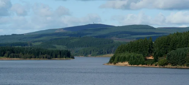
Fontburn — reservoir in the United Kingdom.

Wikimedia Commons contributors — see linked file page for photographer and licence licence
Plan your visit
- Typical visit
- 1 h–2.5 h
- Free entry
- Dog-friendly
About
Fontburn is a reservoir in the United Kingdom. Wikidata describes it as: "reservoir in the United Kingdom". Coordinates: 55.2360°, -1.9310°.
Photo gallery
Protected designations
- Site of Special Scientific Interest: Northumberland Shore SSSI
Designations sourced from Natural England open data under OGL v3.
From the Wikipedia article
Fontburn is a drinking water reservoir situated 10 miles (16 km) northwest of the market town of Morpeth, and immediately to the east of Harwood Forest in Northumberland, England. It has a surface area of 34.979 ha and a mean depth of 9.644 m, a catchment area of 3061 ha, and is situated at 185 m altitude.
Excerpt from Wikipedia under CC BY-SA 4.0. See the source article linked in Sources below.
- Coordinates
- 55.2360, -1.9310
- District
- Northumberland
- Parish
- Hollinghill
- Postcode
- NE61 4PL
- Parliamentary constituency
- North Northumberland
Sources
- wikidata: Q5465157 (CC0)
- wikipedia: Fontburn (CC BY-SA 4.0)
- commons: Fontburnreservoir2.jpg (CC BY-SA 4.0)
Other places nearby
Loading nearby places…
Nearby
 📷 4
📷 4Mines & mining heritage · North East England
Fontburn Halt railway station
Fontburn Halt railway station in England North East, United Kingdom.
 📷 3
📷 3Historic houses · Scottish Lowlands
Pele
Pele — a historic house in scotland-lowlands, United Kingdom.
 📷 3
📷 3Wildlife reserves · North East England
Fallowlees Flush
Fallowlees Flush in England North East, United Kingdom.
 📷 4
📷 4Heritage railway stations · North East England
Ewesley railway station
Ewesley railway station in England North East, United Kingdom.
 📷 4
📷 4Wildlife reserves · North East England
Greenleighton Quarry
Greenleighton Quarry in England North East, United Kingdom.
Campsites · Scottish Lowlands
Nunnykirk Scout Campsite
Nunnykirk Scout Campsite — a campsite in scotland lowlands.
More places in this region
 Flagship📷 5
Reservoirs & lochs · Scottish Lowlands
Kielder Water
Kielder Water — reservoir in Northumberland, England, UK, on the River North Tyne.
 Flagship📷 3
Reservoirs & lochs · Scottish Lowlands
Q1200405
Q1200405 — reservoir on the border between County Durham and Northumberland, in England.
 📷 3
📷 3Reservoirs & lochs · Scottish Lowlands
Alemoor Reservoir
Alemoor Reservoir — reservoir lake in Scottish Borders, Scotland, UK, on Ale Water.
 📷 3
📷 3Reservoirs & lochs · Scottish Lowlands
Aucha Lochy
Aucha Lochy — reservoir on Kintyre, Argyll and Bute, Scotland, UK, outflows south to Auchalochy Burn.
Frequently asked questions
- Where is Fontburn?
- Fontburn is in the Scottish Lowlands, United Kingdom (postcode NE61 4PL), in the parish of Hollinghill.
- Is Fontburn a protected site?
- Yes — Fontburn is part of the Northumberland Shore SSSI Site of Special Scientific Interest.
- How do I get to Fontburn?
- Drivers can navigate to postcode NE61 4PL. It sits within the North Northumberland parliamentary constituency.