Natural landmarks · Scottish Highlands
Foinaven
Also known as: Fionne Bheinn
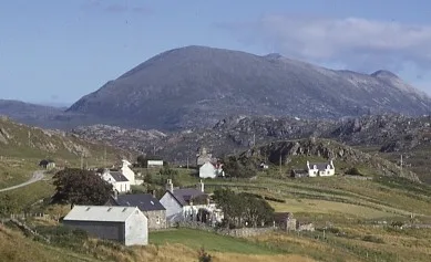
Foinaven — mountain in Highland, Scotland, UK.

Wikimedia Commons contributors — see linked file page for photographer and licence licence
Plan your visit
- Typical visit
- 1 h–2 h
- Free entry
- Dog-friendly
About
Foinaven is a named natural landmark in the United Kingdom. Heritage designation: Site of Special Scientific Interest. Wikidata describes it as: "mountain in Highland, Scotland, UK". Coordinates: 58.4121°, -4.8860°.
Photo gallery
From the Wikipedia article
Foinaven (Scottish Gaelic: Foinnebheinn ) is a mountain in Scotland, situated in the northwest corner of the Scottish Highlands. It has a conspicuous white cap of Cambrian quartzite which overlies the ancient Lewisian gneiss basement. This relatively thin quartzite sheet is resistant to normal chemical weathering and erosion, hence the survival of a chain of similar peaks such as neighbouring Arkle (Arcail) and Cranstackie, but is vulnerable to frost shattering, hence the sharp crests around the corries and extensive block fields and scree slopes. Foinaven was named Foinne Bheinn on the first Ordnance Survey map edition of 1878, a name now added back. Its surveyed height was 2980 ft. This was revised to 914 metres on early metric editions, thus potentially qualifying it as a Munro, but an accurate survey in 2007 confirmed that at 911 metres it falls 12 feet (3.7 metres) short of the required 3,000 ft (914.4 m).. The mountain extends for 8 km, with four main tops above 800 m, the highest being named Ganu Mòr. However on the first edition of 1878, it appears as Ceann Mòr, a more likely origin as ganu has no meaning in Gaelic (possibly a transcription error in redrawing the map for the second edition). This matches with the north top always being Ceann Garbh, thus 'big head' and 'rough head'. The two southern tops are nameless, but a prominent spur is noted as A' Cheir Ghorm. The mountain inspired the name of the racehorse that went on to win the 1967 Grand National at odds of 100–1.
Excerpt from Wikipedia under CC BY-SA 4.0. See the source article linked in Sources below.
- Coordinates
- 58.4121, -4.8860
- Address
- Sutherland, Scotland
- Official site
- news.bbc.co.uk
Sources
- wikidata: Q3406446 (CC0)
- wikipedia: Foinaven (CC BY-SA 4.0)
- commons: Foinaven from Achriesgill.jpg (CC BY-SA 4.0)
Other places nearby
Loading nearby places…
Nearby
 📷 3
📷 3Mountains & hills · Scottish Highlands
Ganu Mòr
Ganu Mòr — a mountain in scotland-highlands, United Kingdom.
 📷 3
📷 3Mountains & hills · Scottish Highlands
Foinaven
Foinaven — Named summit at 911 m.
 📷 3
📷 3Mountains & hills · Scottish Highlands
A' Chèir Ghorm
A' Chèir Ghorm — a mountain in scotland-highlands, United Kingdom.
 📷 3
📷 3Mountains & hills · Scottish Highlands
Cadha na Beucaich
Cadha na Beucaich — a mountain in scotland-highlands, United Kingdom.
 📷 3
📷 3Mountains & hills · Scottish Highlands
An t-Sàil Mhòr
An t-Sàil Mhòr — a mountain in scotland-highlands, United Kingdom.
 📷 4
📷 4Reservoirs & lochs · Scottish Highlands
Loch Dìonaird
Loch Dìonaird in Scotland Islands, United Kingdom.
More natural landmarks in this region
 Flagship📷 3
Natural landmarks · Scottish Highlands
Dunalastair Water
Dunalastair Water — lake in Perth and Kinross, Scotland, UK, on the River Tummel.
 Flagship📷 3
Natural landmarks · Scottish Highlands
Loch Arkaig
Loch Arkaig — lake in Highland, Scotland, UK, outflows east to River Arkaig.
 Flagship📷 3
Natural landmarks · Scottish Highlands
Loch Assynt
Loch Assynt — lake in Highland, Scotland, UK, outflows to the River Inver and Loch na Garbh Uidhe.
 Flagship📷 3
Natural landmarks · Scottish Highlands
Loch Awe
Loch Awe — lake in Argyll and Bute, Scotland, UK, outflows to the River Awe.
Frequently asked questions
- Where is Foinaven?
- Foinaven is in the Scottish Highlands, United Kingdom.
- Is Foinaven a listed building?
- Foinaven is officially recognised as Site of Special Scientific Interest listed.
- Is Foinaven free to visit?
- Yes, Foinaven is free to enter.