Museums · Yorkshire & the Humber
Filey
Filey () is a seaside town and civil parish in North Yorkshire, England. It is located between Scarborough and Bridlington on Filey Bay. Although previously a fishing village, it has a large sandy bea

habiloid — CC BY-SA 2.0 via Wikimedia Commons licence
Plan your visit
- Typical visit
- 1.5 h–3 h
- Best time of year
- Year-round
- Family-friendly
- Limited wheelchair access
About
Filey () is a seaside town and civil parish in North Yorkshire, England. It is located between Scarborough and Bridlington on Filey Bay. Although previously a fishing village, it has a large sandy beach and became a popular tourist resort. According to the 2011 UK census, Filey parish had a population of 6,981, in comparison to the 2001 UK census population figure of 6,819, and a population of 6,870 in 1991. Filey was historically mainly within the East Riding of Yorkshire, although until 1888 a small part of the town, including its parish church, was in the North Riding of Yorkshire. In 1974 the town was transferred to the new county of North Yorkshire.
Photo gallery
From the Wikipedia article
Filey () is a seaside town and civil parish in North Yorkshire, England. It is located between Scarborough and Bridlington on Filey Bay. Although previously a fishing village, it has a large sandy beach and became a popular tourist resort. According to the 2011 UK census, Filey parish had a population of 6,981, in comparison to the 2001 UK census population figure of 6,819, and a population of 6,870 in 1991. Filey was historically mainly within the East Riding of Yorkshire, although until 1888 a small part of the town, including its parish church, was in the North Riding of Yorkshire. In 1974 the town was transferred to the new county of North Yorkshire.
Excerpt from Wikipedia under CC BY-SA 4.0. See the source article linked in Sources below.
Background
History
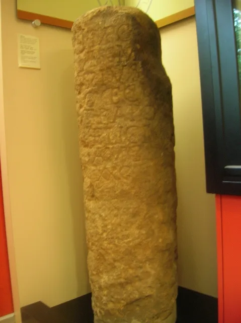
]] In 1857 the foundations of a 4th-century Roman signal station were discovered at the Carr Naze cliff edge at the northern end of Filey Bay. The structure is 50 m long with a square tower 14 m wide, a defensive ditch and ramparts from a later era. Excavations at the time of the find and subsequently in the 1920s and 1990s uncovered Roman pottery and hoards of coins. The site is a protected Scheduled Monument. The find of Roman remains supports the case for Filey being the Roman settlement of Portus Felix. The origin of the name Filey is uncertain. One theory derives it from the Old English fīfelēg meaning 'monster island' referring to the shape of a rock projection at the shore. Other…
Sourced from Wikipedia under CC BY-SA 4.0.
- Coordinates
- 54.2097, -0.2889
- District
- North Yorkshire
- Parish
- Filey
- Postcode
- YO14 9AB
- Parliamentary constituency
- Thirsk and Malton
- Official site
- fileymuseum.co.uk
Sources
- wikipedia: Filey (CC BY-SA 4.0)
Featured in this guide
Other places nearby
Loading nearby places…
Nearby
 📷 3
📷 3Memorials & monuments · Yorkshire & the Humber
Filey War Memorial Archway
Filey War Memorial Archway — Grade II listed building-listed memorial in england-yorkshire, United Kingdom.
 📷 3
📷 3Zoos & aquariums · Yorkshire & the Humber
Memorial Gardens Aviary
Memorial Gardens Aviary — a zoo aquarium in england-yorkshire, United Kingdom.
 📷 3
📷 3Theatres · Yorkshire & the Humber
The Evron Centre Theatre
The Evron Centre Theatre is a theatre in the United Kingdom.
 📷 3
📷 3Theatres · Yorkshire & the Humber
Brig Cinema
Brig Cinema in England Yorkshire, United Kingdom.
 📷 3
📷 3Museums · Yorkshire & the Humber
Filey Museum
Filey Museum — a museum in england-yorkshire, United Kingdom.
 📷 3
📷 3Distilleries · Yorkshire & the Humber
Filey Distillery
Filey Distillery — Whisky/spirit distillery.
More museums in this region
 📷 3
📷 3Museums · Yorkshire & the Humber
Aldborough Roman Town
Aldborough Roman Town — Heritage Museum in Yorkshire, England, UK.
 📷 3
📷 3Museums · Yorkshire & the Humber
Bayle Museum
Bayle Museum — Local museum in Bridlington, England.
Museums · Yorkshire & the Humber
BD1 Gallery
BD1 Gallery — closed gallery in Bradford, West Yorkshire.
 📷 5
📷 5Museums · Yorkshire & the Humber
Beck Isle Museum
Beck Isle Museum — museum in Pickering, North Yorkshire, England, United Kingdom.
Frequently asked questions
- Where is Filey?
- Filey is in Yorkshire & the Humber, in the United Kingdom — coordinates 54.2097°, -0.2889°.
- Is Filey wheelchair accessible?
- Partially — OpenStreetMap notes limited wheelchair access at Filey. Check ahead for specific facilities.