Reservoirs & lochs · West Midlands
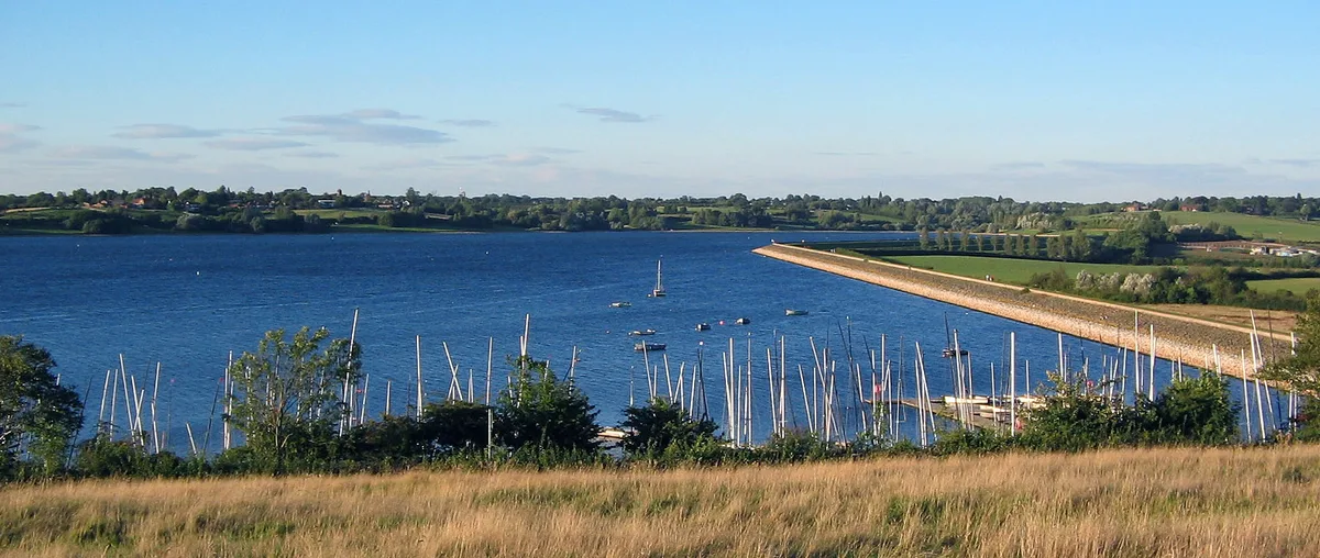
Farmoor Reservoir
Farmoor Reservoir — lake in the United Kingdom.
.jpg?width=1200)
Wikimedia Commons contributors — see linked file page for photographer and licence licence
.jpg)
Plan your visit
- Typical visit
- 1 h–2.5 h
- Nearest railway station
- Oxford · 6.0 km
- Free entry
- Dog-friendly
About
Farmoor Reservoir is a reservoir in the United Kingdom. Wikidata describes it as: "lake in the United Kingdom". Coordinates: 51.7554°, -1.3567°.
Photo gallery
From the Wikipedia article
Farmoor Reservoir is a public supply reservoir at Farmoor, Oxfordshire, England, about 5 miles (8 km) west of Oxford. It is adjacent to the River Thames. Like most of the reservoirs in the Thames Valley, it is a pumped storage reservoir which was not formed by damming a watercourse in a valley. In this case the banks were raised above the local ground level using material excavated from within the bowl of the reservoir. The reservoir is divided into two: Stage 1 to the north and Stage 2 to the south. The two reservoirs stages are separated by a causeway. The water improves in quality during its retention in the reservoir as solids settle and organic contaminants are adsorbed and degraded through a combination of natural biological processes aided by sunlight and oxygenation. As well as Oxford and other localities, Farmoor supplies the town of Swindon, some 25 miles (40 km) to the southwest via a trunk main installed in 1986. The reservoir is supplied by water abstracted from the River Thames at a flowrate of about 1.62 m3/s or 140 million litres per day. Water enters the reservoir near the western end of the causeway.
Excerpt from Wikipedia under CC BY-SA 4.0. See the source article linked in Sources below.
- Coordinates
- 51.7554, -1.3567
- County
- Oxfordshire
- District
- Vale of White Horse
- Parish
- Cumnor
- Postcode
- OX2 9NR
- Parliamentary constituency
- Oxford West and Abingdon
- Nearest railway station
- Oxford — 6 km
- Official site
- www.thameswater.co.uk
Sources
- wikidata: Q5435934 (CC0)
- wikipedia: Farmoor Reservoir (CC BY-SA 4.0)
- commons: Farmoor Reservoir (74892).jpg (CC BY-SA 4.0)
Other places nearby
Loading nearby places…
Nearby
 📷 3
📷 3Canal locks · West Midlands
Pinkhill Lock
Pinkhill Lock — lock on the River Thames in Oxfordshire, England.
Campsites · West Midlands
Valley Farm Campsite
Valley Farm Campsite — a campsite in england west midlands.
Campsites · West Midlands
Oxford Riverside Glamping
Oxford Riverside Glamping — a campsite in england west midlands.
 📷 3
📷 3Canal locks · West Midlands
Eynsham Lock
Eynsham Lock — lock on the River Thames.
Caravan parks · West Midlands
Bablock Hythe Caravan Park
Bablock Hythe Caravan Park — a caravan park in england west midlands.
Campsites · West Midlands
Hill End Outdoor Education Centre
Hill End Outdoor Education Centre — a campsite in england west midlands.
More places in this region
 Flagship📷 3
Reservoirs & lochs · West Midlands
Draycote Water
Draycote Water — reservoir in the United Kingdom.
 Flagship📷 3
Reservoirs & lochs · West Midlands
Netherton Reservoir
Netherton Reservoir — reservoir in West Midlands, England, UK.
 📷 3
📷 3Reservoirs & lochs · West Midlands
Abingdon Reservoir
Abingdon Reservoir — proposed reservoir in Oxfordshire, England, UK.
 📷 3
📷 3Reservoirs & lochs · West Midlands
Aston Reservoir
Aston Reservoir — reservoir in Birmingham, West Midlands, England, UK.
Frequently asked questions
- Where is Farmoor Reservoir?
- Farmoor Reservoir is in West Midlands, in the United Kingdom — coordinates 51.7554°, -1.3567°. The nearest railway station is Oxford, around 6 km away.
- Is Farmoor Reservoir free to visit?
- Yes — admission to Farmoor Reservoir is free.