Museums · London
Eynsford
Eynsford ( or ) is a village and civil parish in the Sevenoaks District of Kent, England. It is located 3.3 miles (5 km) south east of Swanley, and 7 miles (11 km) south of Dartford, which is the vill

Jim Osley — CC BY-SA 2.0 via Wikimedia Commons licence
Plan your visit
- Typical visit
- 1.5 h–3 h
- Best time of year
- Year-round
- Family-friendly
- Limited wheelchair access
About
Eynsford ( or ) is a village and civil parish in the Sevenoaks District of Kent, England. It is located 3.3 miles (5 km) south east of Swanley, and 7 miles (11 km) south of Dartford, which is the village's postal town. Eynsford forms part of the London commuter belt. The village including its farmland and woods occupies the northern half of the triangle formed by three motorways in west Kent barring its very northernmost part which is Farningham. This area is undulating and has a large minority of woodland. In the south of the parish is Lullingstone, much of which was owned for many centuries by the large, late medieval Lullingstone Castle, whereas other parts of the village were owned by Eynsford Castle, which is older. Well before the founding of the Kingdom of England, Lullingstone Roman villa was founded in this part of the parish, which is open to the public today. The Darent Valley Path takes in a cross-section of the area.
Photo gallery
From the Wikipedia article
Eynsford ( or ) is a village and civil parish in the Sevenoaks District of Kent, England. It is located 3.3 miles (5 km) south east of Swanley, and 7 miles (11 km) south of Dartford, which is the village's postal town. Eynsford forms part of the London commuter belt. The village including its farmland and woods occupies the northern half of the triangle formed by three motorways in west Kent barring its very northernmost part which is Farningham. This area is undulating and has a large minority of woodland. In the south of the parish is Lullingstone, much of which was owned for many centuries by the large, late medieval Lullingstone Castle, whereas other parts of the village were owned by Eynsford Castle, which is older. Well before the founding of the Kingdom of England, Lullingstone Roman villa was founded in this part of the parish, which is open to the public today. The Darent Valley Path takes in a cross-section of the area.
Excerpt from Wikipedia under CC BY-SA 4.0. See the source article linked in Sources below.
Background
Description
Eynsford is first mentioned in writing in 864, as "Egenes homme". The derivation is unclear, but one possibility is that it represents "Ægen's river-meadow", from the Old English hamm "river-meadow, enclosure". In 1801 the village had the highest population in the Dartford area, at 841 persons. In the centre of the village is a ford over the river, with a picturesque hump-back bridge alongside. There are many old buildings including the 16th-century Plough Inn and the Old Mill. The church is dedicated to St Martin. In about 1163, Thomas Becket is reputed to have excommunicated William de Eynsford, the owner of Eynsford castle. The excommunication was cancelled by King Henry II and the issue…
Sourced from Wikipedia under CC BY-SA 4.0.
- Coordinates
- 51.3650, 0.2110
- County
- Kent
- District
- Sevenoaks
- Parish
- Eynsford
- Postcode
- DA4 0HB
- Parliamentary constituency
- Sevenoaks
- Official site
- web.archive.org
Sources
- wikipedia: Eynsford (CC BY-SA 4.0)
Other places nearby
Loading nearby places…
Nearby
.jpg?width=1200) 📷 5
📷 5Historic churches · London
Church of Saint Martin
Church of Saint Martin — Grade I listed church in Eynsford, Kent, England, UK.
 📷 5
📷 5Historic bridges · London
Eynsford Bridge
Eynsford Bridge — scheduled monument-listed bridge in england-london, United Kingdom.
 📷 5
📷 5Memorials & monuments · London
Eynsford War Memorial
Eynsford War Memorial is a memorial in the United Kingdom.
 📷 5
📷 5Castles · London
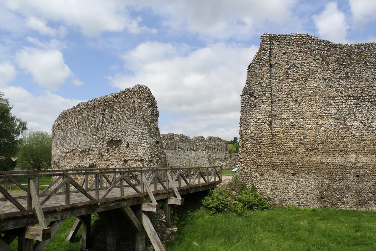
Eynsford Castle
Eynsford Castle — castle, now ruinous, in Eynsford, Kent, England, UK.
 📷 5
📷 5Viewpoints · London
View of viaduct
View of viaduct is a viewpoint in the United Kingdom.
_-_geograph.org.uk_-_1735445.jpg?width=1200) 📷 5
📷 5Historic bridges · London
Eynsford Viaduct
Eynsford Viaduct is a historic bridge in the United Kingdom.
More museums in this region
 Flagship📷 10
Museums · London
Kenwood House
Kenwood House — art museum and historic house in Hampstead, London.
 📷 5
📷 5Museums · London
American Air Museum
American Air Museum — museum at Imperial War Museum Duxford, Cambridgeshire, England, UK.
 📷 5
📷 5Museums · London
Amora London
Amora London — European touring exhibition dedicated to love, relationships and sexual wellbeing.
 📷 5
📷 5Museums · London
Antique Breadboard Museum
Antique Breadboard Museum — small museum in Putney, London, England, UK.
Frequently asked questions
- Where is Eynsford?
- Eynsford is in London, in the United Kingdom — coordinates 51.3650°, 0.2110°.
- Is Eynsford wheelchair accessible?
- Partially — OpenStreetMap notes limited wheelchair access at Eynsford. Check ahead for specific facilities.