Natural landmarks · North West England
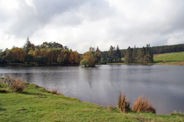
Esthwaite Water
Esthwaite Water — lake in the United Kingdom.

Wikimedia Commons contributors — see linked file page for photographer and licence licence
Plan your visit
- Typical visit
- 1 h–2 h
- Nearest railway station
- Windermere · 5.7 km
- Free entry
- Dog-friendly
About
Esthwaite Water is a named natural landmark in the United Kingdom. It covers approximately 1 km². Heritage designation: Site of Special Scientific Interest. Wikidata describes it as: "lake in the United Kingdom". Coordinates: 54.3589°, -2.9846°.
Photo gallery
Protected designations
- Site of Special Scientific Interest: Esthwaite Water SSSI
- Ramsar wetland: Esthwaite Water
Designations sourced from Natural England open data under OGL v3.
From the Wikipedia article
Esthwaite Water is one of the smaller and lesser known lakes in the Lake District National Park in Cumbria, England. It is situated between the much larger lakes of Windermere and Coniston Water in the Furness area, historically part of Lancashire. To the north is the village of Hawkshead and to the west is Grizedale Forest. The lake covers around 280 acres (1.1 km2) and is known for its excellent fishing, particularly trout and pike. It has been designated as a site of special scientific interest.
Excerpt from Wikipedia under CC BY-SA 4.0. See the source article linked in Sources below.
- Coordinates
- 54.3589, -2.9846
- District
- Westmorland and Furness
- Parish
- Claife
- Postcode
- LA22 0JY
- Parliamentary constituency
- Westmorland and Lonsdale
- Nearest railway station
- Windermere — 5.7 km
- Official site
- rsis.ramsar.org
Sources
- wikidata: Q821474 (CC0)
- wikipedia: Esthwaite Water (CC BY-SA 4.0)
- commons: Esthwaite Water aerial photograph July 2019.jpg (CC BY-SA 4.0)
Other places nearby
Loading nearby places…
Nearby
 📷 3
📷 3Historic houses · North West England
Esthwaite Lodge
Esthwaite Lodge — house in Hawkshead, Westmorland and Furness, Cumbria, England, UK.
Campsites · North West England
YHA Hawkshead camp site
YHA Hawkshead camp site — a campsite in england north west.
 📷 5
📷 5Other places · North West England
Near and Far Sawrey
Near and Far Sawrey — a other in england-north-west, United Kingdom.
 📷 3
📷 3Natural landmarks · North West England
Moss Eccles Tarn
Moss Eccles Tarn — lake in the United Kingdom.
 📷 5
📷 5Museums · North West England
Hill Top, Cumbria
Hill Top is a 17th-century house in Near Sawrey near Hawkshead, in the English county of Cumbria. It is an example of Lakeland vernacular architecture with random stone walls and slate roof. The house
Caravan parks · North West England
Lakes Lodges - Esthwaite View
Lakes Lodges - Esthwaite View — a caravan park in england north west.
More natural landmarks in this region
 ★ Iconic📷 4
Natural landmarks · North West England
Coniston Water
Lake District lake — Swallows and Amazons setting and Donald Campbell water-speed history.
 📷 3
📷 3Natural landmarks · North West England
Elter Water
Elter Water — lake in the United Kingdom.
 Flagship📷 5
Natural landmarks · North West England
Semerwater
Semerwater — lake in North Yorkshire, England, UK.
 Flagship📷 3
Natural landmarks · North West England
Stickle Tarn
Stickle Tarn — lake near Harrison Stickle, Langdale, Cumbria, United Kingdom.
Frequently asked questions
- Where is Esthwaite Water?
- Esthwaite Water is in North-West England, United Kingdom (postcode LA22 0JY), in the parish of Claife.
- Is Esthwaite Water a listed building?
- Esthwaite Water is officially recognised as Site of Special Scientific Interest listed.
- Is Esthwaite Water a protected site?
- Yes — Esthwaite Water is part of the Esthwaite Water SSSI Site of Special Scientific Interest and the Esthwaite Water Ramsar wetland.
- Is Esthwaite Water free to visit?
- Yes, Esthwaite Water is free to enter.
- How do I get to Esthwaite Water?
- The nearest railway station is Windermere, about 5.7 km away. Drivers can navigate to postcode LA22 0JY.