Museums · Yorkshire & the Humber
Easingwold
Easingwold is a market town and civil parish in North Yorkshire, England. Historically part of the North Riding of Yorkshire, it had a population of 4,233 at the 2001 census, increasing to 4,627 at th

Ian S — CC BY-SA 2.0 via Wikimedia Commons licence
Plan your visit
- Typical visit
- 1.5 h–3 h
- Best time of year
- Year-round
- Family-friendly
- Limited wheelchair access
About
Easingwold is a market town and civil parish in North Yorkshire, England. Historically part of the North Riding of Yorkshire, it had a population of 4,233 at the 2001 census, increasing to 4,627 at the 2011 Census. It is located about 12 miles (19 km) north of York, near the foot of the Howardian Hills.
Photo gallery
From the Wikipedia article
Easingwold is a market town and civil parish in North Yorkshire, England. Historically part of the North Riding of Yorkshire, it had a population of 4,233 at the 2001 census, increasing to 4,627 at the 2011 Census. It is located about 12 miles (19 km) north of York, near the foot of the Howardian Hills.
Excerpt from Wikipedia under CC BY-SA 4.0. See the source article linked in Sources below.
Background
History
The town is mentioned in the Domesday Book of 1086 as "Eisicewalt" in the Bulford hundred. At the time of the Norman conquest, the manor was owned by Earl Morcar, but subsequently passed to the King. In 1265 the manor was passed to Edmund Crouchback by his father, Henry III. The manor was caught up in the dispute between the 2nd Earl of Lancaster and Edward I and the manor passed back to the crown following the Battle of Boroughbridge in 1322 which resulted in the execution of the Earl at Pontefract. The manor was restored to the Earl's brother some six years later, but he left no male heir, so the lands passed to his son-in-law, John of Gaunt in 1361. The lands were next granted to his…
Sourced from Wikipedia under CC BY-SA 4.0.
- Coordinates
- 54.1214, -1.1922
- District
- North Yorkshire
- Parish
- Easingwold
- Postcode
- YO61 3AG
- Parliamentary constituency
- Wetherby and Easingwold
Sources
- wikipedia: Easingwold (CC BY-SA 4.0)
Other places nearby
Loading nearby places…
Nearby
Hotels · Yorkshire & the Humber
The George Hotel
The George Hotel — a hotel in england yorkshire.
 📷 3
📷 3Memorials & monuments · Yorkshire & the Humber
Easingwold War Memorial
Easingwold War Memorial — Grade II listed building-listed memorial in england-yorkshire, United Kingdom.
 📷 3
📷 3Historic churches · Yorkshire & the Humber
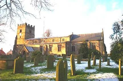
St John and All Saints' Church, Easingwold
St John and All Saints' Church, Easingwold — church in Easingwold, North Yorkshire, UK.
 📷 4
📷 4Gardens · Yorkshire & the Humber
1-13 (Consecutive), Cedar Place
1-13 (Consecutive), Cedar Place — a garden in england-yorkshire, United Kingdom.
 📷 3
📷 3Historic houses · Yorkshire & the Humber
Duncalf's Barn
Duncalf's Barn — a historic house in england-yorkshire, United Kingdom.
 📷 3
📷 3Natural landmarks · Yorkshire & the Humber
Easingwold Maize Maze
Easingwold Maize Maze — a other in england-yorkshire, United Kingdom.
More museums in this region
 📷 3
📷 3Museums · Yorkshire & the Humber
Aldborough Roman Town
Aldborough Roman Town — Heritage Museum in Yorkshire, England, UK.
 📷 3
📷 3Museums · Yorkshire & the Humber
Bayle Museum
Bayle Museum — Local museum in Bridlington, England.
Museums · Yorkshire & the Humber
BD1 Gallery
BD1 Gallery — closed gallery in Bradford, West Yorkshire.
 📷 5
📷 5Museums · Yorkshire & the Humber
Beck Isle Museum
Beck Isle Museum — museum in Pickering, North Yorkshire, England, United Kingdom.
Frequently asked questions
- Where is Easingwold?
- Easingwold is in Yorkshire & the Humber, in the United Kingdom — coordinates 54.1214°, -1.1922°.
- Is Easingwold wheelchair accessible?
- Partially — OpenStreetMap notes limited wheelchair access at Easingwold. Check ahead for specific facilities.